Boscobel Topo Map Wisconsin
To zoom in, hover over the map of Boscobel
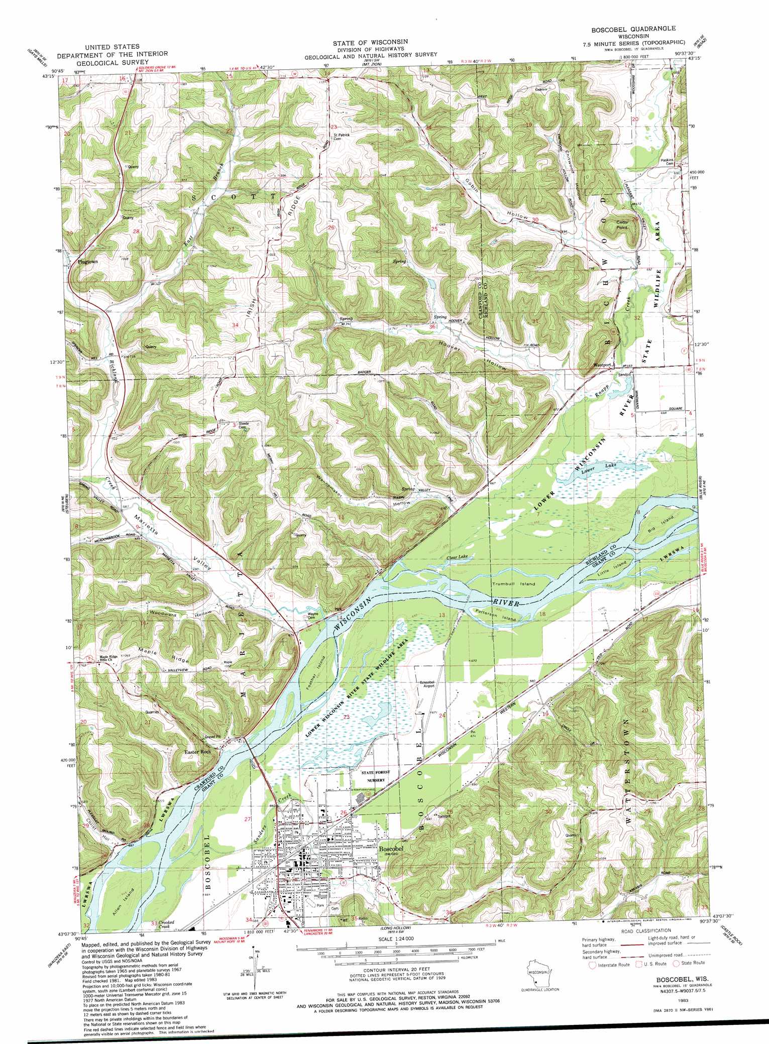
USGS Topo Quad 43090b6 - 1:24,000 scale
| Topo Map Name: | Boscobel |
| USGS Topo Quad ID: | 43090b6 |
| Print Size: | ca. 21 1/4" wide x 27" high |
| Southeast Coordinates: | 43.125° N latitude / 90.625° W longitude |
| Map Center Coordinates: | 43.1875° N latitude / 90.6875° W longitude |
| U.S. State: | WI |
| Filename: | o43090b6.jpg |
| Download Map JPG Image: | Boscobel topo map 1:24,000 scale |
| Map Type: | Topographic |
| Topo Series: | 7.5´ |
| Map Scale: | 1:24,000 |
| Source of Map Images: | United States Geological Survey (USGS) |
| Alternate Map Versions: |
Boscobel WI 1983, updated 1983 Download PDF Buy paper map Boscobel WI 2010 Download PDF Buy paper map Boscobel WI 2013 Download PDF Buy paper map Boscobel WI 2016 Download PDF Buy paper map |
1:24,000 Topo Quads surrounding Boscobel
Rising Sun |
Readstown |
Sugar Grove |
Sabin |
Gillingham |
Mount Sterling |
Gays Mills |
Mount Zion |
Boaz |
Richland Center |
Crowley Ridge |
Steuben |
Boscobel |
Blue River |
Muscoda |
Wauzeka West |
Wauzeka East |
Long Hollow |
Castle Rock |
Highland West |
Bloomington |
Mount Hope |
Fennimore |
Stitzer |
Montfort |
> Back to 43090a1 at 1:100,000 scale
> Back to 43090a1 at 1:250,000 scale
> Back to U.S. Topo Maps home
Boscobel topo map: Gazetteer
Boscobel: Airports
Boscobel Airport elevation 203m 666′Memorial Hospital Heliport elevation 207m 679′
Boscobel: Capes
Cedar Point elevation 278m 912′Boscobel: Dams
Windward Farms G8915 Dam elevation 269m 882′Boscobel: Islands
Allen Island elevation 197m 646′Big Island elevation 200m 656′
Feather Island elevation 198m 649′
Little Island elevation 200m 656′
Patterson Island elevation 200m 656′
Trumbull Island elevation 199m 652′
Boscobel: Lakes
Clear Lake elevation 198m 649′Lower Lake elevation 199m 652′
Boscobel: Parks
Richwood Bottoms State Natural Area elevation 199m 652′Boscobel: Populated Places
Boscobel elevation 207m 679′Easter Rock elevation 197m 646′
Harmony Hill elevation 337m 1105′
Plugtown elevation 236m 774′
Westport elevation 202m 662′
Boscobel: Reservoirs
Tr Knapp Creek 1 Reservoir elevation 269m 882′Boscobel: Ridges
Irish Ridge elevation 336m 1102′Maple Ridge elevation 337m 1105′
Boscobel: Streams
Crooked Creek elevation 195m 639′Knapp Creek elevation 197m 646′
Richland Creek elevation 197m 646′
Sanders Creek elevation 197m 646′
Boscobel: Summits
Rattlesnake Point elevation 309m 1013′Boscobel: Valleys
Chitwood Hollow elevation 210m 688′Christ Hollow elevation 199m 652′
Flynn Hollow elevation 208m 682′
Gobin Hollow elevation 203m 666′
Hoover Hollow elevation 202m 662′
Marietta Valley elevation 207m 679′
Taylor Hollow elevation 207m 679′
Wannamaker Hollow elevation 201m 659′
Woodward Hollow elevation 205m 672′
Boscobel digital topo map on disk
Buy this Boscobel topo map showing relief, roads, GPS coordinates and other geographical features, as a high-resolution digital map file on DVD: