Witoka Topo Map Minnesota
To zoom in, hover over the map of Witoka
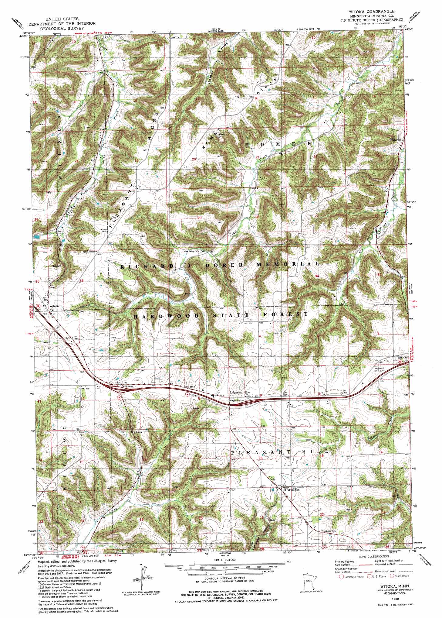
USGS Topo Quad 43091h5 - 1:24,000 scale
| Topo Map Name: | Witoka |
| USGS Topo Quad ID: | 43091h5 |
| Print Size: | ca. 21 1/4" wide x 27" high |
| Southeast Coordinates: | 43.875° N latitude / 91.5° W longitude |
| Map Center Coordinates: | 43.9375° N latitude / 91.5625° W longitude |
| U.S. State: | MN |
| Filename: | o43091h5.jpg |
| Download Map JPG Image: | Witoka topo map 1:24,000 scale |
| Map Type: | Topographic |
| Topo Series: | 7.5´ |
| Map Scale: | 1:24,000 |
| Source of Map Images: | United States Geological Survey (USGS) |
| Alternate Map Versions: |
Witoka MN 1980, updated 1980 Download PDF Buy paper map Witoka MN 1980, updated 1987 Download PDF Buy paper map Witoka MN 2010 Download PDF Buy paper map Witoka MN 2013 Download PDF Buy paper map Witoka MN 2016 Download PDF Buy paper map |
1:24,000 Topo Quads surrounding Witoka
Cochrane |
Fountain City |
Dodge |
Tamarack |
Ettrick |
Rollingstone |
Winona West |
Winona East |
Trempealeau |
Galesville |
Lewiston |
Wilson |
Witoka |
Pickwick |
Holmen |
Rushford West |
Rushford East |
Houston |
Mound Prairie |
La Crescent |
Bratsberg |
Yucatan |
Sheldon |
Caledonia |
Brownsville |
> Back to 43091e1 at 1:100,000 scale
> Back to 43090a1 at 1:250,000 scale
> Back to U.S. Topo Maps home
Witoka topo map: Gazetteer
Witoka: Crossings
Interchange 257 elevation 405m 1328′Witoka: Dams
Hundorf Dam elevation 296m 971′Judy Dam elevation 300m 984′
Loyal Hoseck Detention Structure Number 1 Dam elevation 275m 902′
Loyal Hoseck Detention Structure Number 2 Dam elevation 294m 964′
Pleasant Valley Site Number 10 Dam elevation 268m 879′
Pleasant Valley Site Number 3 Dam elevation 279m 915′
Pleasant Valley Site Number 6 Dam elevation 291m 954′
Pleasant Valley Site Number 7 Dam elevation 297m 974′
Pleasant Valley Site Number 8 Dam elevation 254m 833′
Witoka: Populated Places
Ridgeway elevation 409m 1341′Witoka elevation 406m 1332′
Witoka: Post Offices
Ridgeway Post Office (historical) elevation 409m 1341′Witoka Post Office (historical) elevation 406m 1332′
Witoka: Ridges
Homer Ridge elevation 390m 1279′Pleasant Ridge elevation 392m 1286′
Witoka digital topo map on disk
Buy this Witoka topo map showing relief, roads, GPS coordinates and other geographical features, as a high-resolution digital map file on DVD: