Wykoff Topo Map Minnesota
To zoom in, hover over the map of Wykoff
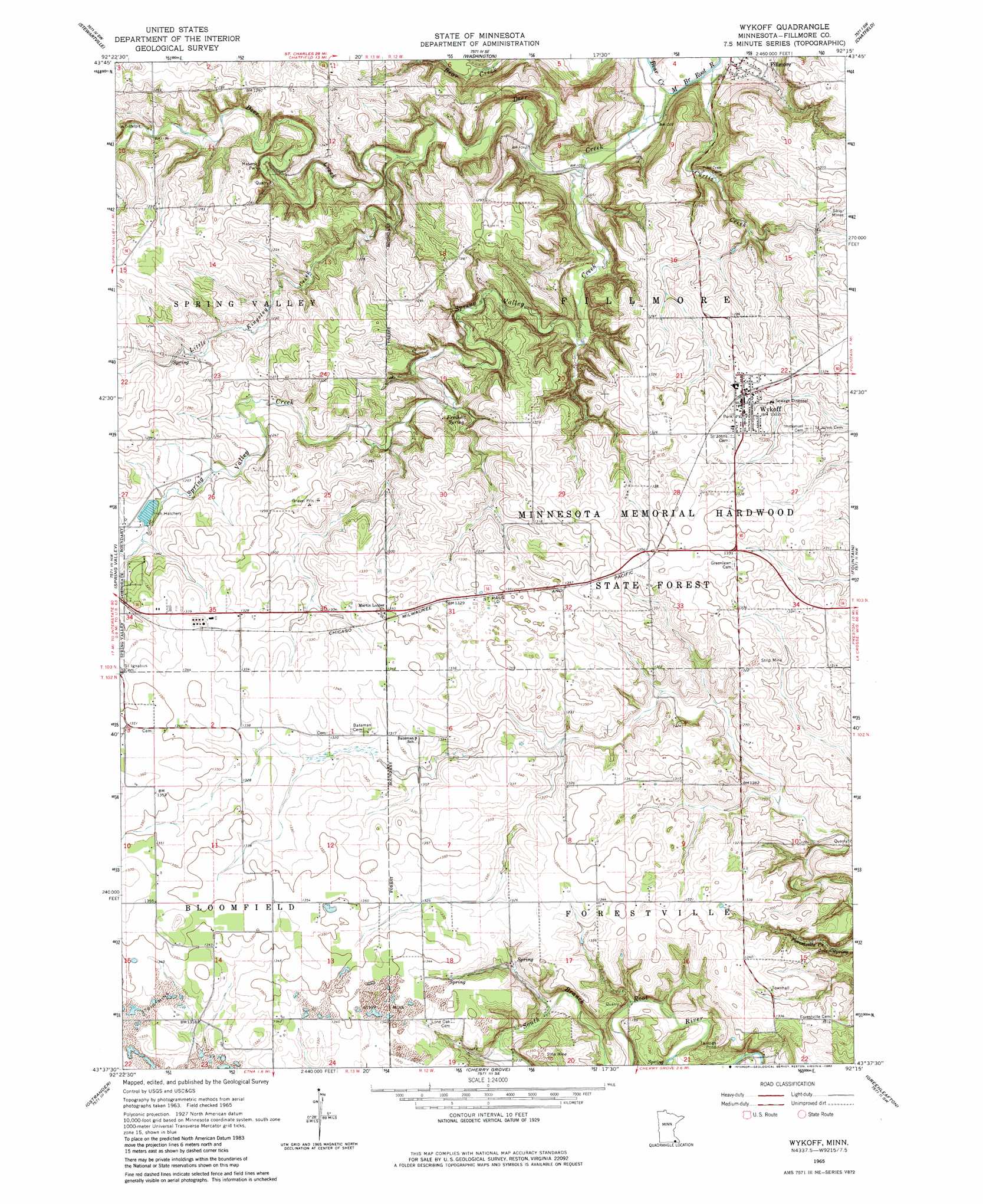
USGS Topo Quad 43092f3 - 1:24,000 scale
| Topo Map Name: | Wykoff |
| USGS Topo Quad ID: | 43092f3 |
| Print Size: | ca. 21 1/4" wide x 27" high |
| Southeast Coordinates: | 43.625° N latitude / 92.25° W longitude |
| Map Center Coordinates: | 43.6875° N latitude / 92.3125° W longitude |
| U.S. State: | MN |
| Filename: | o43092f3.jpg |
| Download Map JPG Image: | Wykoff topo map 1:24,000 scale |
| Map Type: | Topographic |
| Topo Series: | 7.5´ |
| Map Scale: | 1:24,000 |
| Source of Map Images: | United States Geological Survey (USGS) |
| Alternate Map Versions: |
Wykoff MN 1965, updated 1966 Download PDF Buy paper map Wykoff MN 1965, updated 1982 Download PDF Buy paper map Wykoff MN 2010 Download PDF Buy paper map Wykoff MN 2013 Download PDF Buy paper map Wykoff MN 2016 Download PDF Buy paper map |
1:24,000 Topo Quads surrounding Wykoff
Salem Corners |
Simpson |
Marion |
Eyota |
Saint Charles |
High Forest |
Stewartville |
Washington |
Chatfield |
Pilot Mound |
Grand Meadow |
Spring Valley |
Wykoff |
Fountain |
Preston |
Le Roy |
Ostrander |
Cherry Grove |
Greenleafton |
Harmony |
Mcintire |
Lime Springs Nw |
Lime Springs |
Cresco Nw |
Cresco Ne |
> Back to 43092e1 at 1:100,000 scale
> Back to 43092a1 at 1:250,000 scale
> Back to U.S. Topo Maps home
Wykoff topo map: Gazetteer
Wykoff: Forests
Minnesota Memorial Hardwood State Forest elevation 414m 1358′Wykoff: Parks
Masonic Park elevation 351m 1151′Meighen Store Historical Marker elevation 396m 1299′
Wykoff: Populated Places
Fillmore elevation 317m 1040′Freiheit Spring elevation 362m 1187′
Wykoff elevation 403m 1322′
Wykoff Mobile Home Park I elevation 403m 1322′
Wykoff Mobile Home Park II elevation 395m 1295′
Wykoff: Post Offices
Fillmore Post Office (historical) elevation 317m 1040′Wykoff Post Office elevation 403m 1322′
Wykoff: Streams
Bear Creek elevation 308m 1010′Curtis Creek elevation 308m 1010′
Deer Creek elevation 308m 1010′
Little Kingsley Creek elevation 329m 1079′
Spring Valley Creek elevation 314m 1030′
Wykoff digital topo map on disk
Buy this Wykoff topo map showing relief, roads, GPS coordinates and other geographical features, as a high-resolution digital map file on DVD: