Nora Springs Topo Map Iowa
To zoom in, hover over the map of Nora Springs
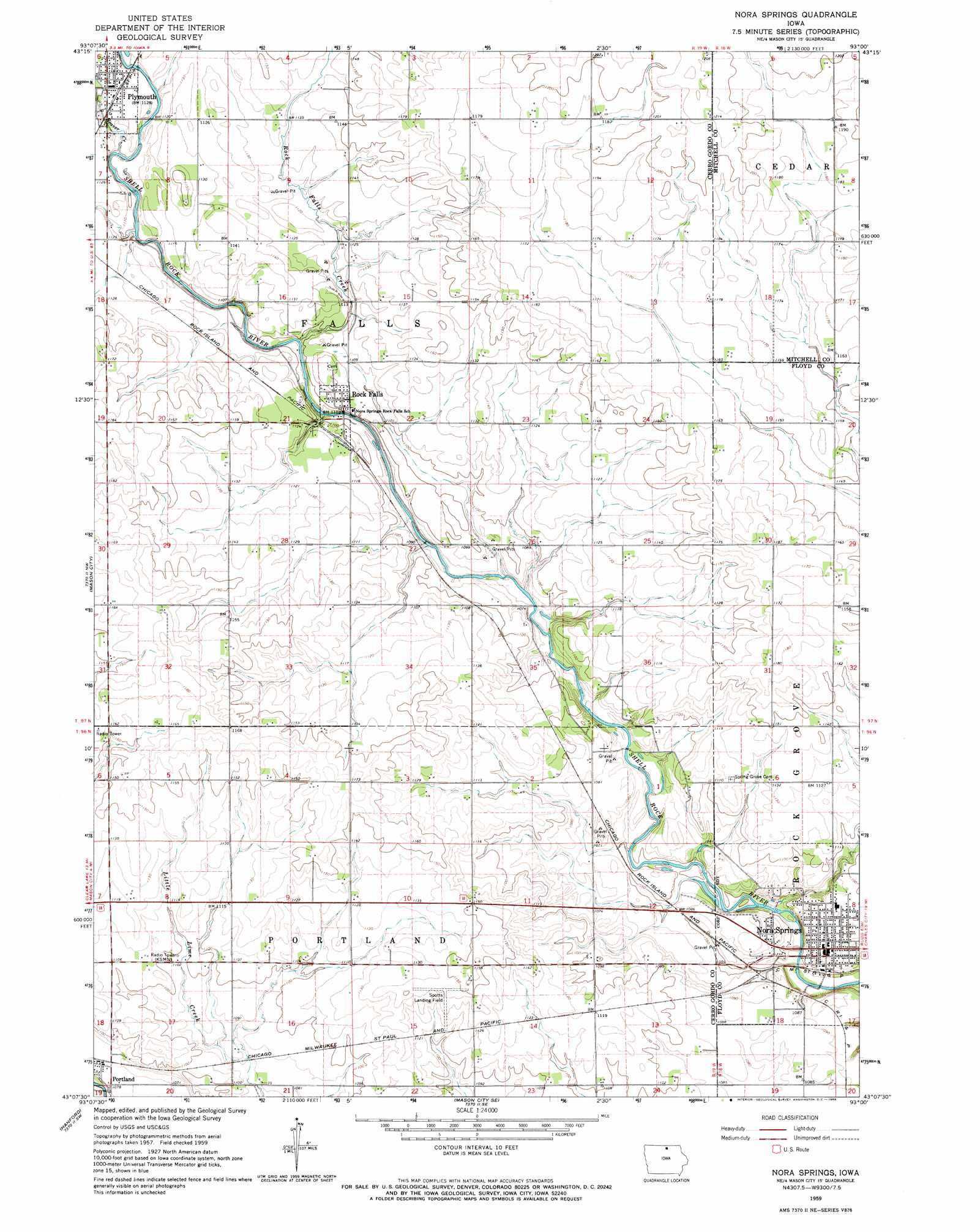
USGS Topo Quad 43093b1 - 1:24,000 scale
| Topo Map Name: | Nora Springs |
| USGS Topo Quad ID: | 43093b1 |
| Print Size: | ca. 21 1/4" wide x 27" high |
| Southeast Coordinates: | 43.125° N latitude / 93° W longitude |
| Map Center Coordinates: | 43.1875° N latitude / 93.0625° W longitude |
| U.S. State: | IA |
| Filename: | o43093b1.jpg |
| Download Map JPG Image: | Nora Springs topo map 1:24,000 scale |
| Map Type: | Topographic |
| Topo Series: | 7.5´ |
| Map Scale: | 1:24,000 |
| Source of Map Images: | United States Geological Survey (USGS) |
| Alternate Map Versions: |
Nora Springs IA 1959, updated 1966 Download PDF Buy paper map Nora Springs IA 2010 Download PDF Buy paper map Nora Springs IA 2013 Download PDF Buy paper map Nora Springs IA 2015 Download PDF Buy paper map |
1:24,000 Topo Quads surrounding Nora Springs
Fertile Ne |
Northwood |
Carpenter |
Saint Ansgar |
Stacyville |
Fertile Se |
Manly |
Grafton |
Osage Sw |
Osage |
Clear Lake East |
Mason City |
Nora Springs |
Rudd |
Orchard |
Burchinal |
Hanford |
Mason City Se |
Rockford |
Roseville |
Swaledale |
Sheffield |
Dougherty |
Aureola |
Greene |
> Back to 43093a1 at 1:100,000 scale
> Back to 43092a1 at 1:250,000 scale
> Back to U.S. Topo Maps home
Nora Springs topo map: Gazetteer
Nora Springs: Airports
Spotts Field elevation 347m 1138′Nora Springs: Bridges
Hawkeye Street Underpass elevation 321m 1053′Rock Falls Bridge elevation 328m 1076′
Nora Springs: Parks
White Wildlife Area elevation 340m 1115′Wilkinson Pioneer Park elevation 335m 1099′
Nora Springs: Populated Places
Nora Junction elevation 323m 1059′Nora Springs elevation 331m 1085′
Plymouth elevation 346m 1135′
Portland elevation 327m 1072′
Rock Falls elevation 336m 1102′
Wheelerwood elevation 360m 1181′
Nora Springs: Post Offices
Nora Springs Post Office elevation 330m 1082′Plymouth Post Office elevation 346m 1135′
Portland Post Office (historical) elevation 327m 1072′
Rock Falls Post Office (historical) elevation 336m 1102′
Nora Springs: Streams
Beaver Creek elevation 335m 1099′Rock Falls Creek elevation 332m 1089′
Nora Springs digital topo map on disk
Buy this Nora Springs topo map showing relief, roads, GPS coordinates and other geographical features, as a high-resolution digital map file on DVD: