Glenville Topo Map Minnesota
To zoom in, hover over the map of Glenville
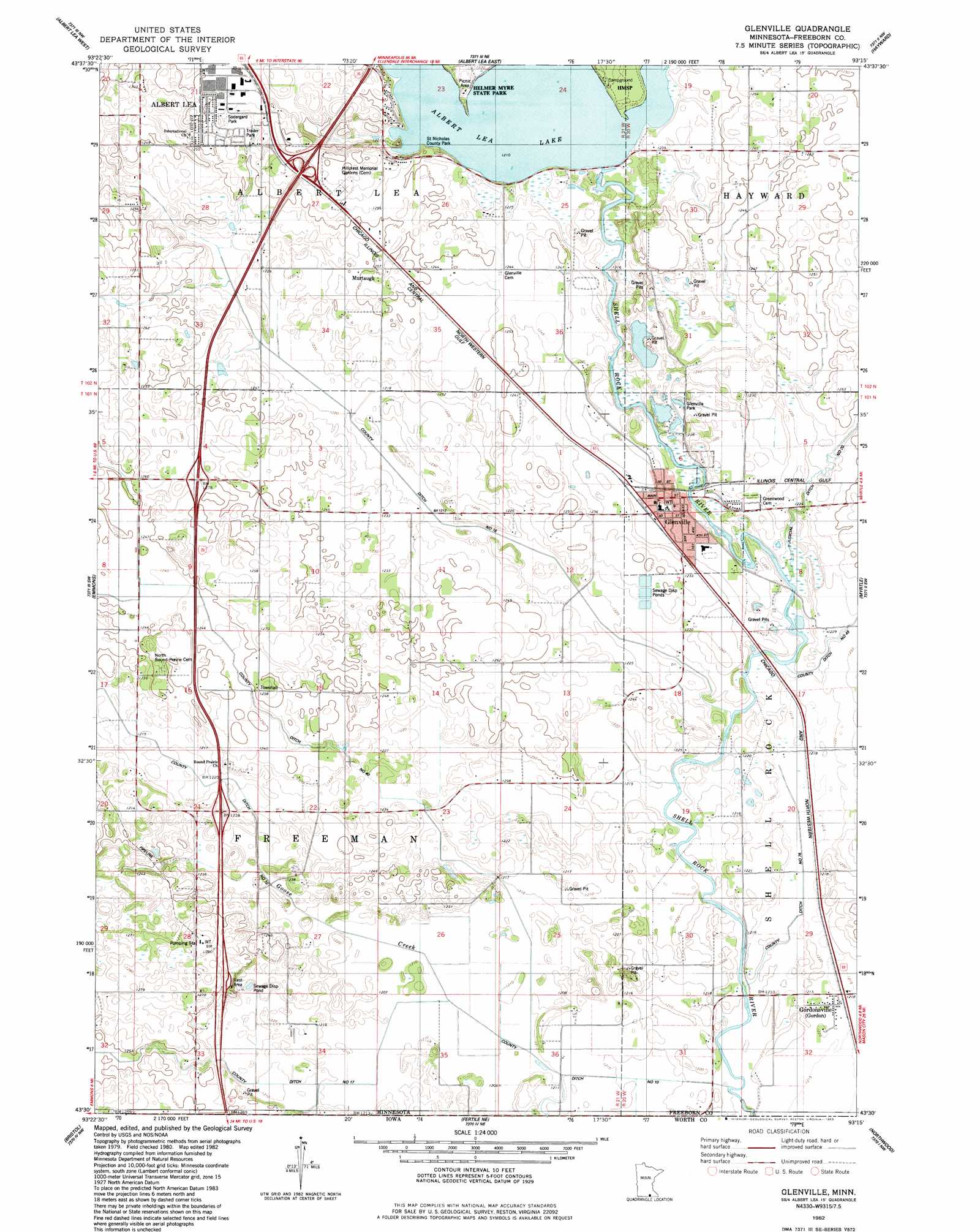
USGS Topo Quad 43093e3 - 1:24,000 scale
| Topo Map Name: | Glenville |
| USGS Topo Quad ID: | 43093e3 |
| Print Size: | ca. 21 1/4" wide x 27" high |
| Southeast Coordinates: | 43.5° N latitude / 93.25° W longitude |
| Map Center Coordinates: | 43.5625° N latitude / 93.3125° W longitude |
| U.S. State: | MN |
| Filename: | o43093e3.jpg |
| Download Map JPG Image: | Glenville topo map 1:24,000 scale |
| Map Type: | Topographic |
| Topo Series: | 7.5´ |
| Map Scale: | 1:24,000 |
| Source of Map Images: | United States Geological Survey (USGS) |
| Alternate Map Versions: |
Glenville MN 1982, updated 1983 Download PDF Buy paper map Glenville MN 2010 Download PDF Buy paper map Glenville MN 2013 Download PDF Buy paper map Glenville MN 2016 Download PDF Buy paper map |
1:24,000 Topo Quads surrounding Glenville
Freeborn |
Hartland |
Ellendale |
Hollandale |
Blooming Prairie |
Alden |
Albert Lea West |
Albert Lea East |
Hayward |
Austin West |
Conger |
Emmons |
Glenville |
Myrtle |
London |
Lake Mills |
Bristol |
Fertile Ne |
Northwood |
Carpenter |
Pilot Knob |
Fertile |
Fertile Se |
Manly |
Grafton |
> Back to 43093e1 at 1:100,000 scale
> Back to 43092a1 at 1:250,000 scale
> Back to U.S. Topo Maps home
Glenville topo map: Gazetteer
Glenville: Airports
Air-AG Airport elevation 378m 1240′Glenville: Canals
County Ditch Number Forty elevation 372m 1220′County Ditch Number Seventeen elevation 378m 1240′
County Ditch Number Seventysix elevation 369m 1210′
County Ditch Number Sixteen elevation 369m 1210′
County Ditch Number Ten elevation 369m 1210′
Glenville: Crossings
Interchange 2 elevation 369m 1210′Interchange 5 elevation 384m 1259′
Interchange 8 elevation 394m 1292′
Glenville: Dams
Albert Lea Lake Dam elevation 380m 1246′Glenville: Parks
Big Island State Park elevation 375m 1230′Minnesota's Roads Historical Marker elevation 385m 1263′
Saint Nicholas County Park elevation 379m 1243′
Sodergard Park elevation 389m 1276′
Glenville: Populated Places
Glenville elevation 376m 1233′Gordonsville elevation 371m 1217′
Murtaugh elevation 384m 1259′
Rainbow Terrace Mobile Home Park elevation 391m 1282′
Stoney Creek Estates elevation 390m 1279′
Glenville: Post Offices
Glenville Post Office elevation 376m 1233′Gordonsville Post Office (historical) elevation 371m 1217′
Glenville: Reservoirs
Albert Lea Lake elevation 369m 1210′Glenville: Streams
Goose Creek elevation 369m 1210′Glenville: Swamps
Grass Lake elevation 368m 1207′Glenville digital topo map on disk
Buy this Glenville topo map showing relief, roads, GPS coordinates and other geographical features, as a high-resolution digital map file on DVD: