Emmetsburg Topo Map Iowa
To zoom in, hover over the map of Emmetsburg
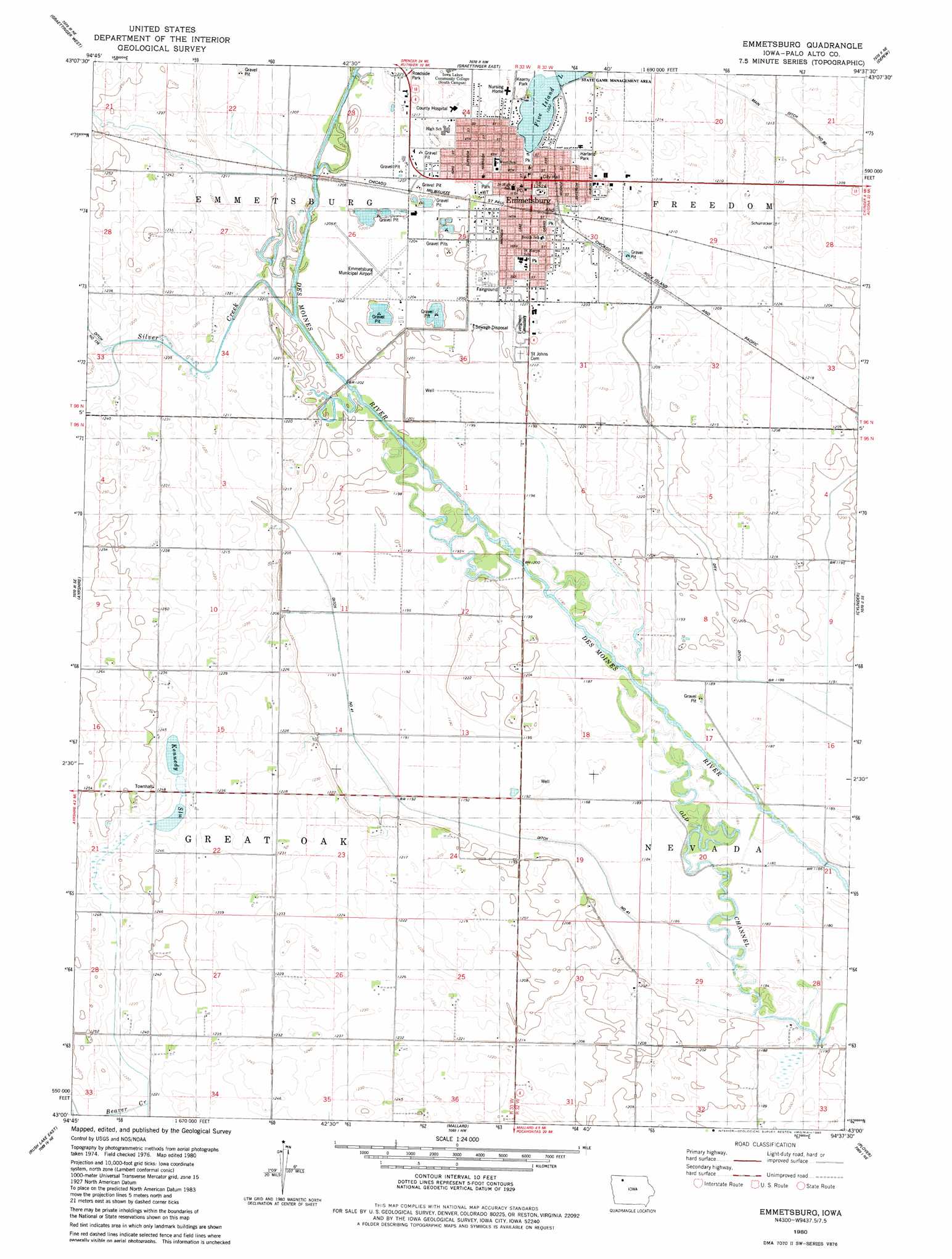
USGS Topo Quad 43094a6 - 1:24,000 scale
| Topo Map Name: | Emmetsburg |
| USGS Topo Quad ID: | 43094a6 |
| Print Size: | ca. 21 1/4" wide x 27" high |
| Southeast Coordinates: | 43° N latitude / 94.625° W longitude |
| Map Center Coordinates: | 43.0625° N latitude / 94.6875° W longitude |
| U.S. State: | IA |
| Filename: | o43094a6.jpg |
| Download Map JPG Image: | Emmetsburg topo map 1:24,000 scale |
| Map Type: | Topographic |
| Topo Series: | 7.5´ |
| Map Scale: | 1:24,000 |
| Source of Map Images: | United States Geological Survey (USGS) |
| Alternate Map Versions: |
Emmetsburg IA 1980, updated 1980 Download PDF Buy paper map Emmetsburg IA 2010 Download PDF Buy paper map Emmetsburg IA 2013 Download PDF Buy paper map Emmetsburg IA 2015 Download PDF Buy paper map |
1:24,000 Topo Quads surrounding Emmetsburg
Terril |
Wallingford |
Ingham Lake |
Ringsted |
Seneca |
Ruthven |
Graettinger West |
Graettinger East |
Depew |
Fenton |
Silver Lake |
Ayrshire |
Emmetsburg |
Cylinder |
Whittemore |
Rush Lake West |
Rush Lake East |
Mallard |
Plover |
Unique |
Albert City |
Laurens |
Havelock |
Rolfe |
Bradgate |
> Back to 43094a1 at 1:100,000 scale
> Back to 43094a1 at 1:250,000 scale
> Back to U.S. Topo Maps home
Emmetsburg topo map: Gazetteer
Emmetsburg: Airports
Emmetsburg Municipal Airport elevation 367m 1204′Emmetsburg: Canals
Ditch Number 41 elevation 361m 1184′Dry Ditch elevation 363m 1190′
Emmetsburg: Channels
Old Channel elevation 360m 1181′Emmetsburg: Lakes
Kennedy Slu elevation 378m 1240′Emmetsburg: Parks
Brushy Bayou Wildlife Area elevation 360m 1181′Dragoon Trail in Palo Alto County Historical Marker elevation 373m 1223′
Grand Army of Republic Monument Historical Marker elevation 373m 1223′
Harland Park elevation 373m 1223′
Kearny Park elevation 376m 1233′
Pioneer Walnut Log Cabin Historical Marker elevation 374m 1227′
Robert Emmet Statue elevation 381m 1250′
Watson Heritage Area elevation 365m 1197′
Emmetsburg: Populated Places
Emmetsburg elevation 377m 1236′Emmetsburg: Post Offices
Emmetsburg Post Office elevation 379m 1243′Great Oak Post Office (historical) elevation 372m 1220′
Paoli Post Office (historical) elevation 375m 1230′
Soda Bar Post Office (historical) elevation 362m 1187′
Emmetsburg: Streams
Silver Creek elevation 368m 1207′Emmetsburg digital topo map on disk
Buy this Emmetsburg topo map showing relief, roads, GPS coordinates and other geographical features, as a high-resolution digital map file on DVD: