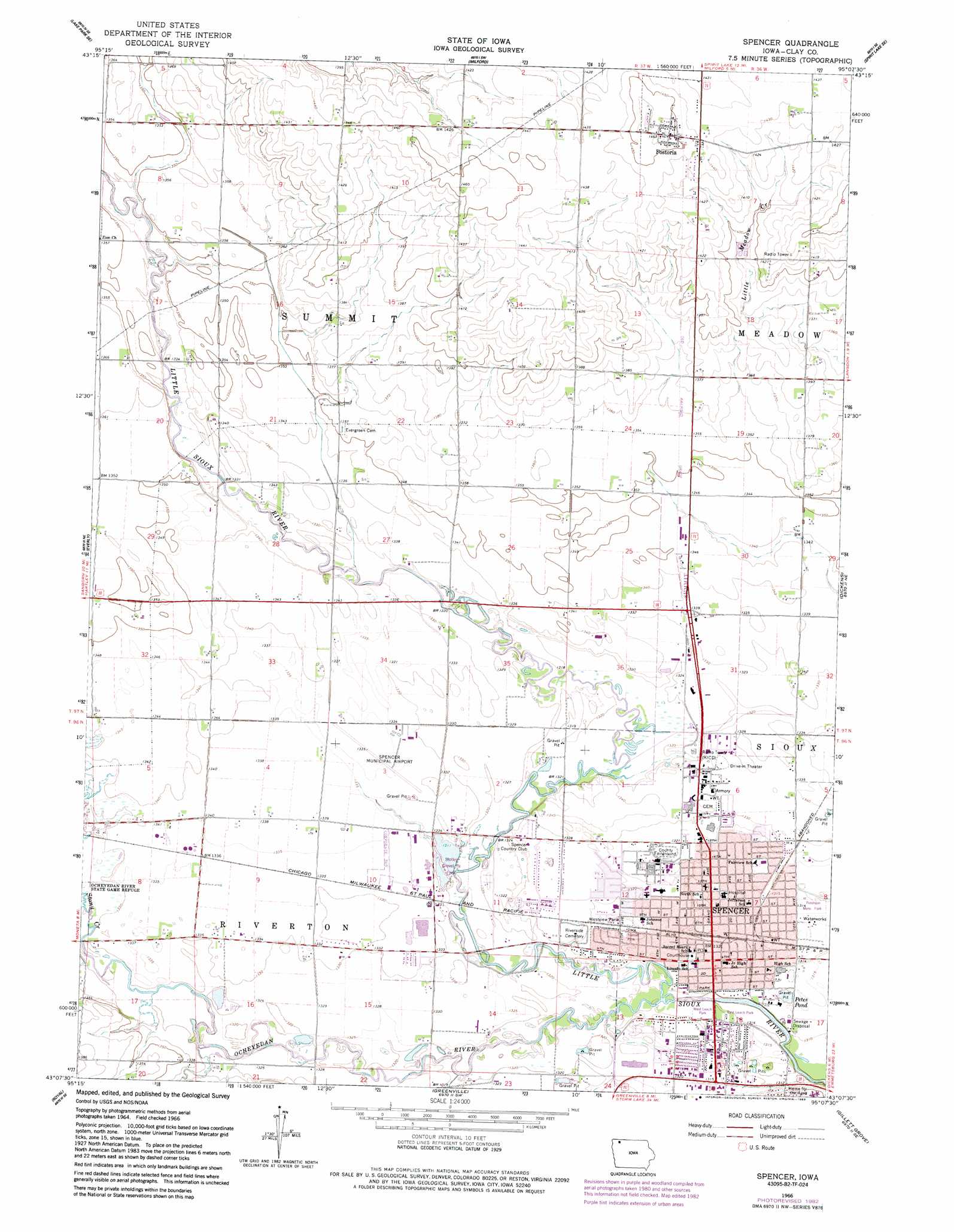
Spencer Topo Map Iowa
To zoom in, hover over the map of Spencer
USGS Topo Quad 43095b2 - 1:24,000 scale
| Topo Map Name: | Spencer |
| USGS Topo Quad ID: | 43095b2 |
| Print Size: | ca. 21 1/4" wide x 27" high |
| Southeast Coordinates: | 43.125° N latitude / 95.125° W longitude |
| Map Center Coordinates: | 43.1875° N latitude / 95.1875° W longitude |
| U.S. State: | IA |
| Filename: | o43095b2.jpg |
| Download Map JPG Image: | Spencer topo map 1:24,000 scale |
| Map Type: | Topographic |
| Topo Series: | 7.5´ |
| Map Scale: | 1:24,000 |
| Source of Map Images: | United States Geological Survey (USGS) |
| Alternate Map Versions: |
Spencer IA 1966, updated 1967 Download PDF Buy paper map Spencer IA 1966, updated 1983 Download PDF Buy paper map Spencer IA 2010 Download PDF Buy paper map Spencer IA 2013 Download PDF Buy paper map Spencer IA 2015 Download PDF Buy paper map |
1:24,000 Topo Quads surrounding Spencer
Harris |
Lake Park |
Okoboji |
Spirit Lake |
Superior |
May City |
Lake Park Se |
Milford |
Spirit Lake Se |
Terril |
Hartley |
Everly |
Spencer |
Dickens |
Ruthven |
Hartley Sw |
Royal |
Creenville |
Gillett Grove |
Silver Lake |
Sutherland East |
Peterson |
Sioux Rapids |
Webb |
Rush Lake West |
> Back to 43095a1 at 1:100,000 scale
> Back to 43094a1 at 1:250,000 scale
> Back to U.S. Topo Maps home
Spencer topo map: Gazetteer
Spencer: Airports
Spencer Municipal Airport elevation 407m 1335′Spencer Municipal Hospital Heliport elevation 402m 1318′
Spencer: Bridges
Little Sioux River Bridge elevation 400m 1312′Spencer: Lakes
Petes Pond elevation 401m 1315′Spencer: Parks
Bob Howe - Thunder Bridge Wildlife Refuge elevation 400m 1312′C Earl Page Park elevation 404m 1325′
Cardinal Field elevation 401m 1315′
East Leach Park elevation 399m 1309′
Fairview Park elevation 401m 1315′
First Post Office, Church, School Historical Marker elevation 402m 1318′
Miracle on Fourth Street Playground elevation 399m 1309′
North School Park elevation 402m 1318′
Reiter Wildlife Area elevation 401m 1315′
Stolley Gravel Pit Park elevation 401m 1315′
Sunset Park elevation 402m 1318′
West Leach Park elevation 397m 1302′
Westview Park elevation 403m 1322′
Yellowthroat Wildlife Area elevation 404m 1325′
Spencer: Populated Places
Birchwood Estates elevation 408m 1338′Fostoria elevation 444m 1456′
Spencer elevation 400m 1312′
Spencer: Post Offices
Fostoria Post Office elevation 443m 1453′Spencer Post Office elevation 402m 1318′
Summit Post Office (historical) elevation 418m 1371′
Spencer: Streams
Ocheyedan River elevation 397m 1302′Stony Creek elevation 406m 1332′
Spencer: Trails
Spencer Recreation Trail elevation 400m 1312′Spencer digital topo map on disk
Buy this Spencer topo map showing relief, roads, GPS coordinates and other geographical features, as a high-resolution digital map file on DVD: