Bingham Lake Topo Map Minnesota
To zoom in, hover over the map of Bingham Lake
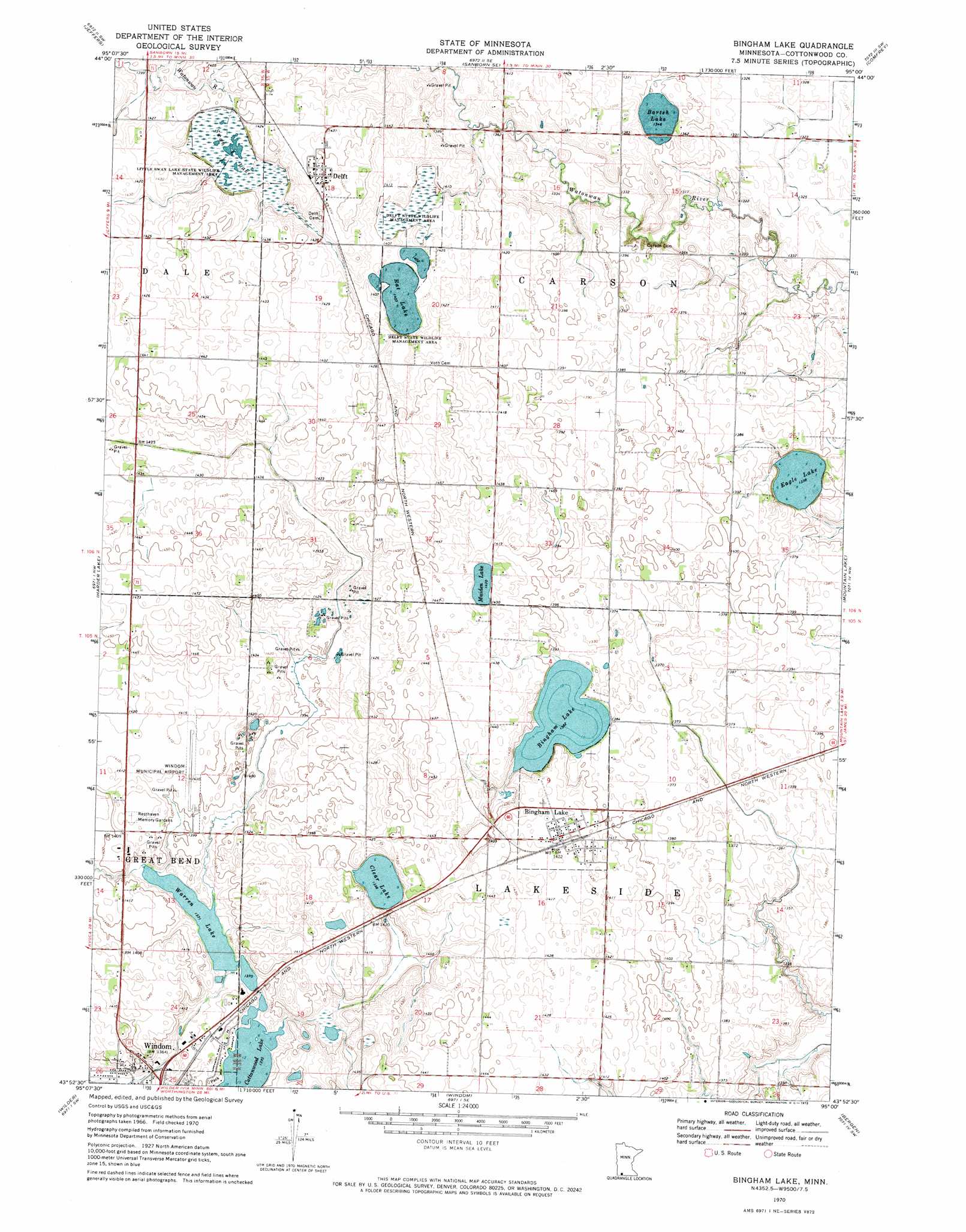
USGS Topo Quad 43095h1 - 1:24,000 scale
| Topo Map Name: | Bingham Lake |
| USGS Topo Quad ID: | 43095h1 |
| Print Size: | ca. 21 1/4" wide x 27" high |
| Southeast Coordinates: | 43.875° N latitude / 95° W longitude |
| Map Center Coordinates: | 43.9375° N latitude / 95.0625° W longitude |
| U.S. State: | MN |
| Filename: | o43095h1.jpg |
| Download Map JPG Image: | Bingham Lake topo map 1:24,000 scale |
| Map Type: | Topographic |
| Topo Series: | 7.5´ |
| Map Scale: | 1:24,000 |
| Source of Map Images: | United States Geological Survey (USGS) |
| Alternate Map Versions: |
Bingham Lake MN 1970, updated 1972 Download PDF Buy paper map Bingham Lake MN 2010 Download PDF Buy paper map Bingham Lake MN 2013 Download PDF Buy paper map Bingham Lake MN 2016 Download PDF Buy paper map |
1:24,000 Topo Quads surrounding Bingham Lake
Lamberton |
Sanborn |
Sanborn Ne |
Springfield |
Leavenworth |
Storden |
Jeffers |
Sanborn Se |
Comfrey |
Darfur |
Heron Lake Ne |
Harder Lake |
Bingham Lake |
Mountain Lake |
Butterfield |
Heron Lake |
Wilder |
Windom |
Bergen |
Mountain Lake Se |
Okabena |
Lakefield |
Lakefield Ne |
Jackson Nw |
Alpha |
> Back to 43095e1 at 1:100,000 scale
> Back to 43094a1 at 1:250,000 scale
> Back to U.S. Topo Maps home
Bingham Lake topo map: Gazetteer
Bingham Lake: Airports
Windom Municipal Airport elevation 429m 1407′Bingham Lake: Dams
Eagle Lake Dam elevation 409m 1341′Warren Lake Dam elevation 433m 1420′
Bingham Lake: Lakes
Barish Lake elevation 410m 1345′Bingham Lake elevation 421m 1381′
Clear Lake elevation 426m 1397′
Cottonwood Lake elevation 418m 1371′
Eagle Lake elevation 408m 1338′
Maiden Lake elevation 433m 1420′
Rat Lake elevation 428m 1404′
Warren Lake elevation 423m 1387′
Bingham Lake: Parks
Abby Park elevation 424m 1391′Delft State Wildlife Management Area elevation 427m 1400′
Little Swan Lake State Wildlife Management A elevation 426m 1397′
Tegels Park elevation 423m 1387′
Bingham Lake: Populated Places
Bingham Lake elevation 433m 1420′Delft elevation 443m 1453′
Bingham Lake: Post Offices
Bingham Post Office elevation 433m 1420′Delft Post Office elevation 443m 1453′
Bingham Lake: Reservoirs
Eagle Lake elevation 409m 1341′Warren Lake elevation 433m 1420′
Bingham Lake: Swamps
Swan Lake elevation 424m 1391′Bingham Lake digital topo map on disk
Buy this Bingham Lake topo map showing relief, roads, GPS coordinates and other geographical features, as a high-resolution digital map file on DVD: