Canton Topo Map South Dakota
To zoom in, hover over the map of Canton
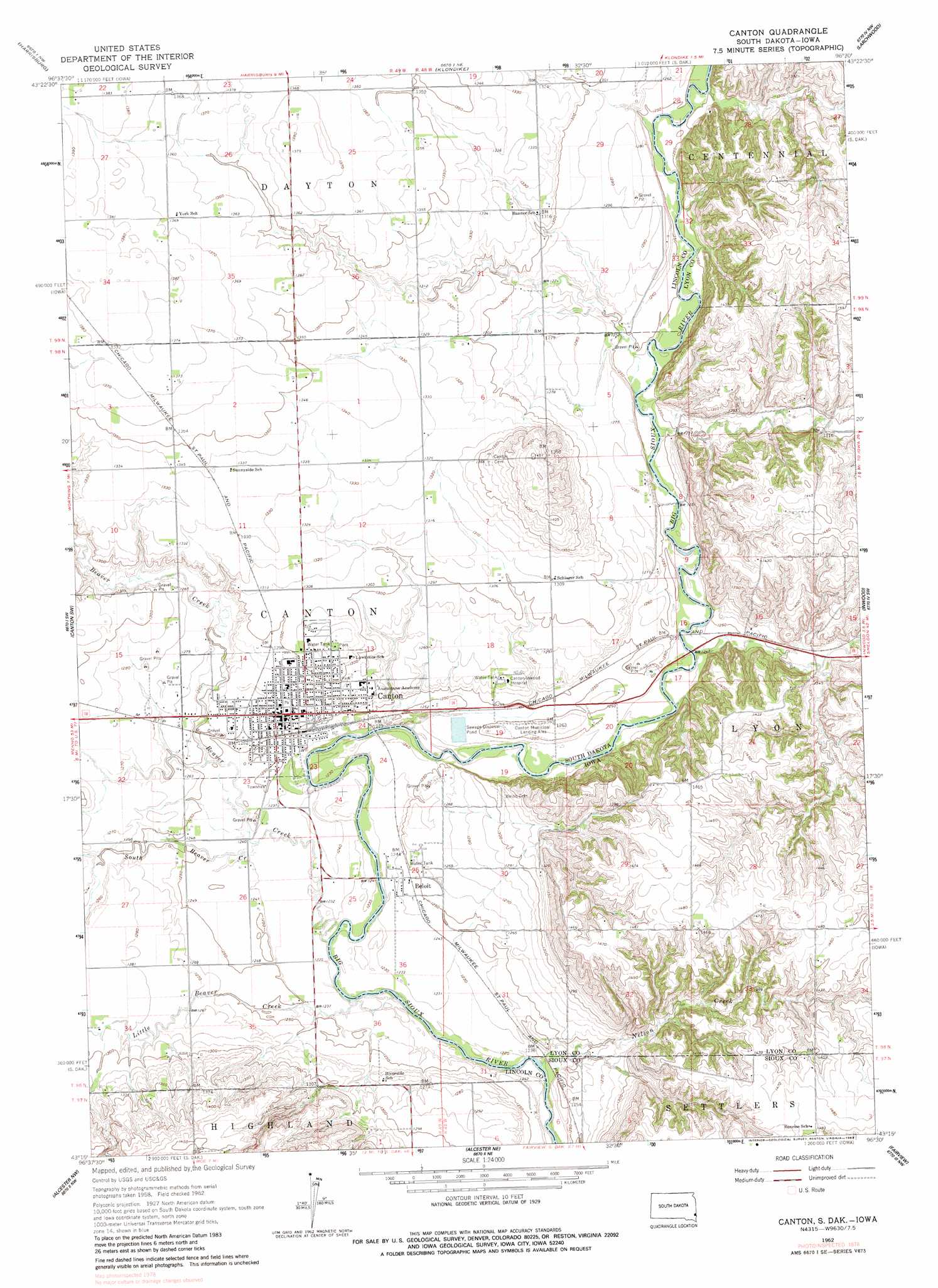
USGS Topo Quad 43096c5 - 1:24,000 scale
| Topo Map Name: | Canton |
| USGS Topo Quad ID: | 43096c5 |
| Print Size: | ca. 21 1/4" wide x 27" high |
| Southeast Coordinates: | 43.25° N latitude / 96.5° W longitude |
| Map Center Coordinates: | 43.3125° N latitude / 96.5625° W longitude |
| U.S. States: | SD, IA |
| Filename: | o43096c5.jpg |
| Download Map JPG Image: | Canton topo map 1:24,000 scale |
| Map Type: | Topographic |
| Topo Series: | 7.5´ |
| Map Scale: | 1:24,000 |
| Source of Map Images: | United States Geological Survey (USGS) |
| Alternate Map Versions: |
Canton SD 1962, updated 1964 Download PDF Buy paper map Canton SD 1962, updated 1983 Download PDF Buy paper map Canton SD 2010 Download PDF Buy paper map Canton SD 2012 Download PDF Buy paper map Canton SD 2015 Download PDF Buy paper map |
1:24,000 Topo Quads surrounding Canton
Sioux Falls West |
Sioux Falls East |
Brandon |
Valley Springs |
Hills |
Tea |
Harrisburg |
Klondike |
Larchwood |
Lester |
Worthing |
Canton Sw |
Canton |
Inwood |
Alvord |
Beresford Ne |
Alcester Nw |
Alcester Ne |
Fairview |
Rock Valley |
Beresford |
Alcester |
Alcester Se |
Hawarden North |
Lebanon |
> Back to 43096a1 at 1:100,000 scale
> Back to 43096a1 at 1:250,000 scale
> Back to U.S. Topo Maps home
Canton topo map: Gazetteer
Canton: Airports
Canton Municipal Airport elevation 394m 1292′Canton: Areas
Big Sioux Wildlife Public Hunting Area elevation 430m 1410′Canton: Parks
Big Sioux River Wildlife Area - Kroger Tract elevation 437m 1433′Big Sioux River Wildlife Area - Nelson Tract elevation 411m 1348′
Big Sioux River Wildlife Area - Olson Tract elevation 410m 1345′
Canton: Populated Places
Beloit elevation 379m 1243′Canton elevation 387m 1269′
Canton: Post Offices
Beloit Post Office (historical) elevation 379m 1243′Canton: Streams
Beaver Creek elevation 372m 1220′Little Beaver Creek elevation 369m 1210′
Nelson Creek elevation 369m 1210′
South Beaver Creek elevation 376m 1233′
Canton: Summits
Canton Mounds elevation 430m 1410′Canton digital topo map on disk
Buy this Canton topo map showing relief, roads, GPS coordinates and other geographical features, as a high-resolution digital map file on DVD:
Eastern North Dakota & Eastern South Dakota
Buy digital topo maps: Eastern North Dakota & Eastern South Dakota