Ellsworth Topo Map Minnesota
To zoom in, hover over the map of Ellsworth
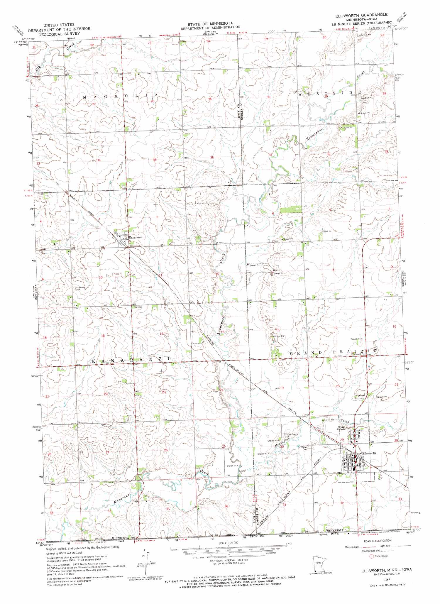
USGS Topo Quad 43096e1 - 1:24,000 scale
| Topo Map Name: | Ellsworth |
| USGS Topo Quad ID: | 43096e1 |
| Print Size: | ca. 21 1/4" wide x 27" high |
| Southeast Coordinates: | 43.5° N latitude / 96° W longitude |
| Map Center Coordinates: | 43.5625° N latitude / 96.0625° W longitude |
| U.S. States: | MN, IA |
| Filename: | o43096e1.jpg |
| Download Map JPG Image: | Ellsworth topo map 1:24,000 scale |
| Map Type: | Topographic |
| Topo Series: | 7.5´ |
| Map Scale: | 1:24,000 |
| Source of Map Images: | United States Geological Survey (USGS) |
| Alternate Map Versions: |
Ellsworth MN 1967, updated 1969 Download PDF Buy paper map Ellsworth MN 2010 Download PDF Buy paper map Ellsworth MN 2013 Download PDF Buy paper map Ellsworth MN 2016 Download PDF Buy paper map |
1:24,000 Topo Quads surrounding Ellsworth
Jasper Se |
Edgerton South |
Kenneth |
Slayton Sw |
Wilmont |
Hills Ne |
Luverne |
Magnolia |
Adrian |
Adrian Ne |
Hills |
Ash Creek |
Ellsworth |
Adrian Sw |
Rushmore |
Lester |
Rock Rapids |
Edna |
Little Rock |
Sibley West |
Alvord |
Doon |
George West |
George East |
Ashton |
> Back to 43096e1 at 1:100,000 scale
> Back to 43096a1 at 1:250,000 scale
> Back to U.S. Topo Maps home
Ellsworth topo map: Gazetteer
Ellsworth: Parks
Aid Pit State Wildlife Management Area elevation 458m 1502′Ells Pit State Wildlife Management Area elevation 445m 1459′
Ellsworth City Park elevation 442m 1450′
Sherwood State Wildlife Management Area elevation 451m 1479′
Ellsworth: Populated Places
Ellsworth elevation 442m 1450′Kanaranzi elevation 458m 1502′
Ellsworth: Post Offices
Ellsworth Post Office elevation 442m 1450′Kanaranzi Post Office elevation 458m 1502′
Ellsworth: Streams
Norwegian Creek elevation 426m 1397′Ellsworth digital topo map on disk
Buy this Ellsworth topo map showing relief, roads, GPS coordinates and other geographical features, as a high-resolution digital map file on DVD:
Eastern North Dakota & Eastern South Dakota
Buy digital topo maps: Eastern North Dakota & Eastern South Dakota