Presho 4 Nw Topo Map South Dakota
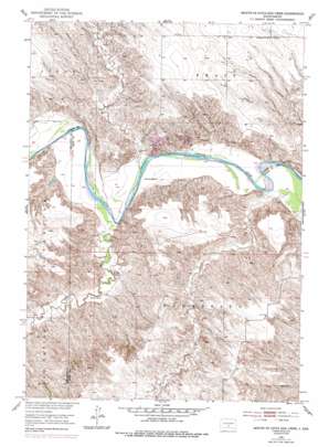
To zoom in, hover over the map of Presho 4 Nw
USGS Topo Quad 43100f2 - 1:24,000 scale
| Topo Map Name: | Presho 4 Nw |
| USGS Topo Quad ID: | 43100f2 |
| Print Size: | ca. 21 1/4" wide x 27" high |
| Southeast Coordinates: | 43.625° N latitude / 100.125° W longitude |
| Map Center Coordinates: | 43.6875° N latitude / 100.1875° W longitude |
| U.S. State: | SD |
| Filename: | o43100f2.jpg |
| Download Map JPG Image: | Presho 4 Nw topo map 1:24,000 scale |
| Map Type: | Topographic |
| Topo Series: | 7.5´ |
| Map Scale: | 1:24,000 |
| Source of Map Images: | United States Geological Survey (USGS) |
| Alternate Map Versions: |
Presho 4 NW SD 1951, updated 1953 Download PDF Buy paper map Presho 4 NW SD 1951, updated 1979 Download PDF Buy paper map Mouth of Little Dog Creek SD 1951, updated 1994 Download PDF Buy paper map Mouth of Little Dog Creek SD 2012 Download PDF Buy paper map Mouth of Little Dog Creek SD 2015 Download PDF Buy paper map |
1:24,000 Topo Quads surrounding Presho 4 Nw
> Back to 43100e1 at 1:100,000 scale
> Back to 43100a1 at 1:250,000 scale
> Back to U.S. Topo Maps home
Presho 4 Nw topo map: Gazetteer
Presho 4 Nw: Dams
Dale Swedland Number 1 Dam elevation 531m 1742′J Moeller Dam elevation 578m 1896′
White River Grazing Association Number 3 Dam elevation 500m 1640′
Presho 4 Nw: Streams
Little Dog Creek elevation 491m 1610′Oak Creek elevation 496m 1627′
Sedlano Creek elevation 494m 1620′
Presho 4 Nw digital topo map on disk
Buy this Presho 4 Nw topo map showing relief, roads, GPS coordinates and other geographical features, as a high-resolution digital map file on DVD:
Eastern North Dakota & Eastern South Dakota
Buy digital topo maps: Eastern North Dakota & Eastern South Dakota


