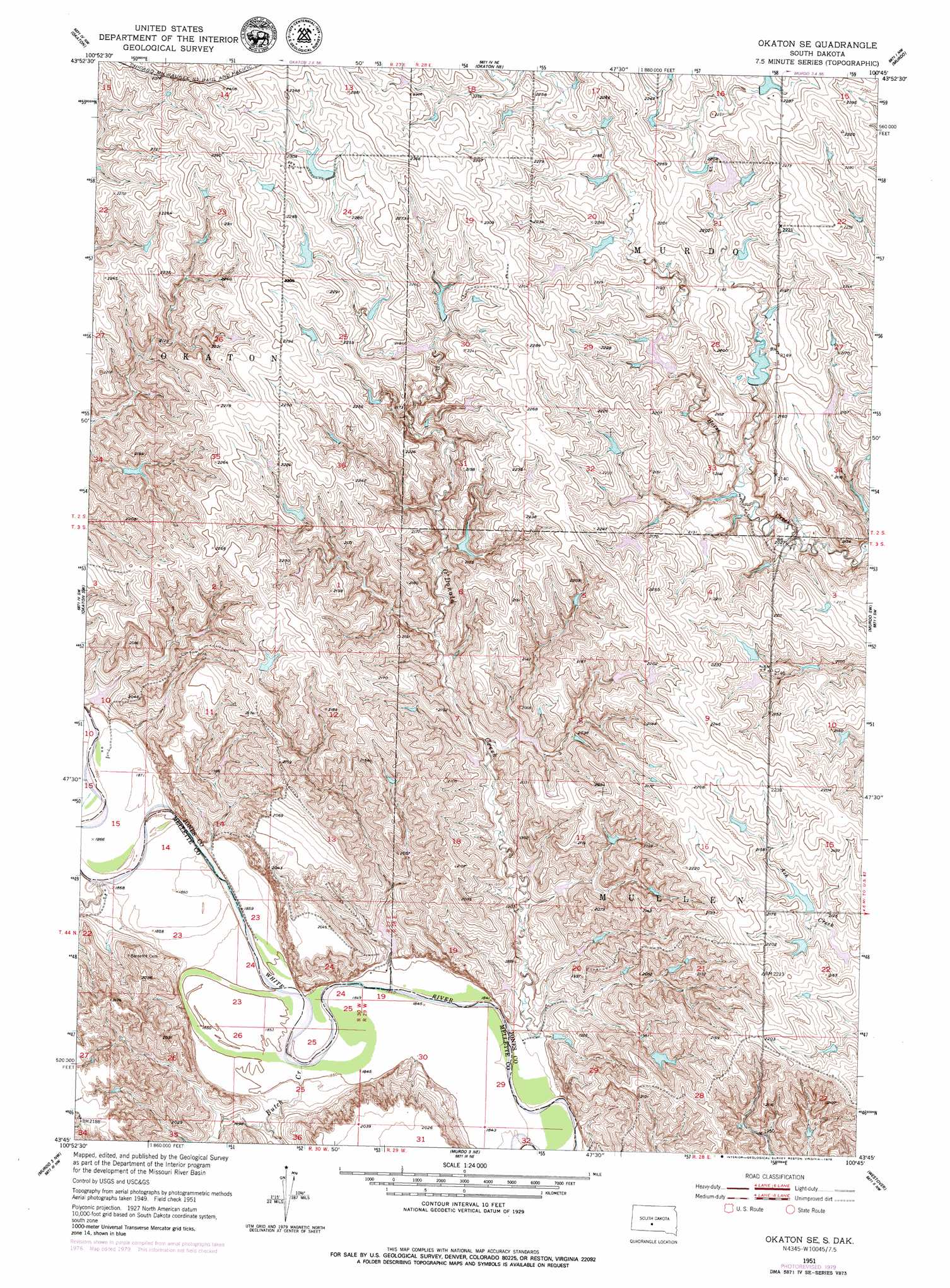
Okaton Se Topo Map South Dakota
To zoom in, hover over the map of Okaton Se
USGS Topo Quad 43100g7 - 1:24,000 scale
| Topo Map Name: | Okaton Se |
| USGS Topo Quad ID: | 43100g7 |
| Print Size: | ca. 21 1/4" wide x 27" high |
| Southeast Coordinates: | 43.75° N latitude / 100.75° W longitude |
| Map Center Coordinates: | 43.8125° N latitude / 100.8125° W longitude |
| U.S. State: | SD |
| Filename: | o43100g7.jpg |
| Download Map JPG Image: | Okaton Se topo map 1:24,000 scale |
| Map Type: | Topographic |
| Topo Series: | 7.5´ |
| Map Scale: | 1:24,000 |
| Source of Map Images: | United States Geological Survey (USGS) |
| Alternate Map Versions: |
Okaton SE SD 1951, updated 1953 Download PDF Buy paper map Okaton SE SD 1951, updated 1979 Download PDF Buy paper map Okaton SE SD 2012 Download PDF Buy paper map Okaton SE SD 2015 Download PDF Buy paper map |
1:24,000 Topo Quads surrounding Okaton Se
Midland Se |
Capa |
Capa Se |
Wendte Sw |
Wendte Se |
Stamford |
Okaton |
Okaton Ne |
Murdo |
Draper |
Stamford Se |
Okaton Sw |
Okaton Se |
Murdo Sw |
Murdo Se |
Cedar Butte Ne |
Murdo 3 Nw |
Murdo 3 Ne |
Westover |
White River Ne |
Cedarbutte |
Murdo 3 Sw |
White River West |
White River East |
White River Se |
> Back to 43100e1 at 1:100,000 scale
> Back to 43100a1 at 1:250,000 scale
> Back to U.S. Topo Maps home
Okaton Se topo map: Gazetteer
Okaton Se: Dams
Brost Number 1 Dam elevation 581m 1906′Brost Number 10 Dam elevation 612m 2007′
Brost Number 2 Dam elevation 669m 2194′
Brost Number 3 Dam elevation 605m 1984′
Brost Number 4 Dam elevation 594m 1948′
Brost Number 5 Dam elevation 669m 2194′
Brost Number 6 Dam elevation 659m 2162′
Dykstra Number 1 Dam elevation 674m 2211′
Dykstra Number 10 Dam elevation 613m 2011′
Dykstra Number 11 Dam elevation 590m 1935′
Dykstra Number 12 Dam elevation 589m 1932′
Dykstra Number 14 Dam elevation 666m 2185′
Dykstra Number 2 Dam elevation 653m 2142′
Dykstra Number 3 Dam elevation 655m 2148′
Dykstra Number 4 Dam elevation 642m 2106′
Dykstra Number 5 Dam elevation 667m 2188′
Dykstra Number 6 Dam elevation 635m 2083′
Dykstra Number 7 Dam elevation 660m 2165′
Dykstra Number 8 Dam elevation 662m 2171′
Dykstra Number 9 Dam elevation 647m 2122′
Hix Number 1 Dam elevation 572m 1876′
Richardson Number 2 Dam elevation 630m 2066′
Tornow Number 1 Dam elevation 674m 2211′
Okaton Se: Streams
Butch Creek elevation 561m 1840′O'Donald Creek elevation 559m 1833′
Roundup Creek elevation 567m 1860′
Okaton Se digital topo map on disk
Buy this Okaton Se topo map showing relief, roads, GPS coordinates and other geographical features, as a high-resolution digital map file on DVD:
Eastern North Dakota & Eastern South Dakota
Buy digital topo maps: Eastern North Dakota & Eastern South Dakota