Okaton Sw Topo Map South Dakota
To zoom in, hover over the map of Okaton Sw
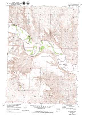
USGS Topo Quad 43100g8 - 1:24,000 scale
| Topo Map Name: | Okaton Sw |
| USGS Topo Quad ID: | 43100g8 |
| Print Size: | ca. 21 1/4" wide x 27" high |
| Southeast Coordinates: | 43.75° N latitude / 100.875° W longitude |
| Map Center Coordinates: | 43.8125° N latitude / 100.9375° W longitude |
| U.S. State: | SD |
| Filename: | o43100g8.jpg |
| Download Map JPG Image: | Okaton Sw topo map 1:24,000 scale |
| Map Type: | Topographic |
| Topo Series: | 7.5´ |
| Map Scale: | 1:24,000 |
| Source of Map Images: | United States Geological Survey (USGS) |
| Alternate Map Versions: |
Okaton SW SD 1951, updated 1953 Download PDF Buy paper map Okaton SW SD 2012 Download PDF Buy paper map Okaton SW SD 2015 Download PDF Buy paper map |
1:24,000 Topo Quads surrounding Okaton Sw
> Back to 43100e1 at 1:100,000 scale
> Back to 43100a1 at 1:250,000 scale
> Back to U.S. Topo Maps home
Okaton Sw topo map: Gazetteer
Okaton Sw: Dams
Brost Number 7 Dam elevation 670m 2198′Brost Number 8 Dam elevation 651m 2135′
Brost Number 9 Dam elevation 645m 2116′
Brun Skill Number 1 Dam elevation 651m 2135′
Daum Brothers Dam elevation 688m 2257′
Daum Brothers Number 2 Dam elevation 594m 1948′
Daum Brothers Number 3 Dam elevation 653m 2142′
Daum Brothers Number 4 Dam elevation 657m 2155′
Esmay and Sandy Number 1 Dam elevation 649m 2129′
Esmay and Sandy Number 3 Dam elevation 636m 2086′
Sandy Number 1 Dam elevation 675m 2214′
Smith and Brost Number 1 Dam elevation 600m 1968′
Wedean Number 1 Dam elevation 594m 1948′
Wedean Number 2 Dam elevation 619m 2030′
Wedean Number 3 Dam elevation 644m 2112′
Okaton Sw: Streams
Cedar Creek elevation 577m 1893′Cottonwood Creek elevation 570m 1870′
Yukmi Creek elevation 583m 1912′
Okaton Sw digital topo map on disk
Buy this Okaton Sw topo map showing relief, roads, GPS coordinates and other geographical features, as a high-resolution digital map file on DVD:
Eastern North Dakota & Eastern South Dakota
Buy digital topo maps: Eastern North Dakota & Eastern South Dakota


