Pringle Topo Map South Dakota
To zoom in, hover over the map of Pringle
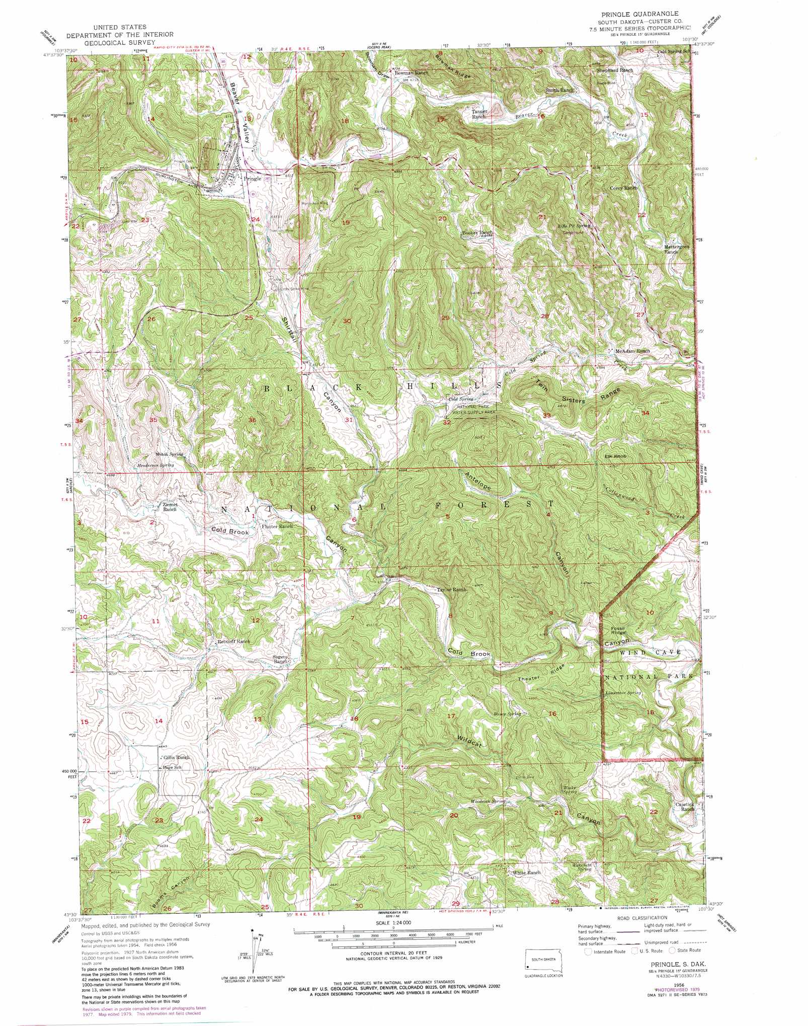
USGS Topo Quad 43103e5 - 1:24,000 scale
| Topo Map Name: | Pringle |
| USGS Topo Quad ID: | 43103e5 |
| Print Size: | ca. 21 1/4" wide x 27" high |
| Southeast Coordinates: | 43.5° N latitude / 103.5° W longitude |
| Map Center Coordinates: | 43.5625° N latitude / 103.5625° W longitude |
| U.S. State: | SD |
| Filename: | o43103e5.jpg |
| Download Map JPG Image: | Pringle topo map 1:24,000 scale |
| Map Type: | Topographic |
| Topo Series: | 7.5´ |
| Map Scale: | 1:24,000 |
| Source of Map Images: | United States Geological Survey (USGS) |
| Alternate Map Versions: |
Pringle SD 1956, updated 1958 Download PDF Buy paper map Pringle SD 1956, updated 1973 Download PDF Buy paper map Pringle SD 1956, updated 1979 Download PDF Buy paper map Pringle SD 1956, updated 1979 Download PDF Buy paper map Pringle SD 1956, updated 1979 Download PDF Buy paper map Pringle SD 2012 Download PDF Buy paper map Pringle SD 2015 Download PDF Buy paper map |
| FStopo: | US Forest Service topo Pringle is available: Download FStopo PDF Download FStopo TIF |
1:24,000 Topo Quads surrounding Pringle
Signal Hill |
Berne |
Custer |
Iron Mountain |
Hayward |
Jewel Cave |
Fourmile |
Cicero Peak |
Mount Coolidge |
Butcher Hill |
Jewel Cave Se |
Argyle |
Pringle |
Wind Cave |
Boland Ridge |
Edgemont Ne |
Minnekahta |
Minnekahta Ne |
Hot Springs |
Buffalo Gap |
Edgemont |
Flint Hill |
Cascade Springs |
Angostura Reservoir |
Hot Springs Se |
> Back to 43103e1 at 1:100,000 scale
> Back to 43102a1 at 1:250,000 scale
> Back to U.S. Topo Maps home
Pringle topo map: Gazetteer
Pringle: Mines
Lucky Strike Mine elevation 1460m 4790′Myrtle Ann Mine elevation 1509m 4950′
Reede Mine elevation 1436m 4711′
Townsite Mine elevation 1548m 5078′
Pringle: Populated Places
Cold Spring II (historical) elevation 1426m 4678′Pringle elevation 1488m 4881′
Pringle: Ranges
Twin Sisters Range elevation 1484m 4868′Pringle: Ridges
Theater Ridge elevation 1345m 4412′Pringle: Springs
Busey Spring elevation 1342m 4402′Cold Spring elevation 1385m 4543′
Henderson Spring elevation 1407m 4616′
Limestone Spring elevation 1285m 4215′
Rifle Pit Spring elevation 1394m 4573′
Wakefield Spring elevation 1286m 4219′
Weeks Spring elevation 1274m 4179′
Witch Spring elevation 1403m 4603′
Woodcock Spring elevation 1294m 4245′
Pringle: Summits
Elk Knob elevation 1447m 4747′Fossil Ridge elevation 1348m 4422′
Pringle: Valleys
Antelope Canyon elevation 1303m 4274′Beaver Valley elevation 1482m 4862′
Bowman Draw elevation 1438m 4717′
Shirttail Canyon elevation 1338m 4389′
Pringle digital topo map on disk
Buy this Pringle topo map showing relief, roads, GPS coordinates and other geographical features, as a high-resolution digital map file on DVD:
Eastern Wyoming & Western South Dakota
Buy digital topo maps: Eastern Wyoming & Western South Dakota