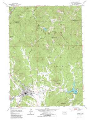
Custer Topo Map South Dakota
To zoom in, hover over the map of Custer
USGS Topo Quad 43103g5 - 1:24,000 scale
| Topo Map Name: | Custer |
| USGS Topo Quad ID: | 43103g5 |
| Print Size: | ca. 21 1/4" wide x 27" high |
| Southeast Coordinates: | 43.75° N latitude / 103.5° W longitude |
| Map Center Coordinates: | 43.8125° N latitude / 103.5625° W longitude |
| U.S. State: | SD |
| Filename: | o43103g5.jpg |
| Download Map JPG Image: | Custer topo map 1:24,000 scale |
| Map Type: | Topographic |
| Topo Series: | 7.5´ |
| Map Scale: | 1:24,000 |
| Source of Map Images: | United States Geological Survey (USGS) |
| Alternate Map Versions: |
Custer SD 1954, updated 1955 Download PDF Buy paper map Custer SD 1954, updated 1966 Download PDF Buy paper map Custer SD 1954, updated 1983 Download PDF Buy paper map Custer SD 1954, updated 1988 Download PDF Buy paper map Custer SD 1954, updated 1988 Download PDF Buy paper map Custer SD 2012 Download PDF Buy paper map Custer SD 2016 Download PDF Buy paper map |
| FStopo: | US Forest Service topo Custer is available: Download FStopo PDF Download FStopo TIF |
1:24,000 Topo Quads surrounding Custer
> Back to 43103e1 at 1:100,000 scale
> Back to 43102a1 at 1:250,000 scale
> Back to U.S. Topo Maps home
Custer topo map: Gazetteer
Custer: Arches
Needle Eye elevation 1933m 6341′Custer: Dams
Bismark Lake Dam elevation 1585m 5200′Stockade Lake Dam elevation 1576m 5170′
Sylvan Lake Dam elevation 1878m 6161′
Custer: Mines
A M Lode Mine elevation 1682m 5518′Aladdin Mine elevation 1670m 5479′
Arcade Numbers 1 and 2 Lodes Mine elevation 1601m 5252′
Bet Lode Mine elevation 1667m 5469′
Big Horn Lode Mine elevation 1693m 5554′
Clara Belle Mine elevation 1737m 5698′
Climax Mica Mine elevation 1637m 5370′
Come Along Lode Mine elevation 1634m 5360′
Custer Mica Lodes Numbers 1 and 2 Mine elevation 1646m 5400′
Custer Mountain Lode Mine elevation 1657m 5436′
Dalmon Mica Mine elevation 1661m 5449′
E M Lode Mine elevation 1703m 5587′
Earl Lode Mine elevation 1632m 5354′
First Find Mine elevation 1670m 5479′
Gap Lode Mine elevation 1889m 6197′
Gira and Ainsleys Dike Mine elevation 1968m 6456′
Homestead Number 2 Prospect Mine elevation 1649m 5410′
Homestead Number 3 Prospect Mine elevation 1671m 5482′
IXL Fraction Mine elevation 1608m 5275′
IXL Lode Mine elevation 1599m 5246′
IXL Lode Number 3 Mine elevation 1650m 5413′
IXL Number 4 Lode Mine elevation 1598m 5242′
Knowles Lode Claim Mine elevation 1706m 5597′
Lake Mine elevation 1951m 6400′
Lost Bonanza Mine elevation 1811m 5941′
Mica Queen Number 1 Prospect Mine elevation 1636m 5367′
Mitchell Number 2 Lode Mine elevation 1683m 5521′
Mohawk Mica Prospect Mine elevation 1580m 5183′
New Deal Lode Mine elevation 1676m 5498′
Noble Mica Mine elevation 1823m 5980′
November Mine elevation 1827m 5994′
OK Lode Mine elevation 1659m 5442′
OK Number 2 Lode Mine elevation 1683m 5521′
OK Number 4 Lode Mine elevation 1660m 5446′
Old Mike Mine elevation 1818m 5964′
Oreville Spar Mine elevation 1725m 5659′
Phelps Lode Mine elevation 1830m 6003′
Pick Lode Mine elevation 1682m 5518′
Poppy Lode Mine elevation 1795m 5889′
Saint Elmo Mine elevation 1780m 5839′
Shamrock Number 1 Lode Mine elevation 1635m 5364′
Sky Lode Mine elevation 1899m 6230′
Sunshine Mica Prospect Mine elevation 1692m 5551′
Surprise Mica Mine elevation 1671m 5482′
Sylvanite Lode Mine elevation 1641m 5383′
Terry and Terry Number 1 Claims Mine elevation 1605m 5265′
Tillisons Mine elevation 1610m 5282′
Tin King Mine elevation 1669m 5475′
Tin Queen Mine elevation 1727m 5666′
Tungsten Lode Mine elevation 1821m 5974′
Victory Mine elevation 1647m 5403′
Victory Number 1 Prospect Mine elevation 1621m 5318′
Walsh Mica Prospect Mine elevation 1655m 5429′
Wild Rose Mine elevation 1646m 5400′
Custer: Parks
Custer State Park - Norbeck Wildlife Preserve elevation 1616m 5301′Upper Pine Creek Natural Area elevation 1801m 5908′
Custer: Pillars
Cathedral Spires elevation 2065m 6774′Little Devils Tower elevation 2111m 6925′
The Needles elevation 1836m 6023′
Custer: Populated Places
Clara Belle Camp (historical) elevation 1744m 5721′Custer elevation 1620m 5314′
Oreville elevation 1635m 5364′
Sylvan Lake Resort elevation 1874m 6148′
Custer: Post Offices
Crazy Horse Post Office elevation 1889m 6197′Sylvan Lake Post Office (historical) elevation 1874m 6148′
Custer: Reservoirs
Bismark Lake elevation 1585m 5200′Stockade Lake elevation 1576m 5170′
Stockdale Lake elevation 1576m 5170′
Sylvan Lake elevation 1882m 6174′
Custer: Streams
Bismark Creek elevation 1588m 5209′Tenderfoot Creek elevation 1634m 5360′
White Horse Creek elevation 1630m 5347′
Willow Creek elevation 1585m 5200′
Custer: Summits
Buckhorn Mountain elevation 1922m 6305′Calamity Peak elevation 1701m 5580′
Custer Mountain elevation 1850m 6069′
Harney Peak elevation 2192m 7191′
Saint Elmo Peak elevation 1954m 6410′
Thunderhead Mountain elevation 1991m 6532′
Custer: Trails
Cathedral Spires Trail elevation 2002m 6568′Lost Cabin Trail elevation 1874m 6148′
Paha Sapa Trail elevation 1846m 6056′
Sunday Gulch Trail elevation 1867m 6125′
Sylvan Lake Harney Trail elevation 2076m 6811′
Custer: Tunnels
Hood Tunnel elevation 1882m 6174′Custer: Valleys
Bear Gulch elevation 1618m 5308′Johnson Canyon elevation 1674m 5492′
White Horse Gulch elevation 1631m 5351′
Custer digital topo map on disk
Buy this Custer topo map showing relief, roads, GPS coordinates and other geographical features, as a high-resolution digital map file on DVD:
Eastern Wyoming & Western South Dakota
Buy digital topo maps: Eastern Wyoming & Western South Dakota


