Newcastle Topo Map Wyoming
To zoom in, hover over the map of Newcastle
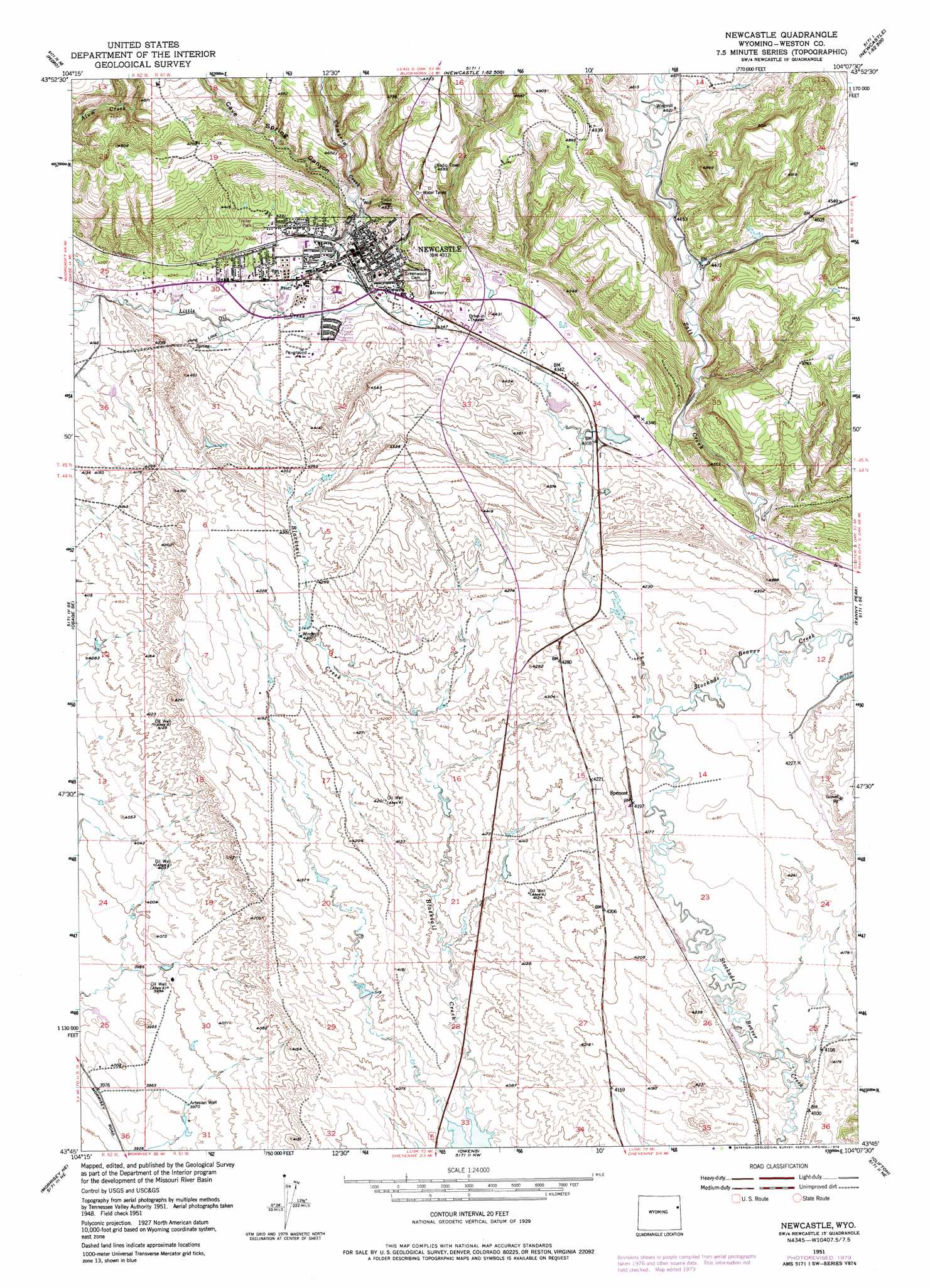
USGS Topo Quad 43104g2 - 1:24,000 scale
| Topo Map Name: | Newcastle |
| USGS Topo Quad ID: | 43104g2 |
| Print Size: | ca. 21 1/4" wide x 27" high |
| Southeast Coordinates: | 43.75° N latitude / 104.125° W longitude |
| Map Center Coordinates: | 43.8125° N latitude / 104.1875° W longitude |
| U.S. State: | WY |
| Filename: | o43104g2.jpg |
| Download Map JPG Image: | Newcastle topo map 1:24,000 scale |
| Map Type: | Topographic |
| Topo Series: | 7.5´ |
| Map Scale: | 1:24,000 |
| Source of Map Images: | United States Geological Survey (USGS) |
| Alternate Map Versions: |
Newcastle WY 1951, updated 1953 Download PDF Buy paper map Newcastle WY 1951, updated 1975 Download PDF Buy paper map Newcastle WY 1951, updated 1979 Download PDF Buy paper map Newcastle WY 2012 Download PDF Buy paper map Newcastle WY 2015 Download PDF Buy paper map |
1:24,000 Topo Quads surrounding Newcastle
Clay Spur |
Skull Creek |
Four Corners |
Parmlee Canyon |
Crows Nest Peak |
Osage |
Pedro |
Cambria |
Moon |
Preacher Spring |
Klodt Reservoir |
Osage Se |
Newcastle |
Fanny Peak |
Dead Horse Flats |
Timber Creek |
Morrisey Ne |
Owens |
Clifton |
Jewel Cave Nw |
Morrisey |
Morrisey Se |
Dewey Sw |
Dewey |
Jewel Cave Sw |
> Back to 43104e1 at 1:100,000 scale
> Back to 43104a1 at 1:250,000 scale
> Back to U.S. Topo Maps home
Newcastle topo map: Gazetteer
Newcastle: Dams
Spencer Number 2 Dam elevation 1281m 4202′Newcastle: Populated Places
Hill View Heights elevation 1324m 4343′Newcastle elevation 1319m 4327′
Newcastle: Post Offices
Newcastle Post Office elevation 1330m 4363′Newcastle: Reservoirs
Spencer Number 2 Reservoir elevation 1281m 4202′Newcastle: Streams
Cambria Creek elevation 1287m 4222′Cemetery Creek elevation 1343m 4406′
Coal Mine Creek elevation 1312m 4304′
Left Fork Blacktail Creek elevation 1228m 4028′
Salt Creek elevation 1291m 4235′
Newcastle: Valleys
Buck Pasture Draw elevation 1372m 4501′Cave Spring Canyon elevation 1320m 4330′
Dairy Draw elevation 1277m 4189′
Dey Draw elevation 1360m 4461′
Hilton Draw elevation 1349m 4425′
Johnson Draw elevation 1339m 4393′
Morris Draw elevation 1292m 4238′
Shank Draw elevation 1244m 4081′
Spencer Draw elevation 1251m 4104′
Newcastle digital topo map on disk
Buy this Newcastle topo map showing relief, roads, GPS coordinates and other geographical features, as a high-resolution digital map file on DVD:
Eastern Wyoming & Western South Dakota
Buy digital topo maps: Eastern Wyoming & Western South Dakota