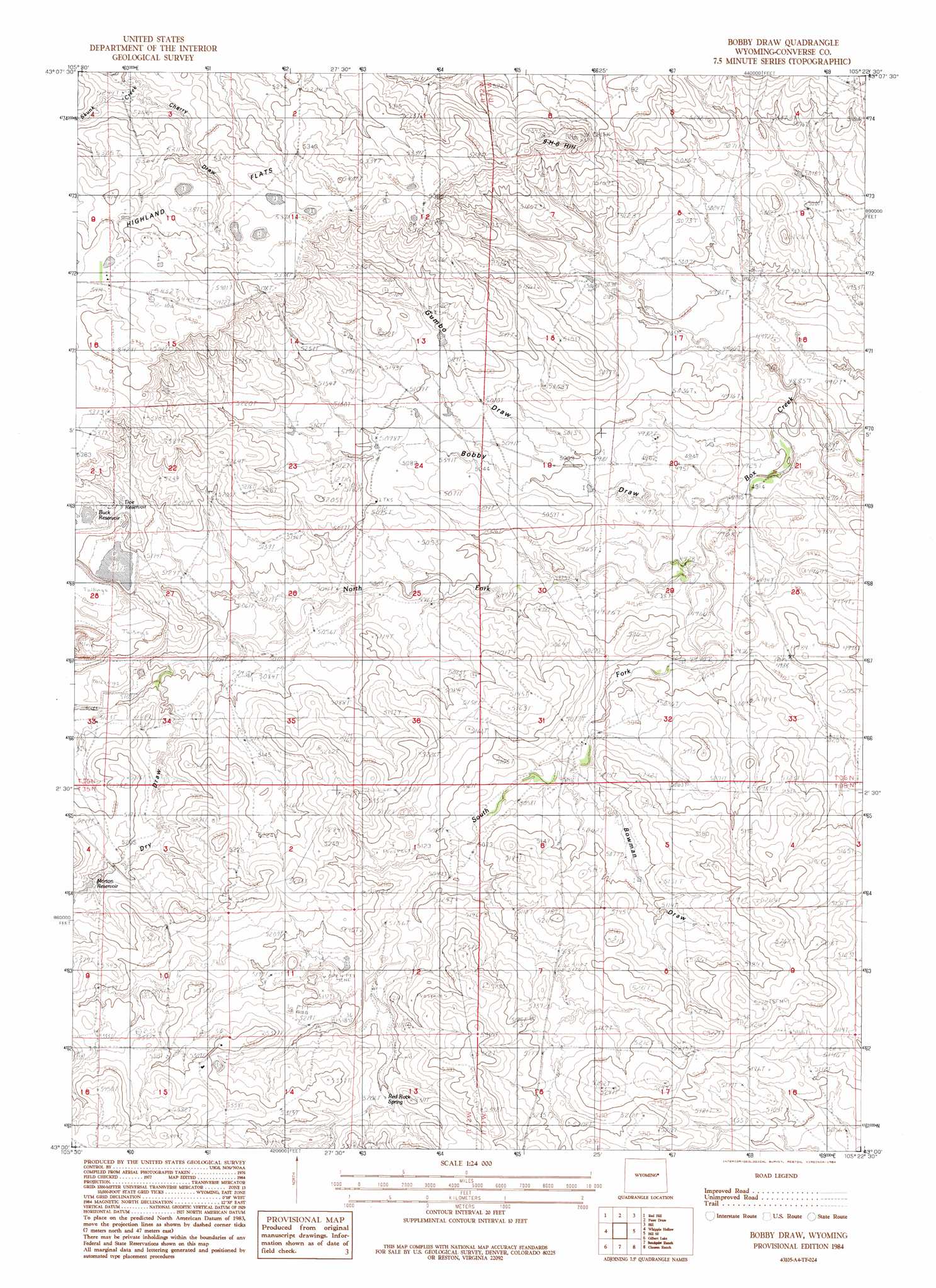
Bobby Draw Topo Map Wyoming
To zoom in, hover over the map of Bobby Draw
USGS Topo Quad 43105a4 - 1:24,000 scale
| Topo Map Name: | Bobby Draw |
| USGS Topo Quad ID: | 43105a4 |
| Print Size: | ca. 21 1/4" wide x 27" high |
| Southeast Coordinates: | 43° N latitude / 105.375° W longitude |
| Map Center Coordinates: | 43.0625° N latitude / 105.4375° W longitude |
| U.S. State: | WY |
| Filename: | o43105a4.jpg |
| Download Map JPG Image: | Bobby Draw topo map 1:24,000 scale |
| Map Type: | Topographic |
| Topo Series: | 7.5´ |
| Map Scale: | 1:24,000 |
| Source of Map Images: | United States Geological Survey (USGS) |
| Alternate Map Versions: |
Bobby Draw WY 1984, updated 1984 Download PDF Buy paper map Bobby Draw WY 2012 Download PDF Buy paper map Bobby Draw WY 2015 Download PDF Buy paper map |
1:24,000 Topo Quads surrounding Bobby Draw
Bear Creek |
Coal Draw South |
Alta Creek |
Dugout Creek South |
Tin Can Lake |
Suicide Hill |
Red Hill |
Patsy Draw |
Bill |
Bill 4 Nw |
Holdup Hollow |
Whipple Hollow |
Bobby Draw |
Bill Se |
Bill 4 Sw |
Leuenberger Ranch |
Gilbert Lake |
Sundquist Ranch |
Clausen Ranch |
Simpson Draw Nw |
Careyhurst |
Orpha |
Douglas |
Antelope Creek |
Simpson Draw |
> Back to 43105a1 at 1:100,000 scale
> Back to 43104a1 at 1:250,000 scale
> Back to U.S. Topo Maps home
Bobby Draw topo map: Gazetteer
Bobby Draw: Dams
Antone Dike elevation 1576m 5170′Doe Dam elevation 1590m 5216′
Enlargement Tailings Basin Evaporation Reservoir Dam elevation 1569m 5147′
Lightning Dike elevation 1562m 5124′
Bobby Draw: Reservoirs
Doe Reservoir elevation 1590m 5216′Enlargement Tailings Basin Evaporation Reservoir elevation 1569m 5147′
Morton Reservoir elevation 1586m 5203′
Bobby Draw: Springs
Red Rock Spring elevation 1590m 5216′Bobby Draw: Streams
North Fork Box Creek elevation 1500m 4921′South Fork Box Creek elevation 1501m 4924′
Bobby Draw: Summits
Nine-H-6 Hill elevation 1627m 5337′Bobby Draw: Valleys
Bobby Draw elevation 1500m 4921′Bowman Draw elevation 1531m 5022′
Cherry Draw elevation 1591m 5219′
Dry Draw elevation 1549m 5082′
Gumbo Draw elevation 1521m 4990′
Bobby Draw digital topo map on disk
Buy this Bobby Draw topo map showing relief, roads, GPS coordinates and other geographical features, as a high-resolution digital map file on DVD:
Eastern Wyoming & Western South Dakota
Buy digital topo maps: Eastern Wyoming & Western South Dakota