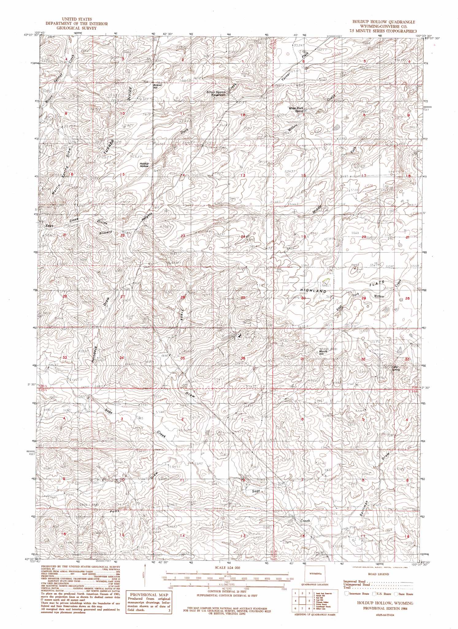
Holdup Hollow Topo Map Wyoming
To zoom in, hover over the map of Holdup Hollow
USGS Topo Quad 43105a6 - 1:24,000 scale
| Topo Map Name: | Holdup Hollow |
| USGS Topo Quad ID: | 43105a6 |
| Print Size: | ca. 21 1/4" wide x 27" high |
| Southeast Coordinates: | 43° N latitude / 105.625° W longitude |
| Map Center Coordinates: | 43.0625° N latitude / 105.6875° W longitude |
| U.S. State: | WY |
| Filename: | o43105a6.jpg |
| Download Map JPG Image: | Holdup Hollow topo map 1:24,000 scale |
| Map Type: | Topographic |
| Topo Series: | 7.5´ |
| Map Scale: | 1:24,000 |
| Source of Map Images: | United States Geological Survey (USGS) |
| Alternate Map Versions: |
Holdup Hollow WY 1984, updated 1984 Download PDF Buy paper map Holdup Hollow WY 2012 Download PDF Buy paper map Holdup Hollow WY 2015 Download PDF Buy paper map |
1:24,000 Topo Quads surrounding Holdup Hollow
Marsh Draw |
Thompson Draw |
Bear Creek |
Coal Draw South |
Alta Creek |
Fly Draw |
South Fork Reservoir |
Suicide Hill |
Red Hill |
Patsy Draw |
Gumbo Hill |
Coal Hill |
Holdup Hollow |
Whipple Hollow |
Bobby Draw |
Glenrock Nw |
Hylton Ranch |
Leuenberger Ranch |
Gilbert Lake |
Sundquist Ranch |
Parkerton |
Glenrock |
Careyhurst |
Orpha |
Douglas |
> Back to 43105a1 at 1:100,000 scale
> Back to 43104a1 at 1:250,000 scale
> Back to U.S. Topo Maps home
Holdup Hollow topo map: Gazetteer
Holdup Hollow: Flats
Turner Flats elevation 1682m 5518′Holdup Hollow: Mines
Bill Smith Mine elevation 1688m 5538′Holdup Hollow: Populated Places
Birkner Hill elevation 1731m 5679′Holdup Hollow: Reservoirs
Silver Spoon Reservoir elevation 1686m 5531′Holdup Hollow: Ridges
Turner Divide elevation 1701m 5580′Holdup Hollow: Springs
Lake Spring elevation 1675m 5495′Martin Spring elevation 1757m 5764′
White Rock Spring elevation 1665m 5462′
Holdup Hollow: Summits
Blizzard Heights elevation 1771m 5810′Morris Hill elevation 1738m 5702′
Holdup Hollow: Valleys
Frank Draw elevation 1623m 5324′Hornbeck Draw elevation 1654m 5426′
Martin Spring Draw elevation 1675m 5495′
Potts Draw elevation 1626m 5334′
Spillman Draw elevation 1596m 5236′
Holdup Hollow digital topo map on disk
Buy this Holdup Hollow topo map showing relief, roads, GPS coordinates and other geographical features, as a high-resolution digital map file on DVD:
Eastern Wyoming & Western South Dakota
Buy digital topo maps: Eastern Wyoming & Western South Dakota