Fiddleback Ranch Topo Map Wyoming
To zoom in, hover over the map of Fiddleback Ranch
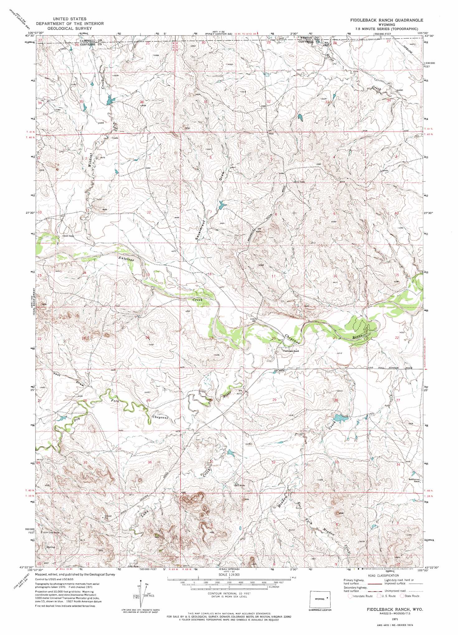
USGS Topo Quad 43105d1 - 1:24,000 scale
| Topo Map Name: | Fiddleback Ranch |
| USGS Topo Quad ID: | 43105d1 |
| Print Size: | ca. 21 1/4" wide x 27" high |
| Southeast Coordinates: | 43.375° N latitude / 105° W longitude |
| Map Center Coordinates: | 43.4375° N latitude / 105.0625° W longitude |
| U.S. State: | WY |
| Filename: | o43105d1.jpg |
| Download Map JPG Image: | Fiddleback Ranch topo map 1:24,000 scale |
| Map Type: | Topographic |
| Topo Series: | 7.5´ |
| Map Scale: | 1:24,000 |
| Source of Map Images: | United States Geological Survey (USGS) |
| Alternate Map Versions: |
Fiddleback Ranch WY 1971, updated 1974 Download PDF Buy paper map Fiddleback Ranch WY 2012 Download PDF Buy paper map Fiddleback Ranch WY 2015 Download PDF Buy paper map |
| FStopo: | US Forest Service topo Fiddleback Ranch is available: Download FStopo PDF Download FStopo TIF |
1:24,000 Topo Quads surrounding Fiddleback Ranch
Reno Reservoir |
Piney Canyon Nw |
Piney Canyon Ne |
Darlington Draw West |
Darlington Draw East |
Teckla |
Piney Canyon Sw |
Piney Canyon Se |
Lion Creek |
Poddy Creek |
Dugout Creek North |
Coal Bank Draw |
Fiddleback Ranch |
Wagonhound Creek |
Wagonhound Creek Ne |
Dugout Creek South |
Tin Can Lake |
Esau Spring |
Pinnacle Rocks |
Calf Draw |
Bill |
Bill 4 Nw |
Bill 4 Ne |
Split Hill |
Mercer Draw |
> Back to 43105a1 at 1:100,000 scale
> Back to 43104a1 at 1:250,000 scale
> Back to U.S. Topo Maps home
Fiddleback Ranch topo map: Gazetteer
Fiddleback Ranch: Dams
Sherwin 9-249-6 Dam elevation 1335m 4379′Fiddleback Ranch: Reservoirs
Sherwin 9-249-6 Reservoir elevation 1335m 4379′Fiddleback Ranch: Streams
Antelope Creek elevation 1317m 4320′Dry Fork Cheyenne River elevation 1317m 4320′
East Fork Meadow Creek elevation 1355m 4445′
Lake Creek elevation 1329m 4360′
Meadow Creek elevation 1314m 4311′
Wildcat Creek elevation 1329m 4360′
Fiddleback Ranch: Valleys
Sauerkraut Draw elevation 1321m 4333′Vest Draw elevation 1335m 4379′
Fiddleback Ranch digital topo map on disk
Buy this Fiddleback Ranch topo map showing relief, roads, GPS coordinates and other geographical features, as a high-resolution digital map file on DVD:
Eastern Wyoming & Western South Dakota
Buy digital topo maps: Eastern Wyoming & Western South Dakota