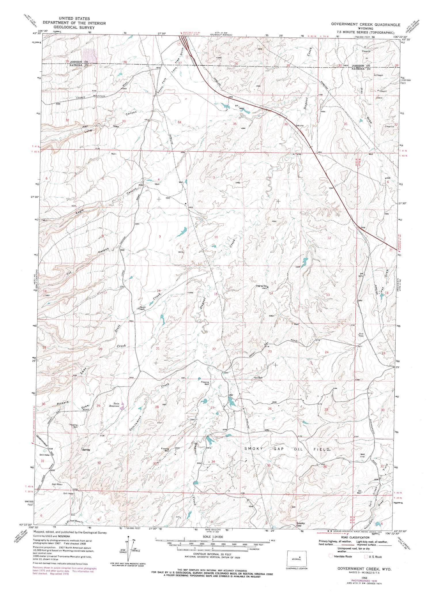
Government Creek Topo Map Wyoming
To zoom in, hover over the map of Government Creek
USGS Topo Quad 43106d4 - 1:24,000 scale
| Topo Map Name: | Government Creek |
| USGS Topo Quad ID: | 43106d4 |
| Print Size: | ca. 21 1/4" wide x 27" high |
| Southeast Coordinates: | 43.375° N latitude / 106.375° W longitude |
| Map Center Coordinates: | 43.4375° N latitude / 106.4375° W longitude |
| U.S. State: | WY |
| Filename: | o43106d4.jpg |
| Download Map JPG Image: | Government Creek topo map 1:24,000 scale |
| Map Type: | Topographic |
| Topo Series: | 7.5´ |
| Map Scale: | 1:24,000 |
| Source of Map Images: | United States Geological Survey (USGS) |
| Alternate Map Versions: |
Government Creek WY 1968, updated 1973 Download PDF Buy paper map Government Creek WY 1968, updated 1978 Download PDF Buy paper map Government Creek WY 2012 Download PDF Buy paper map Government Creek WY 2015 Download PDF Buy paper map |
1:24,000 Topo Quads surrounding Government Creek
Kaycee |
Kaycee Ne |
Figure 8 Reservoir |
Sussex |
House Creek |
T T T Ranch |
Wall Creek |
Dugout Ranch |
Dead Woman Crossing |
Linch |
Broken Horn Creek |
Salt Canyon |
Government Creek |
Midwest |
Edgerton |
Fiftymile Flat |
Camel Hump Reservoir |
Big Gulch |
Salt Creek |
Gillam Draw West |
Reynolds Reservoir |
Merino |
Statzer Point |
Teapot Rock |
Seven L Creek West |
> Back to 43106a1 at 1:100,000 scale
> Back to 43106a1 at 1:250,000 scale
> Back to U.S. Topo Maps home
Government Creek topo map: Gazetteer
Government Creek: Dams
Scott Dam elevation 1495m 4904′Government Creek: Gaps
Smoky Gap elevation 1629m 5344′Government Creek: Oilfields
Salt Creek Oil Field elevation 1554m 5098′Smoky Gap Oil Field elevation 1567m 5141′
Government Creek: Reservoirs
Scott Reservoir elevation 1495m 4904′Twin Reservoir elevation 1538m 5045′
Government Creek: Streams
Government Creek elevation 1498m 4914′Lane Creek elevation 1487m 4878′
Scott Creek elevation 1482m 4862′
Government Creek: Summits
Government Hill elevation 1688m 5538′Government Creek: Valleys
Eagle Canyon elevation 1491m 4891′Long Canyon elevation 1492m 4895′
Pickard Draw elevation 1573m 5160′
Toy Canyon elevation 1513m 4963′
Government Creek digital topo map on disk
Buy this Government Creek topo map showing relief, roads, GPS coordinates and other geographical features, as a high-resolution digital map file on DVD:
Eastern Wyoming & Western South Dakota
Buy digital topo maps: Eastern Wyoming & Western South Dakota