Dugout Ranch Topo Map Wyoming
To zoom in, hover over the map of Dugout Ranch
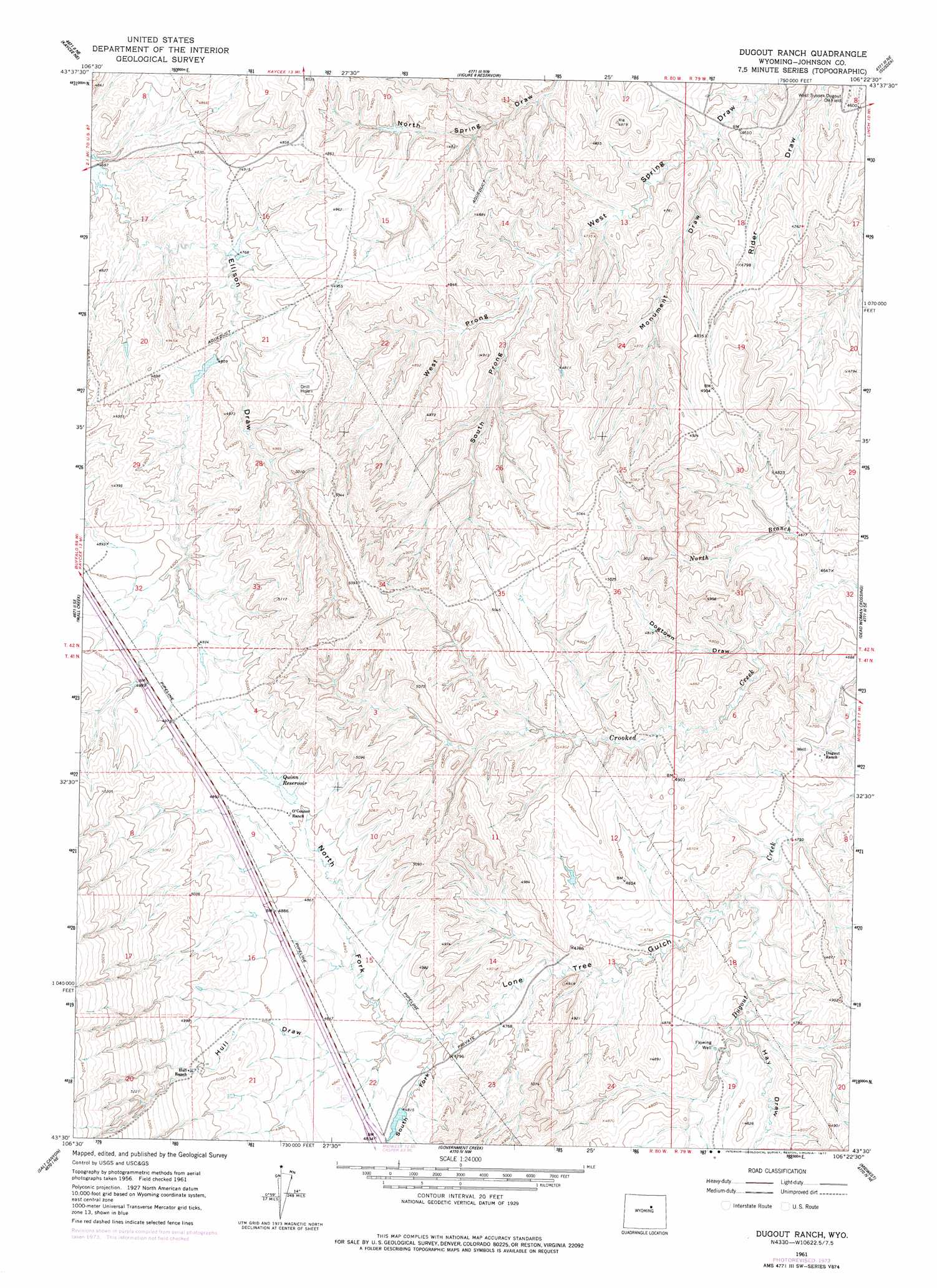
USGS Topo Quad 43106e4 - 1:24,000 scale
| Topo Map Name: | Dugout Ranch |
| USGS Topo Quad ID: | 43106e4 |
| Print Size: | ca. 21 1/4" wide x 27" high |
| Southeast Coordinates: | 43.5° N latitude / 106.375° W longitude |
| Map Center Coordinates: | 43.5625° N latitude / 106.4375° W longitude |
| U.S. State: | WY |
| Filename: | o43106e4.jpg |
| Download Map JPG Image: | Dugout Ranch topo map 1:24,000 scale |
| Map Type: | Topographic |
| Topo Series: | 7.5´ |
| Map Scale: | 1:24,000 |
| Source of Map Images: | United States Geological Survey (USGS) |
| Alternate Map Versions: |
Dugout Ranch WY 1961, updated 1965 Download PDF Buy paper map Dugout Ranch WY 1961, updated 1977 Download PDF Buy paper map Dugout Ranch WY 2012 Download PDF Buy paper map Dugout Ranch WY 2015 Download PDF Buy paper map |
1:24,000 Topo Quads surrounding Dugout Ranch
Hibbard Draw |
Dry Creek Reservoir |
Fourmile Reservoir |
Soldier Creek |
Fort Reno |
Kaycee |
Kaycee Ne |
Figure 8 Reservoir |
Sussex |
House Creek |
T T T Ranch |
Wall Creek |
Dugout Ranch |
Dead Woman Crossing |
Linch |
Broken Horn Creek |
Salt Canyon |
Government Creek |
Midwest |
Edgerton |
Fiftymile Flat |
Camel Hump Reservoir |
Big Gulch |
Salt Creek |
Gillam Draw West |
> Back to 43106e1 at 1:100,000 scale
> Back to 43106a1 at 1:250,000 scale
> Back to U.S. Topo Maps home
Dugout Ranch topo map: Gazetteer
Dugout Ranch: Dams
Quinn Dam elevation 1497m 4911′Dugout Ranch: Reservoirs
Quinn Reservoir elevation 1496m 4908′Dugout Ranch: Streams
North Branch Crooked Creek elevation 1411m 4629′Dugout Ranch: Valleys
Andrus Draw elevation 1433m 4701′Dogtown Draw elevation 1428m 4685′
Hay Draw elevation 1445m 4740′
Hull Draw elevation 1467m 4812′
Lone Tree Gulch elevation 1422m 4665′
Monument Draw elevation 1400m 4593′
North Fork Lone Tree Gulch elevation 1456m 4776′
South Fork Lone Tree Gulch elevation 1455m 4773′
South Prong West Spring Draw elevation 1442m 4730′
West Prong West Spring Draw elevation 1442m 4730′
Dugout Ranch digital topo map on disk
Buy this Dugout Ranch topo map showing relief, roads, GPS coordinates and other geographical features, as a high-resolution digital map file on DVD:
Eastern Wyoming & Western South Dakota
Buy digital topo maps: Eastern Wyoming & Western South Dakota