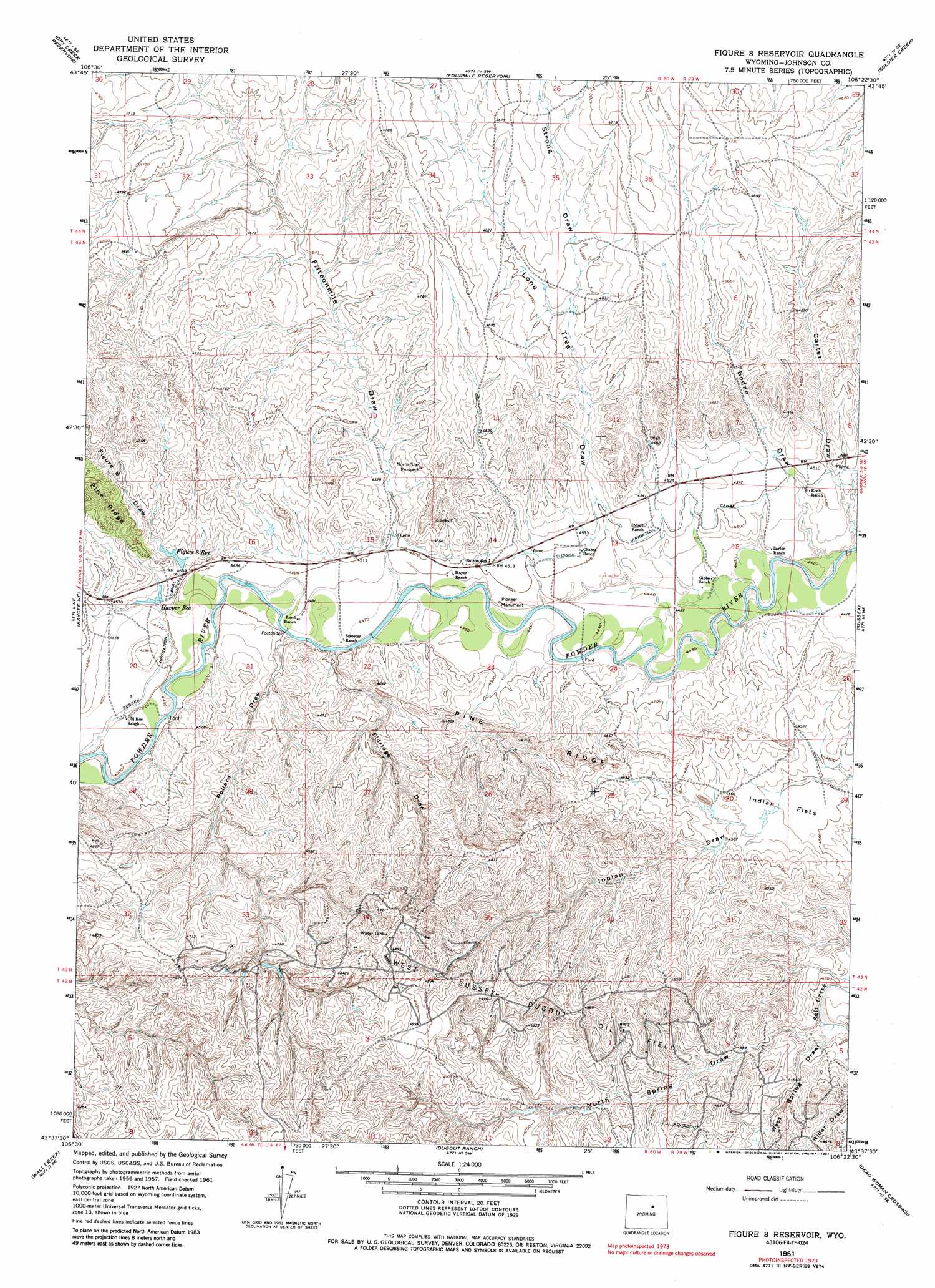
Figure 8 Reservoir Topo Map Wyoming
To zoom in, hover over the map of Figure 8 Reservoir
USGS Topo Quad 43106f4 - 1:24,000 scale
| Topo Map Name: | Figure 8 Reservoir |
| USGS Topo Quad ID: | 43106f4 |
| Print Size: | ca. 21 1/4" wide x 27" high |
| Southeast Coordinates: | 43.625° N latitude / 106.375° W longitude |
| Map Center Coordinates: | 43.6875° N latitude / 106.4375° W longitude |
| U.S. State: | WY |
| Filename: | o43106f4.jpg |
| Download Map JPG Image: | Figure 8 Reservoir topo map 1:24,000 scale |
| Map Type: | Topographic |
| Topo Series: | 7.5´ |
| Map Scale: | 1:24,000 |
| Source of Map Images: | United States Geological Survey (USGS) |
| Alternate Map Versions: |
Figure 8 Reservoir WY 1961, updated 1964 Download PDF Buy paper map Figure 8 Reservoir WY 1961, updated 1984 Download PDF Buy paper map Figure 8 Reservoir WY 2012 Download PDF Buy paper map Figure 8 Reservoir WY 2015 Download PDF Buy paper map |
1:24,000 Topo Quads surrounding Figure 8 Reservoir
Schlicht Draw |
Antelope Draw |
Elaine Draw |
Provence Ranch |
Hoe Ranch |
Hibbard Draw |
Dry Creek Reservoir |
Fourmile Reservoir |
Soldier Creek |
Fort Reno |
Kaycee |
Kaycee Ne |
Figure 8 Reservoir |
Sussex |
House Creek |
T T T Ranch |
Wall Creek |
Dugout Ranch |
Dead Woman Crossing |
Linch |
Broken Horn Creek |
Salt Canyon |
Government Creek |
Midwest |
Edgerton |
> Back to 43106e1 at 1:100,000 scale
> Back to 43106a1 at 1:250,000 scale
> Back to U.S. Topo Maps home
Figure 8 Reservoir topo map: Gazetteer
Figure 8 Reservoir: Canals
Sussex Irrigation Canal elevation 1383m 4537′Figure 8 Reservoir: Flats
Indian Flats elevation 1377m 4517′Figure 8 Reservoir: Mines
Desert Queen Mine elevation 1439m 4721′North Star Prospect elevation 1407m 4616′
Figure 8 Reservoir: Oilfields
West Sussex-Dugout Oil Field elevation 1468m 4816′Figure 8 Reservoir: Parks
Pioneer Monument elevation 1367m 4484′Figure 8 Reservoir: Reservoirs
Figure 8 Reservoir elevation 1382m 4534′Harper Reservoir elevation 1382m 4534′
Figure 8 Reservoir: Valleys
Bodan Draw elevation 1368m 4488′Carter Draw elevation 1367m 4484′
Eldridge Draw elevation 1361m 4465′
Fifteenmile Draw elevation 1368m 4488′
Figure 8 Draw elevation 1383m 4537′
Lone Tree Draw elevation 1354m 4442′
North Spring Draw elevation 1361m 4465′
Pollard Draw elevation 1363m 4471′
Strong Draw elevation 1396m 4580′
West Spring Draw elevation 1367m 4484′
Figure 8 Reservoir digital topo map on disk
Buy this Figure 8 Reservoir topo map showing relief, roads, GPS coordinates and other geographical features, as a high-resolution digital map file on DVD:
Eastern Wyoming & Western South Dakota
Buy digital topo maps: Eastern Wyoming & Western South Dakota