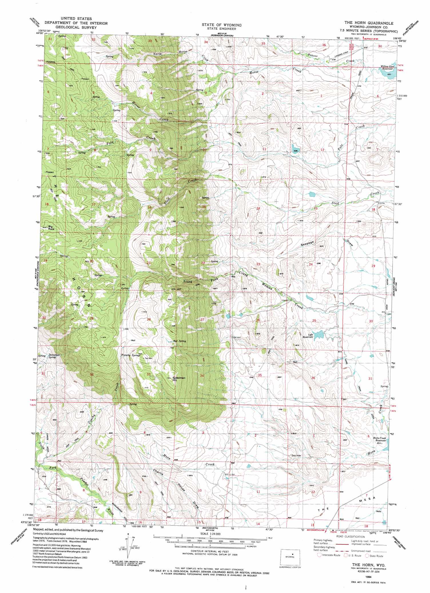
The Horn Topo Map Wyoming
To zoom in, hover over the map of The Horn
USGS Topo Quad 43106h7 - 1:24,000 scale
| Topo Map Name: | The Horn |
| USGS Topo Quad ID: | 43106h7 |
| Print Size: | ca. 21 1/4" wide x 27" high |
| Southeast Coordinates: | 43.875° N latitude / 106.75° W longitude |
| Map Center Coordinates: | 43.9375° N latitude / 106.8125° W longitude |
| U.S. State: | WY |
| Filename: | o43106h7.jpg |
| Download Map JPG Image: | The Horn topo map 1:24,000 scale |
| Map Type: | Topographic |
| Topo Series: | 7.5´ |
| Map Scale: | 1:24,000 |
| Source of Map Images: | United States Geological Survey (USGS) |
| Alternate Map Versions: |
The Horn WY 1984, updated 1984 Download PDF Buy paper map The Horn WY 2012 Download PDF Buy paper map The Horn WY 2015 Download PDF Buy paper map |
1:24,000 Topo Quads surrounding The Horn
Powder River Pass |
Caribou Creek |
Klondike Ranch |
T A Ranch |
Ta Ranch Ne |
Hazelton Peak |
Hazelton |
Robinson Canyon |
Purdy Reservoir |
Trabing |
Beartrap Meadows |
Packsaddle Canyon |
The Horn |
Schlicht Draw |
Antelope Draw |
Tabletop |
Fraker Mountain |
Mayoworth |
Hibbard Draw |
Dry Creek Reservoir |
Turk Springs |
Barnum |
Red Fork Powder River |
Kaycee |
Kaycee Ne |
> Back to 43106e1 at 1:100,000 scale
> Back to 43106a1 at 1:250,000 scale
> Back to U.S. Topo Maps home
The Horn topo map: Gazetteer
The Horn: Canals
Cerlew Ditch elevation 1565m 5134′Close Call Ditch elevation 1574m 5164′
Frances Ditch elevation 1668m 5472′
Harris and Spang Ditch elevation 1579m 5180′
Hesse Ditch elevation 1585m 5200′
Horn Creek Ditch elevation 1579m 5180′
Rambler Ditch elevation 1609m 5278′
Simmons Ditch elevation 1714m 5623′
The Horn: Dams
Dwight Dam elevation 1636m 5367′Dwite Dam elevation 1644m 5393′
Lyle Dam elevation 1593m 5226′
The Horn: Mines
South Fork Crazy Woman Mine elevation 1679m 5508′The Horn: Reservoirs
Dwight Reservoir elevation 1636m 5367′Dwite Reservoir elevation 1644m 5393′
Lyle Reservoir elevation 1585m 5200′
Lyle Reservoir elevation 1593m 5226′
The Horn: Ridges
The Horn elevation 2386m 7828′The Horn: Springs
Dancehall Spring elevation 1918m 6292′Frenchy Springs elevation 2338m 7670′
Red Spring elevation 2250m 7381′
The Horn: Streams
Coachy Creek elevation 1690m 5544′Horse Creek elevation 1571m 5154′
North Horse Creek elevation 1654m 5426′
The Horn: Summits
Specimen Hill elevation 2353m 7719′The Horn digital topo map on disk
Buy this The Horn topo map showing relief, roads, GPS coordinates and other geographical features, as a high-resolution digital map file on DVD:
Eastern Wyoming & Western South Dakota
Buy digital topo maps: Eastern Wyoming & Western South Dakota