Squaw Butte Ne Topo Map Wyoming
To zoom in, hover over the map of Squaw Butte Ne
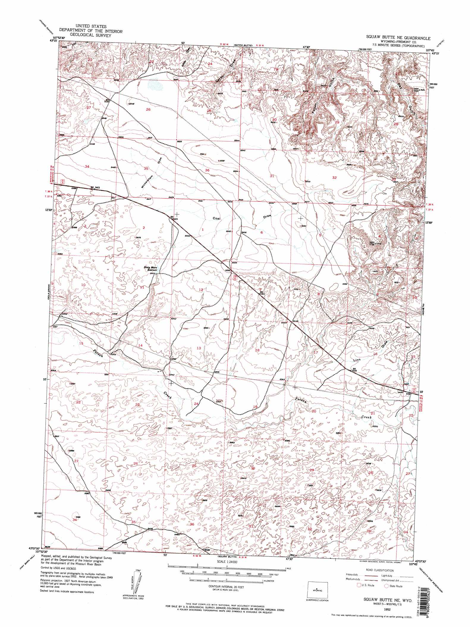
USGS Topo Quad 43107b7 - 1:24,000 scale
| Topo Map Name: | Squaw Butte Ne |
| USGS Topo Quad ID: | 43107b7 |
| Print Size: | ca. 21 1/4" wide x 27" high |
| Southeast Coordinates: | 43.125° N latitude / 107.75° W longitude |
| Map Center Coordinates: | 43.1875° N latitude / 107.8125° W longitude |
| U.S. State: | WY |
| Filename: | o43107b7.jpg |
| Download Map JPG Image: | Squaw Butte Ne topo map 1:24,000 scale |
| Map Type: | Topographic |
| Topo Series: | 7.5´ |
| Map Scale: | 1:24,000 |
| Source of Map Images: | United States Geological Survey (USGS) |
| Alternate Map Versions: |
Squaw Butte NE WY 1952 Download PDF Buy paper map Squaw Butte NE WY 1952, updated 1953 Download PDF Buy paper map Squaw Butte NE WY 1952, updated 1953 Download PDF Buy paper map Squaw Butte NE WY 2012 Download PDF Buy paper map Squaw Butte NE WY 2015 Download PDF Buy paper map |
1:24,000 Topo Quads surrounding Squaw Butte Ne
Birdseye Pass |
Guffy Peak |
De Pass |
Arapahoe Butte |
Cottonwood Pass |
Bonneville |
Picard Ranch |
Gates Butte |
Lysite |
Lysite Se |
Shoshoni |
Ocla Draw |
Squaw Butte Ne |
Moneta |
Madden |
Fuller Reservoir |
Haybarn Hill |
Squaw Butte |
Seventy One Reservoir |
Moneta Se |
Campbell Ridge |
Double Butte |
Butte Well |
Love Ranch |
Miles Ranch |
> Back to 43107a1 at 1:100,000 scale
> Back to 43106a1 at 1:250,000 scale
> Back to U.S. Topo Maps home
Squaw Butte Ne topo map: Gazetteer
Squaw Butte Ne: Reservoirs
Dinty Moore Reservoir elevation 1647m 5403′Squaw Butte Ne: Valleys
Coal Draw elevation 1655m 5429′Wickersham Draw elevation 1653m 5423′
Squaw Butte Ne digital topo map on disk
Buy this Squaw Butte Ne topo map showing relief, roads, GPS coordinates and other geographical features, as a high-resolution digital map file on DVD:
Eastern Wyoming & Western South Dakota
Buy digital topo maps: Eastern Wyoming & Western South Dakota