Badwater Se Topo Map Wyoming
To zoom in, hover over the map of Badwater Se
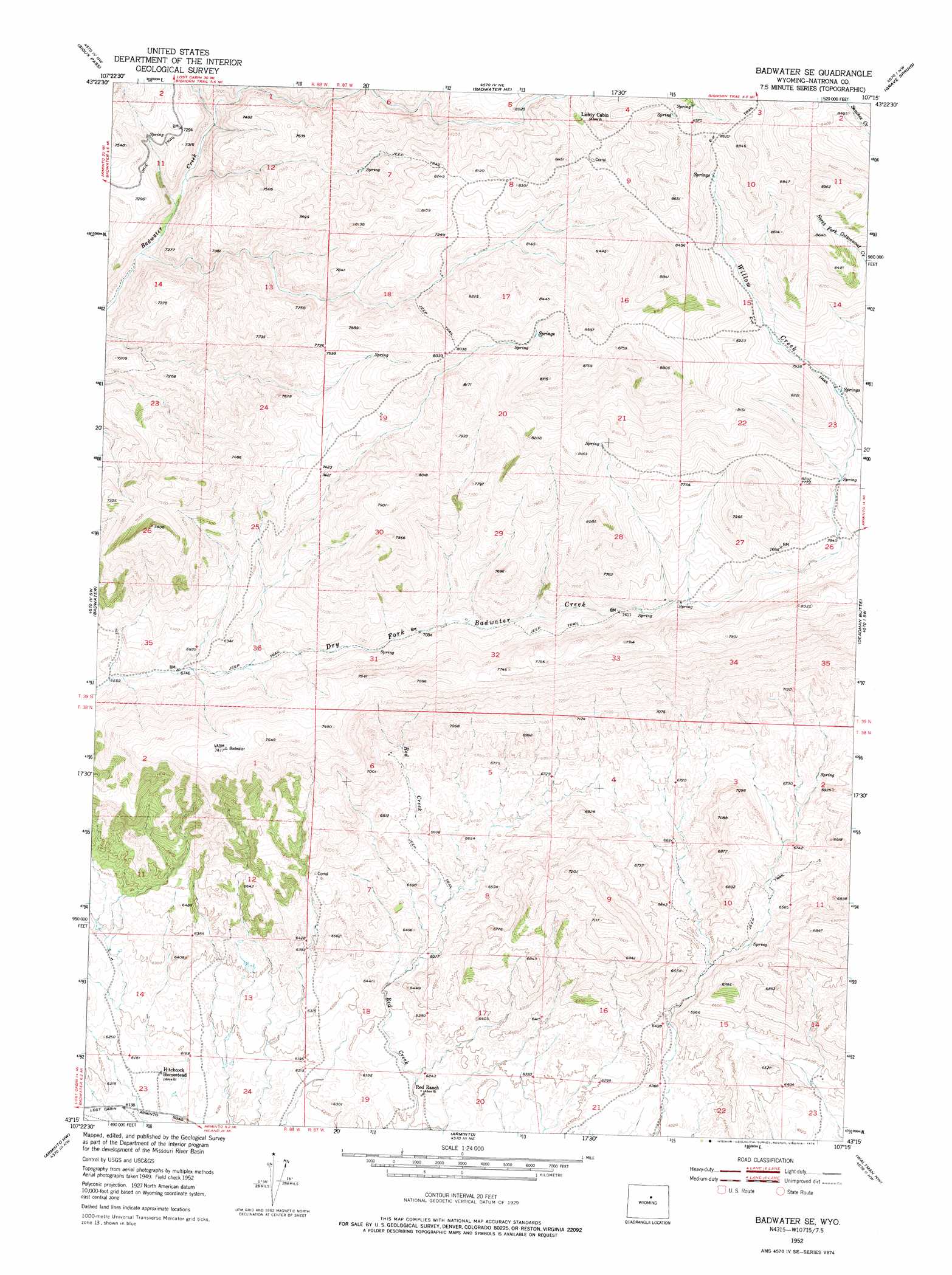
USGS Topo Quad 43107c3 - 1:24,000 scale
| Topo Map Name: | Badwater Se |
| USGS Topo Quad ID: | 43107c3 |
| Print Size: | ca. 21 1/4" wide x 27" high |
| Southeast Coordinates: | 43.25° N latitude / 107.25° W longitude |
| Map Center Coordinates: | 43.3125° N latitude / 107.3125° W longitude |
| U.S. State: | WY |
| Filename: | o43107c3.jpg |
| Download Map JPG Image: | Badwater Se topo map 1:24,000 scale |
| Map Type: | Topographic |
| Topo Series: | 7.5´ |
| Map Scale: | 1:24,000 |
| Source of Map Images: | United States Geological Survey (USGS) |
| Alternate Map Versions: |
Badwater SE WY 1952, updated 1954 Download PDF Buy paper map Badwater SE WY 1952, updated 1976 Download PDF Buy paper map Badwater SE WY 1952, updated 1976 Download PDF Buy paper map Badwater SE WY 2012 Download PDF Buy paper map Badwater SE WY 2015 Download PDF Buy paper map |
1:24,000 Topo Quads surrounding Badwater Se
Battle Mountain |
Cornell Gulch |
Lost Creek |
Cherry Creek Hill |
Gordon Creek |
Cottonwood Pass |
Sioux Pass |
Badwater Ne |
Grave Spring |
First Water Draw |
Lysite Se |
Badwater |
Badwater Se |
Deadman Butte |
Three Buttes |
Madden |
Arminto Nw |
Arminto |
Waltman Nw |
Notches Dome |
Moneta Se |
Arminto Sw |
Hiland |
Waltman |
Hells Half Acre |
> Back to 43107a1 at 1:100,000 scale
> Back to 43106a1 at 1:250,000 scale
> Back to U.S. Topo Maps home
Badwater Se topo map: Gazetteer
Badwater Se: Dams
Pine Ridge Dam elevation 1954m 6410′Red Bluff Dam elevation 1994m 6541′
Red Ranch Dam elevation 1919m 6295′
Three Forks Dam elevation 2003m 6571′
White Rock Dam elevation 1998m 6555′
Badwater Se: Mines
Allie Claims elevation 2269m 7444′Badwater Se: Reservoirs
Pine Ridge Reservoir elevation 1954m 6410′Red Bluff Reservoir elevation 1994m 6541′
Red Ranch Reservoir elevation 1919m 6295′
Three Forks Reservoir elevation 2003m 6571′
White Rock Reservoir elevation 1998m 6555′
Badwater Se: Streams
Willow Creek elevation 2355m 7726′Badwater Se: Trails
E-k Trail elevation 2641m 8664′Badwater Se digital topo map on disk
Buy this Badwater Se topo map showing relief, roads, GPS coordinates and other geographical features, as a high-resolution digital map file on DVD:
Eastern Wyoming & Western South Dakota
Buy digital topo maps: Eastern Wyoming & Western South Dakota