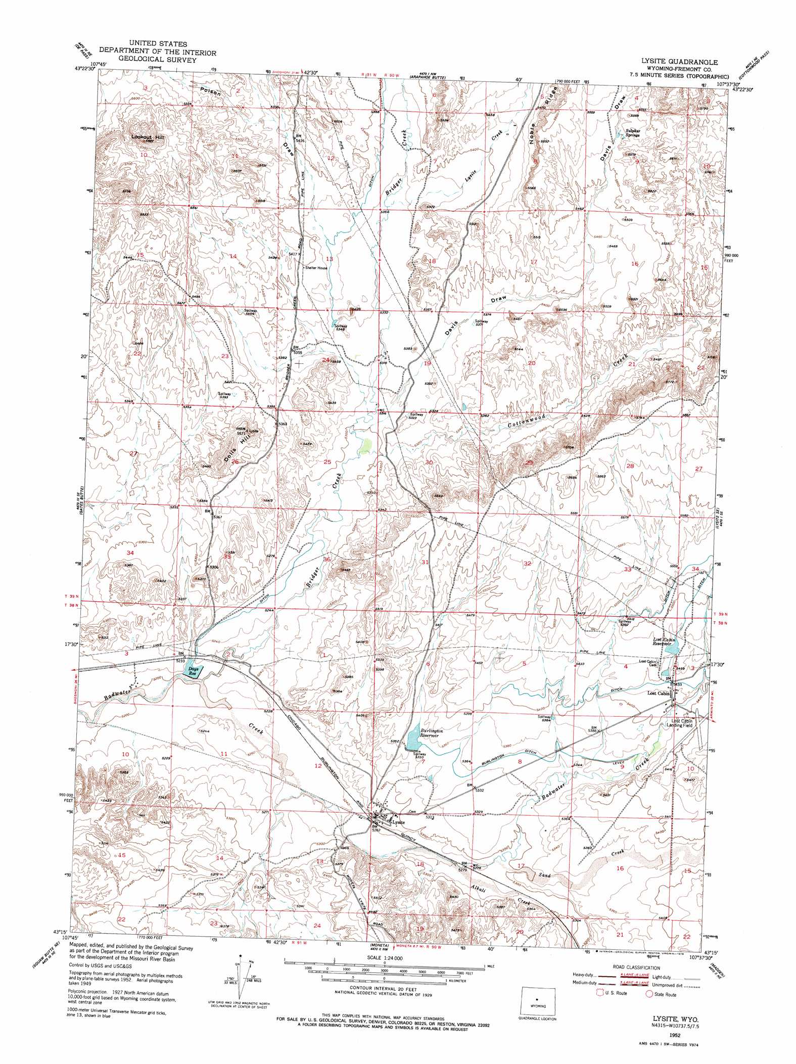
Lysite Topo Map Wyoming
To zoom in, hover over the map of Lysite
USGS Topo Quad 43107c6 - 1:24,000 scale
| Topo Map Name: | Lysite |
| USGS Topo Quad ID: | 43107c6 |
| Print Size: | ca. 21 1/4" wide x 27" high |
| Southeast Coordinates: | 43.25° N latitude / 107.625° W longitude |
| Map Center Coordinates: | 43.3125° N latitude / 107.6875° W longitude |
| U.S. State: | WY |
| Filename: | o43107c6.jpg |
| Download Map JPG Image: | Lysite topo map 1:24,000 scale |
| Map Type: | Topographic |
| Topo Series: | 7.5´ |
| Map Scale: | 1:24,000 |
| Source of Map Images: | United States Geological Survey (USGS) |
| Alternate Map Versions: |
Lysite WY 1952, updated 1953 Download PDF Buy paper map Lysite WY 1952, updated 1978 Download PDF Buy paper map Lysite WY 2012 Download PDF Buy paper map Lysite WY 2015 Download PDF Buy paper map |
1:24,000 Topo Quads surrounding Lysite
Blue Hill |
Rathbun Ranch |
Bull Mountain |
Battle Mountain |
Cornell Gulch |
Guffy Peak |
De Pass |
Arapahoe Butte |
Cottonwood Pass |
Sioux Pass |
Picard Ranch |
Gates Butte |
Lysite |
Lysite Se |
Badwater |
Ocla Draw |
Squaw Butte Ne |
Moneta |
Madden |
Arminto Nw |
Haybarn Hill |
Squaw Butte |
Seventy One Reservoir |
Moneta Se |
Arminto Sw |
> Back to 43107a1 at 1:100,000 scale
> Back to 43106a1 at 1:250,000 scale
> Back to U.S. Topo Maps home
Lysite topo map: Gazetteer
Lysite: Airports
Bridger Creek Airport elevation 1628m 5341′Lost Cabin Airport elevation 1647m 5403′
Lysite: Canals
Burlington Ditch elevation 1635m 5364′Lysite: Dams
Battle Axe Dam elevation 1586m 5203′Burlington Reservoir Dam elevation 1632m 5354′
Percy Dam elevation 1629m 5344′
Waterworks Number 3 Dam elevation 1668m 5472′
Lysite: Populated Places
Lost Cabin elevation 1649m 5410′Lysite elevation 1608m 5275′
Lysite: Reservoirs
Battle Axe Reservoir elevation 1586m 5203′Burlington Reservoir elevation 1630m 5347′
Days Reservoir elevation 1587m 5206′
Lost Cabin Reservoir elevation 1667m 5469′
OSW Reservoir elevation 1629m 5344′
Percy Reservoir elevation 1629m 5344′
Waterworks Number 3 Reservoir elevation 1668m 5472′
Lysite: Ridges
Noble Ridge elevation 1691m 5547′Lysite: Springs
Sulphur Springs elevation 1689m 5541′Lysite: Streams
Alkali Creek elevation 1605m 5265′Bridger Creek elevation 1586m 5203′
Cottonwood Creek elevation 1615m 5298′
Lysite Creek elevation 1633m 5357′
Sand Creek elevation 1614m 5295′
Lysite: Summits
Dolis Hill elevation 1673m 5488′Lookout Hill elevation 1773m 5816′
Lysite: Valleys
Davis Draw elevation 1616m 5301′Poison Draw elevation 1638m 5374′
Lysite digital topo map on disk
Buy this Lysite topo map showing relief, roads, GPS coordinates and other geographical features, as a high-resolution digital map file on DVD:
Eastern Wyoming & Western South Dakota
Buy digital topo maps: Eastern Wyoming & Western South Dakota