De Pass Topo Map Wyoming
To zoom in, hover over the map of De Pass
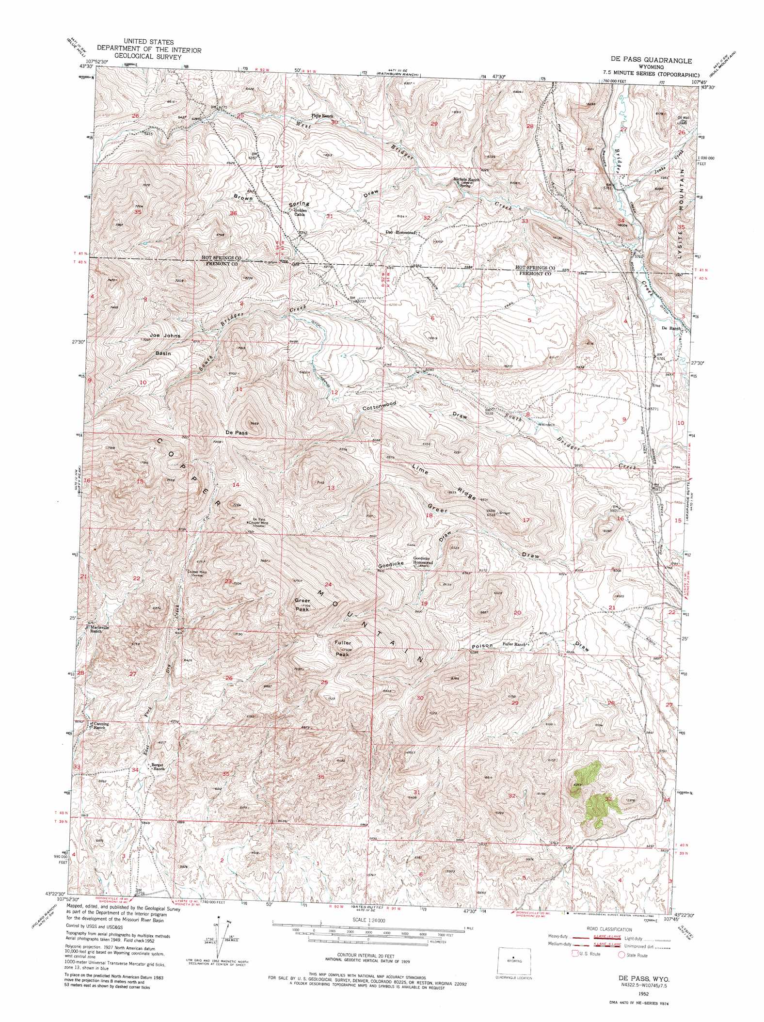
USGS Topo Quad 43107d7 - 1:24,000 scale
| Topo Map Name: | De Pass |
| USGS Topo Quad ID: | 43107d7 |
| Print Size: | ca. 21 1/4" wide x 27" high |
| Southeast Coordinates: | 43.375° N latitude / 107.75° W longitude |
| Map Center Coordinates: | 43.4375° N latitude / 107.8125° W longitude |
| U.S. State: | WY |
| Filename: | o43107d7.jpg |
| Download Map JPG Image: | De Pass topo map 1:24,000 scale |
| Map Type: | Topographic |
| Topo Series: | 7.5´ |
| Map Scale: | 1:24,000 |
| Source of Map Images: | United States Geological Survey (USGS) |
| Alternate Map Versions: |
De Pass WY 1952, updated 1953 Download PDF Buy paper map De Pass WY 1952, updated 1970 Download PDF Buy paper map De Pass WY 2012 Download PDF Buy paper map De Pass WY 2015 Download PDF Buy paper map |
1:24,000 Topo Quads surrounding De Pass
Red Hole |
Coyote Hill |
Packsaddle Creek |
Bader Draw |
Sand Point |
Devil Slide |
Blue Hill |
Rathbun Ranch |
Bull Mountain |
Battle Mountain |
Birdseye Pass |
Guffy Peak |
De Pass |
Arapahoe Butte |
Cottonwood Pass |
Bonneville |
Picard Ranch |
Gates Butte |
Lysite |
Lysite Se |
Shoshoni |
Ocla Draw |
Squaw Butte Ne |
Moneta |
Madden |
> Back to 43107a1 at 1:100,000 scale
> Back to 43106a1 at 1:250,000 scale
> Back to U.S. Topo Maps home
De Pass topo map: Gazetteer
De Pass: Basins
Joe Johns Basin elevation 2097m 6879′De Pass: Gaps
De Pass elevation 2124m 6968′De Pass: Mines
Blue Feather Mine elevation 1794m 5885′Bray-Kile Claim elevation 1764m 5787′
Cliff Number Four Mine elevation 2064m 6771′
Cliff Number One Mine elevation 1949m 6394′
DePass Mine elevation 2116m 6942′
East Fork Mine elevation 1914m 6279′
Fannie Number Four Mine elevation 1746m 5728′
Fuller Number Two Mine elevation 1790m 5872′
Hesitation Number One Mine elevation 1914m 6279′
Kermac Number One Mine elevation 1769m 5803′
McClain Mine elevation 1746m 5728′
Robeson Mine elevation 1995m 6545′
De Pass: Ridges
Lime Ridge elevation 1983m 6505′De Pass: Streams
Jenks Creek elevation 1761m 5777′West Bridger Creek elevation 1744m 5721′
De Pass: Summits
Fuller Peak elevation 2266m 7434′Greer Peak elevation 2328m 7637′
De Pass: Valleys
Brown Spring Draw elevation 1826m 5990′Cottonwood Draw elevation 1785m 5856′
Goedicke Draw elevation 1878m 6161′
De Pass digital topo map on disk
Buy this De Pass topo map showing relief, roads, GPS coordinates and other geographical features, as a high-resolution digital map file on DVD:
Eastern Wyoming & Western South Dakota
Buy digital topo maps: Eastern Wyoming & Western South Dakota