Guffy Peak Topo Map Wyoming
To zoom in, hover over the map of Guffy Peak
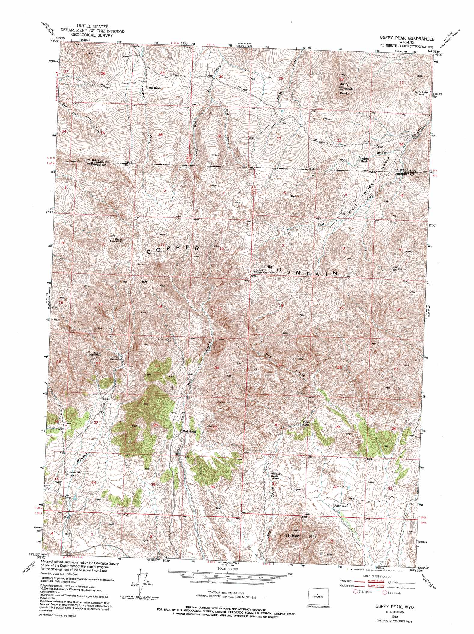
USGS Topo Quad 43107d8 - 1:24,000 scale
| Topo Map Name: | Guffy Peak |
| USGS Topo Quad ID: | 43107d8 |
| Print Size: | ca. 21 1/4" wide x 27" high |
| Southeast Coordinates: | 43.375° N latitude / 107.875° W longitude |
| Map Center Coordinates: | 43.4375° N latitude / 107.9375° W longitude |
| U.S. State: | WY |
| Filename: | o43107d8.jpg |
| Download Map JPG Image: | Guffy Peak topo map 1:24,000 scale |
| Map Type: | Topographic |
| Topo Series: | 7.5´ |
| Map Scale: | 1:24,000 |
| Source of Map Images: | United States Geological Survey (USGS) |
| Alternate Map Versions: |
Guffy Peak WY 1952, updated 1953 Download PDF Buy paper map Guffy Peak WY 1952, updated 1966 Download PDF Buy paper map Guffy Peak WY 1952, updated 1971 Download PDF Buy paper map Guffy Peak WY 1952, updated 1991 Download PDF Buy paper map Guffy Peak WY 2012 Download PDF Buy paper map Guffy Peak WY 2015 Download PDF Buy paper map |
1:24,000 Topo Quads surrounding Guffy Peak
Thermoplis |
Red Hole |
Coyote Hill |
Packsaddle Creek |
Bader Draw |
Wedding Of The Waters |
Devil Slide |
Blue Hill |
Rathbun Ranch |
Bull Mountain |
Boysen |
Birdseye Pass |
Guffy Peak |
De Pass |
Arapahoe Butte |
Bonneville Sw |
Bonneville |
Picard Ranch |
Gates Butte |
Lysite |
Hidden Valley |
Shoshoni |
Ocla Draw |
Squaw Butte Ne |
Moneta |
> Back to 43107a1 at 1:100,000 scale
> Back to 43106a1 at 1:250,000 scale
> Back to U.S. Topo Maps home
Guffy Peak topo map: Gazetteer
Guffy Peak: Basins
West Bridger Basin elevation 2100m 6889′Guffy Peak: Mines
Airline Number Two Mine elevation 1734m 5688′Bonanza Mine elevation 1732m 5682′
Comet Tungsten Mine elevation 2139m 7017′
Copper Glance Group Mine elevation 2328m 7637′
Copper Mountain Number One Mine elevation 2083m 6833′
Copper Mountain Number Two Mine elevation 2136m 7007′
Dawn Claim elevation 2171m 7122′
Discovery Number One Mine elevation 1851m 6072′
Hale Number One Mine elevation 2296m 7532′
Hoodoo Creek Claims elevation 2159m 7083′
McGraw Copper Mine elevation 2459m 8067′
Mint Number Two Mine elevation 1885m 6184′
Quien Sabe Mine elevation 2136m 7007′
Shortcut Number One Mine elevation 2134m 7001′
Stardust Tungsten Mine elevation 2214m 7263′
Whippet Number Eight Prospect elevation 2195m 7201′
Williams-Luman Mine elevation 2428m 7965′
Guffy Peak: Ranges
Bridger Mountains elevation 2167m 7109′Guffy Peak: Streams
East Fork Ditch Creek elevation 2179m 7148′East Fork West Bridger Creek elevation 2044m 6706′
West Fork elevation 2179m 7148′
West Fork Ditch Creek elevation 2179m 7148′
Guffy Peak: Summits
Copper Mountain elevation 2481m 8139′Guffy Peak elevation 2431m 7975′
Steffen Hill elevation 1914m 6279′
Guffy Peak digital topo map on disk
Buy this Guffy Peak topo map showing relief, roads, GPS coordinates and other geographical features, as a high-resolution digital map file on DVD:
Eastern Wyoming & Western South Dakota
Buy digital topo maps: Eastern Wyoming & Western South Dakota