Potato Butte Topo Map Wyoming
To zoom in, hover over the map of Potato Butte
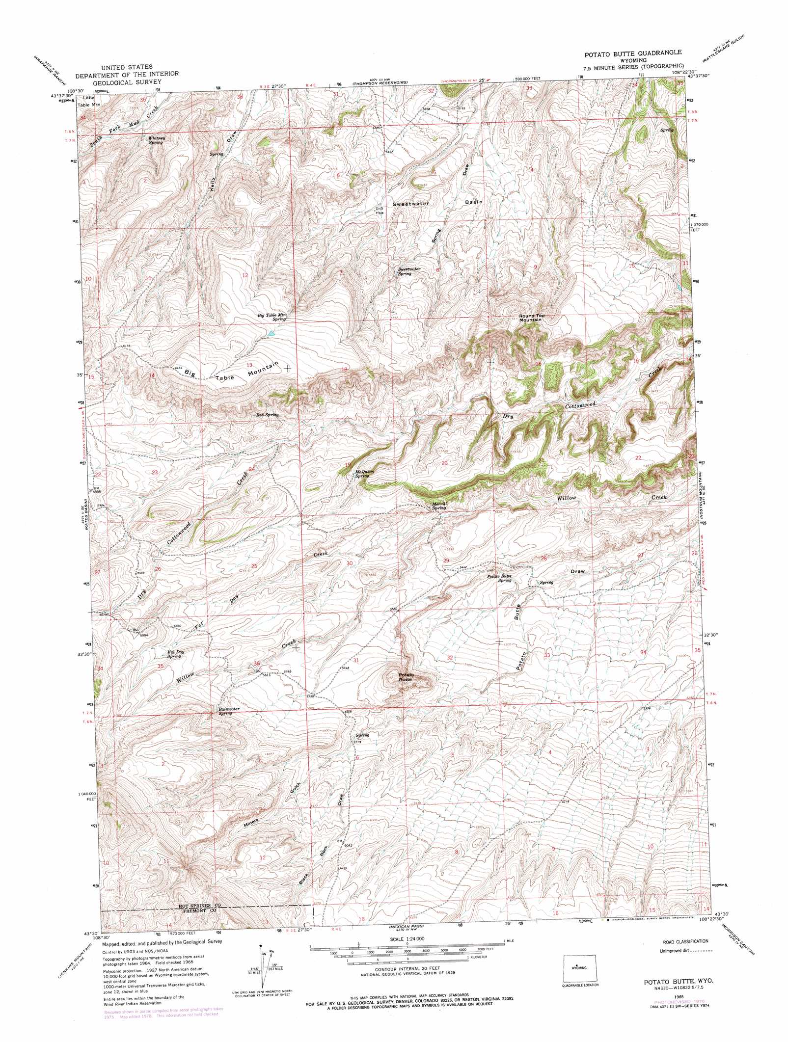
USGS Topo Quad 43108e4 - 1:24,000 scale
| Topo Map Name: | Potato Butte |
| USGS Topo Quad ID: | 43108e4 |
| Print Size: | ca. 21 1/4" wide x 27" high |
| Southeast Coordinates: | 43.5° N latitude / 108.375° W longitude |
| Map Center Coordinates: | 43.5625° N latitude / 108.4375° W longitude |
| U.S. State: | WY |
| Filename: | o43108e4.jpg |
| Download Map JPG Image: | Potato Butte topo map 1:24,000 scale |
| Map Type: | Topographic |
| Topo Series: | 7.5´ |
| Map Scale: | 1:24,000 |
| Source of Map Images: | United States Geological Survey (USGS) |
| Alternate Map Versions: |
Potato Butte WY 1965, updated 1968 Download PDF Buy paper map Potato Butte WY 1965, updated 1979 Download PDF Buy paper map Potato Butte WY 2012 Download PDF Buy paper map Potato Butte WY 2015 Download PDF Buy paper map |
1:24,000 Topo Quads surrounding Potato Butte
Crater Sink |
Hamilton Dome |
Gloin Reservoir |
Little Sand Draw |
Kirby |
Embar |
Arapahoe Ranch |
Thompson Reservoirs |
Rattlesnake Gulch |
Thermoplis |
Sheep Ridge |
Kates Basin |
Potato Butte |
Nostrum Mountain |
Wedding Of The Waters |
Shotgun Butte |
Jenkins Mountain |
Mexican Pass |
Morrison Canyon |
Boysen |
Pavillion Butte |
Harris Bridge |
Mexican Pass Sw |
Mexican Pass Se |
Bonneville Sw |
> Back to 43108e1 at 1:100,000 scale
> Back to 43108a1 at 1:250,000 scale
> Back to U.S. Topo Maps home
Potato Butte topo map: Gazetteer
Potato Butte: Basins
Sweetwater Basin elevation 1619m 5311′Potato Butte: Springs
Big Table Mountain Spring elevation 1859m 6099′McQueen Spring elevation 1691m 5547′
Merrill Spring elevation 1682m 5518′
Potato Butte Spring elevation 1589m 5213′
Rainwater Spring elevation 1823m 5980′
Red Spring elevation 1762m 5780′
Sweetwater Spring elevation 1686m 5531′
Val Day Spring elevation 1794m 5885′
Whitney Spring elevation 1658m 5439′
Potato Butte: Streams
Val Day Creek elevation 1677m 5501′Potato Butte: Summits
Big Table Mountain elevation 1976m 6482′Potato Butte elevation 1797m 5895′
Round Top Mountain elevation 1877m 6158′
Potato Butte: Valleys
Black Rock Draw elevation 1756m 5761′Miners Gulch elevation 1750m 5741′
Potato Butte digital topo map on disk
Buy this Potato Butte topo map showing relief, roads, GPS coordinates and other geographical features, as a high-resolution digital map file on DVD: