Bridger Lakes Topo Map Wyoming
To zoom in, hover over the map of Bridger Lakes
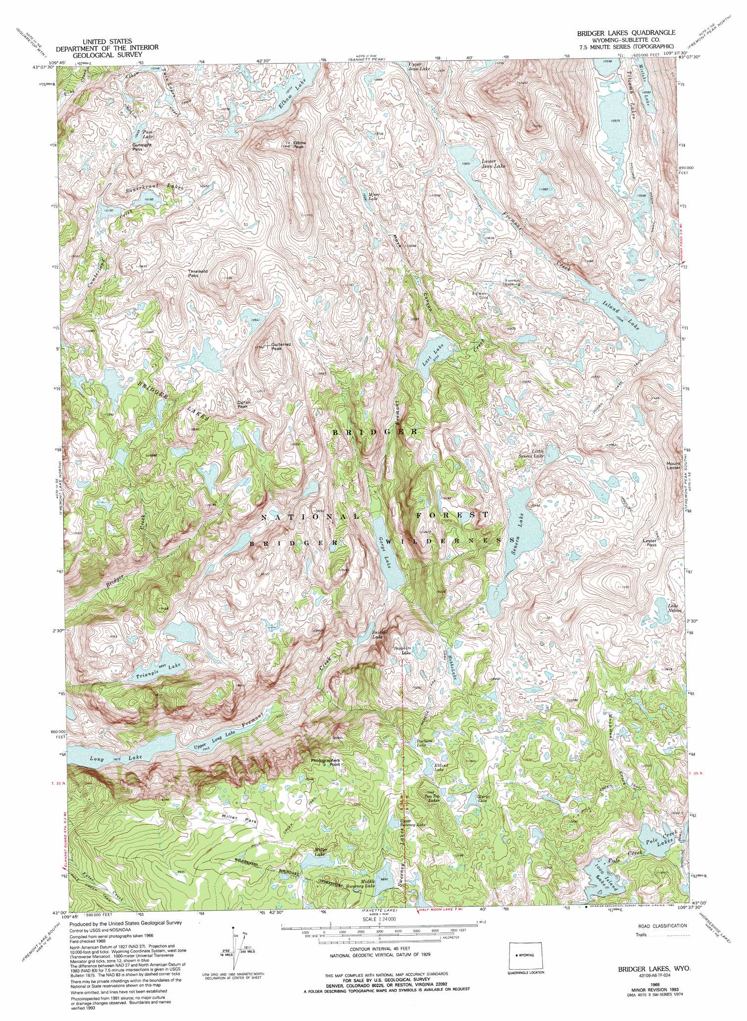
USGS Topo Quad 43109a6 - 1:24,000 scale
| Topo Map Name: | Bridger Lakes |
| USGS Topo Quad ID: | 43109a6 |
| Print Size: | ca. 21 1/4" wide x 27" high |
| Southeast Coordinates: | 43° N latitude / 109.625° W longitude |
| Map Center Coordinates: | 43.0625° N latitude / 109.6875° W longitude |
| U.S. State: | WY |
| Filename: | o43109a6.jpg |
| Download Map JPG Image: | Bridger Lakes topo map 1:24,000 scale |
| Map Type: | Topographic |
| Topo Series: | 7.5´ |
| Map Scale: | 1:24,000 |
| Source of Map Images: | United States Geological Survey (USGS) |
| Alternate Map Versions: |
Bridger Lakes WY 1968, updated 1973 Download PDF Buy paper map Bridger Lakes WY 1968, updated 1974 Download PDF Buy paper map Bridger Lakes WY 1968, updated 1985 Download PDF Buy paper map Bridger Lakes WY 1968, updated 1992 Download PDF Buy paper map Bridger Lakes WY 1968, updated 1993 Download PDF Buy paper map Bridger Lakes WY 1968, updated 1993 Download PDF Buy paper map Bridger Lakes WY 2012 Download PDF Buy paper map Bridger Lakes WY 2015 Download PDF Buy paper map |
| FStopo: | US Forest Service topo Bridger Lakes is available: Download FStopo PDF Download FStopo TIF |
1:24,000 Topo Quads surrounding Bridger Lakes
Big Sheep Mountain |
Green River Lakes |
Downs Mountain |
Ink Wells |
Hays Park |
Kendall Mountain |
Squaretop Mountain |
Gannett Peak |
Fremont Peak North |
Bob Lakes |
New Fork Lakes |
Fremont Lake North |
Bridger Lakes |
Fremont Peak South |
Alpine Lake |
Cora |
Fremont Lake South |
Fayette Lake |
Horseshoe Lake |
Halls Mountain |
Mount Airy |
Pinedale |
Boulder Lake |
Scab Creek |
Raid Lake |
> Back to 43109a1 at 1:100,000 scale
> Back to 43108a1 at 1:250,000 scale
> Back to U.S. Topo Maps home
Bridger Lakes topo map: Gazetteer
Bridger Lakes: Crossings
Fremont Crossing elevation 3121m 10239′Bridger Lakes: Flats
Miller Park elevation 3033m 9950′Bridger Lakes: Gaps
Gunsight Pass elevation 3207m 10521′Lester Pass elevation 3388m 11115′
Threlkeld Pass elevation 3311m 10862′
Bridger Lakes: Lakes
1000 Island Lake elevation 2925m 9596′Barbara Lake elevation 3115m 10219′
Bridger Lakes elevation 3081m 10108′
Eklund Lake elevation 3130m 10269′
Elbow Lake elevation 3286m 10780′
Gorge Lake elevation 2698m 8851′
Hobbs Lake elevation 3070m 10072′
Island Lake elevation 3155m 10351′
Lake Nelson elevation 3301m 10830′
Little Seneca Lake elevation 3154m 10347′
Lost Lake elevation 2975m 9760′
Lower Jean Lake elevation 3248m 10656′
Marys Lake elevation 3168m 10393′
Middle Sweeney Lake elevation 3018m 9901′
Miller Lake elevation 3004m 9855′
Miner Lake elevation 3196m 10485′
Mistake Lake elevation 3288m 10787′
Mistake Lake elevation 3288m 10787′
Pass Lake elevation 3188m 10459′
Pole Creek Lakes elevation 2962m 9717′
Sapphire Lake elevation 3120m 10236′
Sauerkraut Lakes elevation 3108m 10196′
Seneca Lake elevation 3131m 10272′
Suicide Lake elevation 2667m 8750′
Titcomb Lakes elevation 3225m 10580′
Triangle Lake elevation 2713m 8900′
Twin Lakes elevation 3159m 10364′
Two Top Lakes elevation 3182m 10439′
Upper Long Lake elevation 2423m 7949′
Upper Sweeney Lake elevation 3070m 10072′
Bridger Lakes: Streams
Elbow Creek elevation 2968m 9737′Monument Creek elevation 2964m 9724′
Bridger Lakes: Summits
Duran Peak elevation 3238m 10623′Elbow Peak elevation 3639m 11938′
Guiterrez Peak elevation 3456m 11338′
Photographers Point elevation 3076m 10091′
Bridger Lakes: Swamps
Big Water Slide elevation 3114m 10216′Bridger Lakes: Trails
Indian Pass Trail elevation 3219m 10561′Pole Creek Trail elevation 3100m 10170′
Seneca Lake Trail elevation 3083m 10114′
Titcomb Basin Trail elevation 3218m 10557′
Bridger Lakes: Valleys
Moya Canyon elevation 2976m 9763′Bridger Lakes digital topo map on disk
Buy this Bridger Lakes topo map showing relief, roads, GPS coordinates and other geographical features, as a high-resolution digital map file on DVD: