Snow Lake Topo Map Wyoming
To zoom in, hover over the map of Snow Lake
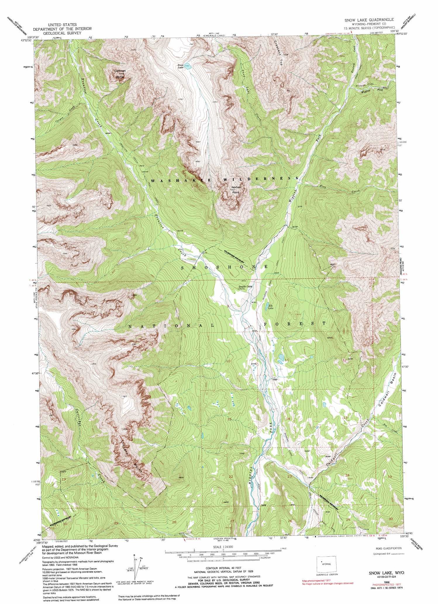
USGS Topo Quad 43109g5 - 1:24,000 scale
| Topo Map Name: | Snow Lake |
| USGS Topo Quad ID: | 43109g5 |
| Print Size: | ca. 21 1/4" wide x 27" high |
| Southeast Coordinates: | 43.75° N latitude / 109.5° W longitude |
| Map Center Coordinates: | 43.8125° N latitude / 109.5625° W longitude |
| U.S. State: | WY |
| Filename: | o43109g5.jpg |
| Download Map JPG Image: | Snow Lake topo map 1:24,000 scale |
| Map Type: | Topographic |
| Topo Series: | 7.5´ |
| Map Scale: | 1:24,000 |
| Source of Map Images: | United States Geological Survey (USGS) |
| Alternate Map Versions: |
Snow Lake WY 1956, updated 1958 Download PDF Buy paper map Snow Lake WY 1956, updated 1967 Download PDF Buy paper map Snow Lake WY 1956, updated 1992 Download PDF Buy paper map Snow Lake WY 1991, updated 1997 Download PDF Buy paper map Snow Lake WY 2012 Download PDF Buy paper map Snow Lake WY 2015 Download PDF Buy paper map |
| FStopo: | US Forest Service topo Snow Lake is available: Download FStopo PDF Download FStopo TIF |
1:24,000 Topo Quads surrounding Snow Lake
Yellow Mountain |
Fall Creek |
Needle Mountain |
Irish Rock |
Phelps Mountain |
Younts Peak |
Hardluck Mountain |
Emerald Lake |
Mount Burwell |
Francs Peak |
Shoshone Pass |
Five Pockets |
Snow Lake |
Wiggins Peak |
Dunrud Peak |
Esmond Park |
Ramshorn Peak |
Indian Point |
Castle Rock |
East Fork Basin |
Warm Spring Mountain |
Dubois |
Mason Draw |
Bain Draw |
Crow Mountain |
> Back to 43109e1 at 1:100,000 scale
> Back to 43108a1 at 1:250,000 scale
> Back to U.S. Topo Maps home
Snow Lake topo map: Gazetteer
Snow Lake: Basins
Caldwell Basin elevation 2524m 8280′Snow Lake: Cliffs
Lincoln Point elevation 3355m 11007′Norton Point elevation 3363m 11033′
Snow Lake: Lakes
Elk Lake elevation 2464m 8083′Snow Lake elevation 3428m 11246′
Snow Lake: Mines
Kirwin Mine elevation 2595m 8513′Snow Lake: Streams
Bug Creek elevation 2554m 8379′Caldwell Creek elevation 2399m 7870′
Canyon Creek elevation 2603m 8540′
Emerald Creek elevation 2571m 8435′
Fire Creek elevation 2520m 8267′
Frontier Creek elevation 2447m 8028′
Snow Lake Creek elevation 2521m 8270′
Snow Lake: Summits
Coffman Butte elevation 3282m 10767′Crescent Top elevation 3541m 11617′
Snow Lake: Trails
Frontier Creek Trail elevation 2628m 8622′Wiggins Fork Trail elevation 2484m 8149′
Snow Lake digital topo map on disk
Buy this Snow Lake topo map showing relief, roads, GPS coordinates and other geographical features, as a high-resolution digital map file on DVD: