Cache Creek Topo Map Wyoming
To zoom in, hover over the map of Cache Creek
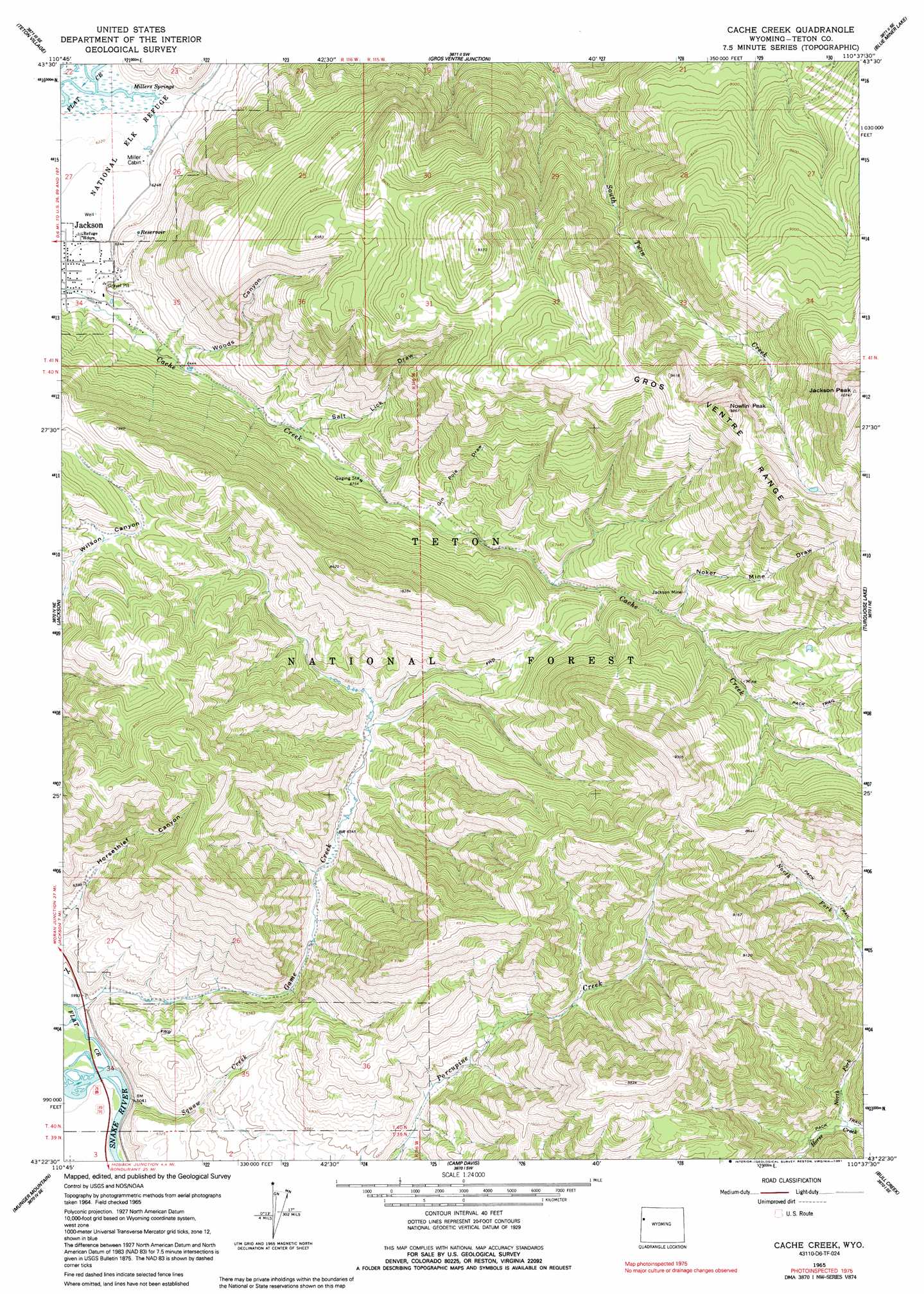
USGS Topo Quad 43110d6 - 1:24,000 scale
| Topo Map Name: | Cache Creek |
| USGS Topo Quad ID: | 43110d6 |
| Print Size: | ca. 21 1/4" wide x 27" high |
| Southeast Coordinates: | 43.375° N latitude / 110.625° W longitude |
| Map Center Coordinates: | 43.4375° N latitude / 110.6875° W longitude |
| U.S. State: | WY |
| Filename: | o43110d6.jpg |
| Download Map JPG Image: | Cache Creek topo map 1:24,000 scale |
| Map Type: | Topographic |
| Topo Series: | 7.5´ |
| Map Scale: | 1:24,000 |
| Source of Map Images: | United States Geological Survey (USGS) |
| Alternate Map Versions: |
Cache Creek WY 1965, updated 1968 Download PDF Buy paper map Cache Creek WY 1965, updated 1991 Download PDF Buy paper map Cache Creek WY 1996, updated 1998 Download PDF Buy paper map Cache Creek WY 2012 Download PDF Buy paper map Cache Creek WY 2015 Download PDF Buy paper map |
| FStopo: | US Forest Service topo Cache Creek is available: Download FStopo PDF Download FStopo TIF |
1:24,000 Topo Quads surrounding Cache Creek
Mount Bannon |
Grand Teton |
Moose |
Shadow Mountain |
Mount Leidy |
Rendezvous Peak |
Teton Village |
Gros Ventre Junction |
Blue Miner Lake |
Grizzly Lake |
Teton Pass |
Jackson |
Cache Creek |
Turquoise Lake |
Crystal Peak |
Observation Peak |
Munger Mountain |
Camp Davis |
Bull Creek |
Granite Falls |
Ferry Peak |
Pine Creek |
Bailey Lake |
Clause Peak |
Bondurant |
> Back to 43110a1 at 1:100,000 scale
> Back to 43110a1 at 1:250,000 scale
> Back to U.S. Topo Maps home
Cache Creek topo map: Gazetteer
Cache Creek: Mines
Jackson Mine elevation 2291m 7516′Sturlin and Sperl Mine elevation 2290m 7513′
Cache Creek: Springs
Millers Springs elevation 1897m 6223′Cache Creek: Streams
Flat Creek elevation 1815m 5954′Game Creek elevation 1815m 5954′
North Fork Horse Creek elevation 2033m 6669′
Nowlin Creek elevation 2045m 6709′
Squaw Creek elevation 1816m 5958′
Cache Creek: Summits
Jackson Peak elevation 3266m 10715′Nowlin Peak elevation 3008m 9868′
Cache Creek: Valleys
Gin Pole Draw elevation 2108m 6916′Noker Mine Draw elevation 2230m 7316′
Salt Lick Draw elevation 2037m 6683′
Woods Canyon elevation 1963m 6440′
Cache Creek digital topo map on disk
Buy this Cache Creek topo map showing relief, roads, GPS coordinates and other geographical features, as a high-resolution digital map file on DVD: