Angle Mountain Topo Map Wyoming
To zoom in, hover over the map of Angle Mountain
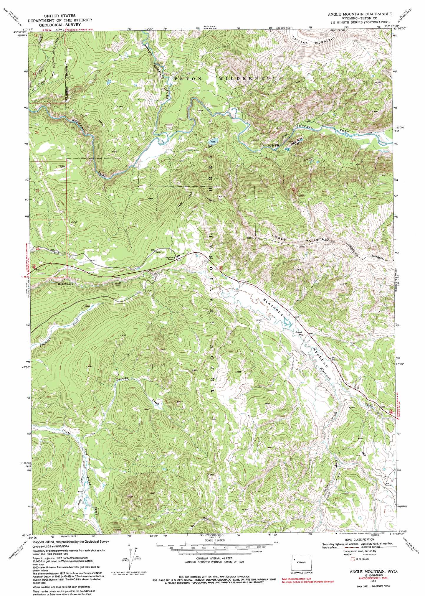
USGS Topo Quad 43110g2 - 1:24,000 scale
| Topo Map Name: | Angle Mountain |
| USGS Topo Quad ID: | 43110g2 |
| Print Size: | ca. 21 1/4" wide x 27" high |
| Southeast Coordinates: | 43.75° N latitude / 110.125° W longitude |
| Map Center Coordinates: | 43.8125° N latitude / 110.1875° W longitude |
| U.S. State: | WY |
| Filename: | o43110g2.jpg |
| Download Map JPG Image: | Angle Mountain topo map 1:24,000 scale |
| Map Type: | Topographic |
| Topo Series: | 7.5´ |
| Map Scale: | 1:24,000 |
| Source of Map Images: | United States Geological Survey (USGS) |
| Alternate Map Versions: |
Angle Mountain WY 1965, updated 1971 Download PDF Buy paper map Angle Mountain WY 1965, updated 1972 Download PDF Buy paper map Angle Mountain WY 1965, updated 1991 Download PDF Buy paper map Angle Mountain WY 1996, updated 1998 Download PDF Buy paper map Angle Mountain WY 2012 Download PDF Buy paper map Angle Mountain WY 2015 Download PDF Buy paper map |
| FStopo: | US Forest Service topo Angle Mountain is available: Download FStopo PDF Download FStopo TIF |
1:24,000 Topo Quads surrounding Angle Mountain
Bobcat Ridge |
Gravel Peak |
Two Ocean Pass |
Yellowstone Point |
Thorofare Plateau |
Whetstone Mountain |
Hunter Mountain |
Joy Peak |
Crater Lake |
Ferry Lake |
Davis Hill |
Rosies Ridge |
Angle Mountain |
Togwotee Pass |
Dundee Meadows |
Mount Leidy |
Green Mountain |
Tripod Peak |
Lava Mountain |
Kisinger Lakes |
Grizzly Lake |
Upper Slide Lake |
Burnt Mountain |
Sheridan Pass |
Fish Lake |
> Back to 43110e1 at 1:100,000 scale
> Back to 43110a1 at 1:250,000 scale
> Back to U.S. Topo Maps home
Angle Mountain topo map: Gazetteer
Angle Mountain: Flats
Blackrock Meadows elevation 2637m 8651′Angle Mountain: Gaps
Bear Cub Pass elevation 2314m 7591′Angle Mountain: Mines
Black Rock Meadows Mine elevation 2634m 8641′Angle Mountain: Streams
Bull Creek elevation 2619m 8592′Clear Creek elevation 2152m 7060′
Grizzly Creek elevation 2544m 8346′
North Buffalo Fork elevation 2162m 7093′
South Buffalo Fork elevation 2152m 7060′
Split Rock Creek elevation 2647m 8684′
Angle Mountain: Summits
Angle Mountain elevation 3197m 10488′Terrace Mountain elevation 3082m 10111′
Angle Mountain digital topo map on disk
Buy this Angle Mountain topo map showing relief, roads, GPS coordinates and other geographical features, as a high-resolution digital map file on DVD: