Etna Topo Map Idaho
To zoom in, hover over the map of Etna
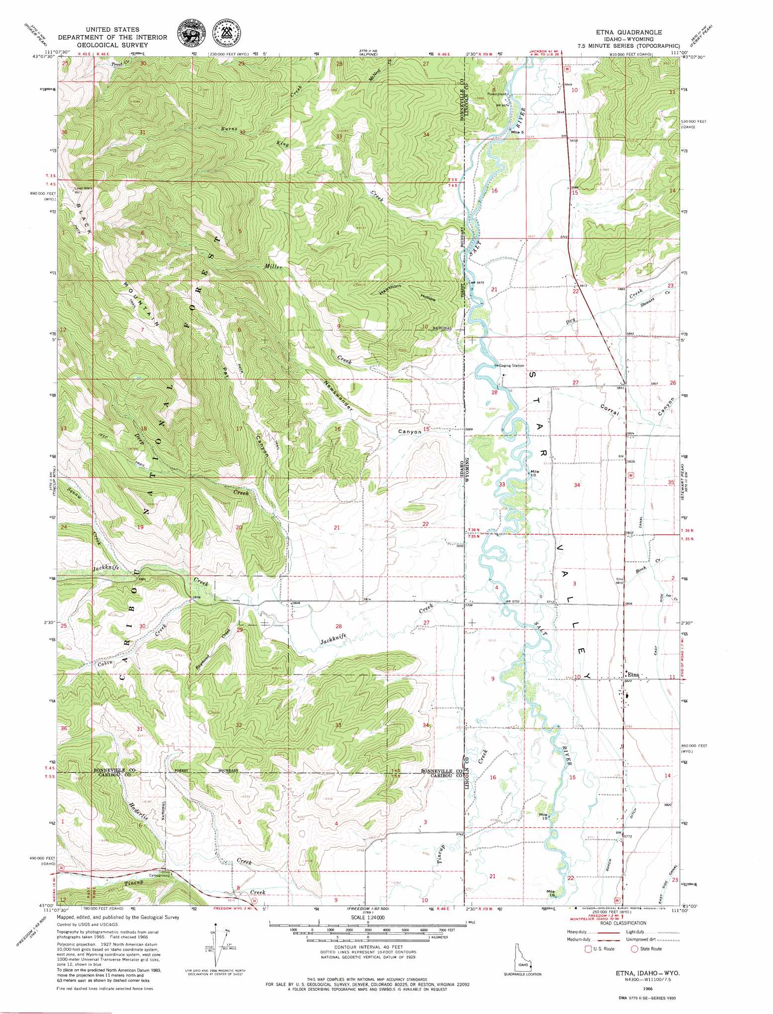
USGS Topo Quad 43111a1 - 1:24,000 scale
| Topo Map Name: | Etna |
| USGS Topo Quad ID: | 43111a1 |
| Print Size: | ca. 21 1/4" wide x 27" high |
| Southeast Coordinates: | 43° N latitude / 111° W longitude |
| Map Center Coordinates: | 43.0625° N latitude / 111.0625° W longitude |
| U.S. States: | ID, WY |
| Filename: | o43111a1.jpg |
| Download Map JPG Image: | Etna topo map 1:24,000 scale |
| Map Type: | Topographic |
| Topo Series: | 7.5´ |
| Map Scale: | 1:24,000 |
| Source of Map Images: | United States Geological Survey (USGS) |
| Alternate Map Versions: |
Etna WY 1966, updated 1969 Download PDF Buy paper map Etna WY 1966, updated 1979 Download PDF Buy paper map Etna WY 2011 Download PDF Buy paper map Etna WY 2015 Download PDF Buy paper map |
| FStopo: | US Forest Service topo Etna is available: Download FStopo PDF Download FStopo TIF |
1:24,000 Topo Quads surrounding Etna
Red Ridge |
Palisades Dam |
Mount Baird |
Observation Peak |
Munger Mountain |
Big Elk Mountain |
Poker Peak |
Alpine |
Ferry Peak |
Pine Creek |
Caribou Mountain |
Tincup Mountain |
Etna |
Stewart Peak |
Deer Creek |
Wayan East |
Stump Peak |
Thayne West |
Thayne East |
Man Peak |
Upper Valley |
Diamond Flat |
Auburn |
Grover |
Rock Lake Peak |
> Back to 43111a1 at 1:100,000 scale
> Back to 43110a1 at 1:250,000 scale
> Back to U.S. Topo Maps home
Etna topo map: Gazetteer
Etna: Canals
Baker Ditch elevation 1761m 5777′Etna: Populated Places
Etna elevation 1777m 5830′Etna: Streams
Birch Creek elevation 1774m 5820′Cabin Creek elevation 1786m 5859′
Deep Creek elevation 1760m 5774′
Dry Creek elevation 1733m 5685′
Grouse Creek elevation 1769m 5803′
Jackknife Creek elevation 1739m 5705′
Jackknife Creek elevation 1738m 5702′
King Creek elevation 1726m 5662′
King Creek elevation 1731m 5679′
Lee Creek elevation 1791m 5875′
Miller Creek elevation 1732m 5682′
Miller Creek elevation 1731m 5679′
Raymond Creek elevation 1775m 5823′
Squaw Creek elevation 1799m 5902′
Stewart Creek elevation 1793m 5882′
Tincup Creek elevation 1741m 5711′
Tincup Creek elevation 1741m 5711′
Etna: Valleys
Corral Canyon elevation 1735m 5692′Hawthorn Hollow elevation 1730m 5675′
Hawthorn Hollow elevation 1729m 5672′
Newswander Canyon elevation 1737m 5698′
Newswander Canyon elevation 1732m 5682′
Pat Canyon elevation 1838m 6030′
Star Valley elevation 1718m 5636′
Etna digital topo map on disk
Buy this Etna topo map showing relief, roads, GPS coordinates and other geographical features, as a high-resolution digital map file on DVD: