Bear Island Topo Map Idaho
To zoom in, hover over the map of Bear Island
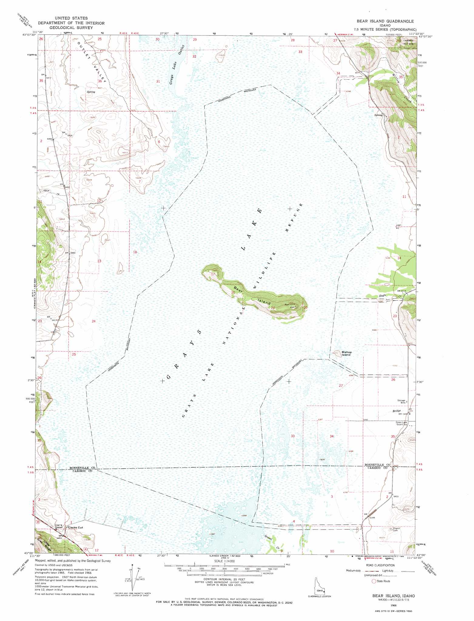
USGS Topo Quad 43111a4 - 1:24,000 scale
| Topo Map Name: | Bear Island |
| USGS Topo Quad ID: | 43111a4 |
| Print Size: | ca. 21 1/4" wide x 27" high |
| Southeast Coordinates: | 43° N latitude / 111.375° W longitude |
| Map Center Coordinates: | 43.0625° N latitude / 111.4375° W longitude |
| U.S. State: | ID |
| Filename: | o43111a4.jpg |
| Download Map JPG Image: | Bear Island topo map 1:24,000 scale |
| Map Type: | Topographic |
| Topo Series: | 7.5´ |
| Map Scale: | 1:24,000 |
| Source of Map Images: | United States Geological Survey (USGS) |
| Alternate Map Versions: |
Bear Island ID 1966, updated 1968 Download PDF Buy paper map Bear Island ID 2011 Download PDF Buy paper map Bear Island ID 2013 Download PDF Buy paper map |
| FStopo: | US Forest Service topo Bear Island is available: Download FStopo PDF Download FStopo TIF |
1:24,000 Topo Quads surrounding Bear Island
Jumpoff Hill |
Castle Rock |
Commissary Ridge |
Red Ridge |
Palisades Dam |
Long Valley |
Homer Valley |
Herman |
Big Elk Mountain |
Poker Peak |
Meadow Creek Mountain |
Little Valley Hills |
Bear Island |
Caribou Mountain |
Tincup Mountain |
Reservoir Mountain |
Henry |
Wayan West |
Wayan East |
Stump Peak |
The Dip |
China Hat |
Lower Valley |
Upper Valley |
Diamond Flat |
> Back to 43111a1 at 1:100,000 scale
> Back to 43110a1 at 1:250,000 scale
> Back to U.S. Topo Maps home
Bear Island topo map: Gazetteer
Bear Island: Dams
Grays Lake Dam elevation 1952m 6404′Bear Island: Gaps
Clarks Cut elevation 1951m 6400′Bear Island: Islands
Bear Island elevation 2028m 6653′Bishop Island elevation 1960m 6430′
Bear Island: Lakes
Grays Lake elevation 1949m 6394′Bear Island: Parks
Grays Lake National Wildlife Refuge elevation 1953m 6407′Bear Island: Populated Places
Gray elevation 1951m 6400′Bear Island: Reservoirs
Grays Lake elevation 1952m 6404′Bear Island: Streams
Bridge Creek elevation 1950m 6397′Eagle Creek elevation 1949m 6394′
Gravel Creek elevation 1948m 6391′
Jones Creek elevation 1949m 6394′
Little Valley Creek elevation 1949m 6394′
Willow Creek elevation 1949m 6394′
Bear Island digital topo map on disk
Buy this Bear Island topo map showing relief, roads, GPS coordinates and other geographical features, as a high-resolution digital map file on DVD: