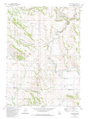
Dunn Basin Topo Map Idaho
To zoom in, hover over the map of Dunn Basin
USGS Topo Quad 43111a8 - 1:24,000 scale
| Topo Map Name: | Dunn Basin |
| USGS Topo Quad ID: | 43111a8 |
| Print Size: | ca. 21 1/4" wide x 27" high |
| Southeast Coordinates: | 43° N latitude / 111.875° W longitude |
| Map Center Coordinates: | 43.0625° N latitude / 111.9375° W longitude |
| U.S. State: | ID |
| Filename: | o43111a8.jpg |
| Download Map JPG Image: | Dunn Basin topo map 1:24,000 scale |
| Map Type: | Topographic |
| Topo Series: | 7.5´ |
| Map Scale: | 1:24,000 |
| Source of Map Images: | United States Geological Survey (USGS) |
| Alternate Map Versions: |
Dunn Basin ID 1981, updated 1981 Download PDF Buy paper map Dunn Basin ID 2010 Download PDF Buy paper map Dunn Basin ID 2013 Download PDF Buy paper map |
1:24,000 Topo Quads surrounding Dunn Basin
> Back to 43111a1 at 1:100,000 scale
> Back to 43110a1 at 1:250,000 scale
> Back to U.S. Topo Maps home
Dunn Basin topo map: Gazetteer
Dunn Basin: Basins
Dunn Basin elevation 1776m 5826′Dunn Basin: Bridges
Morgan Bridge elevation 1752m 5748′Dunn Basin: Populated Places
Morgan elevation 1753m 5751′Dunn Basin: Streams
Brush Creek elevation 1701m 5580′Deadman Creek elevation 1746m 5728′
Grave Creek elevation 1771m 5810′
Rawlins Creek elevation 1732m 5682′
Short Creek elevation 1823m 5980′
Sunday Creek elevation 1800m 5905′
Supon Creek elevation 1761m 5777′
Trail Creek elevation 1696m 5564′
Warbonnet Creek elevation 1813m 5948′
Dunn Basin digital topo map on disk
Buy this Dunn Basin topo map showing relief, roads, GPS coordinates and other geographical features, as a high-resolution digital map file on DVD:


