Poison Creek Topo Map Idaho
To zoom in, hover over the map of Poison Creek
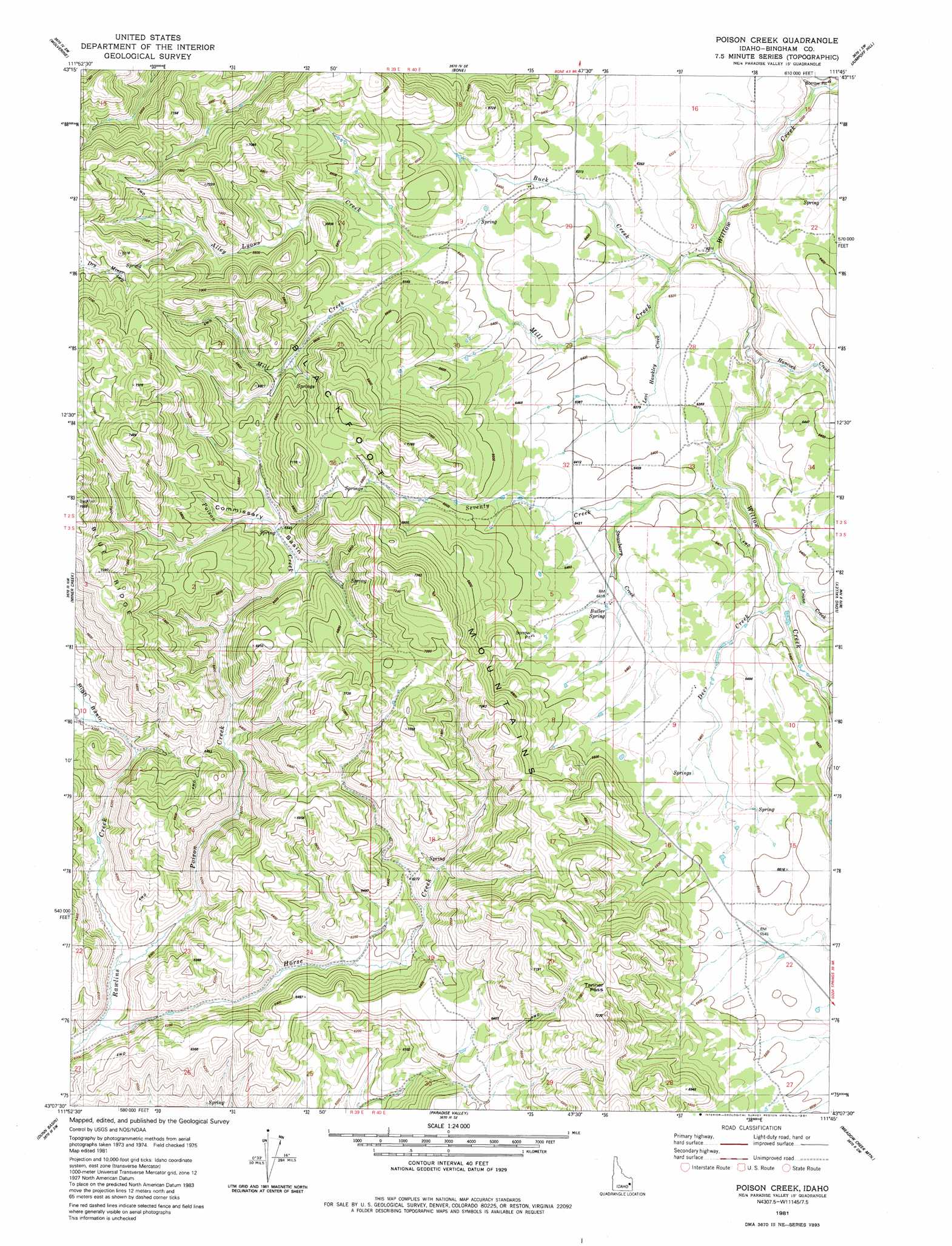
USGS Topo Quad 43111b7 - 1:24,000 scale
| Topo Map Name: | Poison Creek |
| USGS Topo Quad ID: | 43111b7 |
| Print Size: | ca. 21 1/4" wide x 27" high |
| Southeast Coordinates: | 43.125° N latitude / 111.75° W longitude |
| Map Center Coordinates: | 43.1875° N latitude / 111.8125° W longitude |
| U.S. State: | ID |
| Filename: | o43111b7.jpg |
| Download Map JPG Image: | Poison Creek topo map 1:24,000 scale |
| Map Type: | Topographic |
| Topo Series: | 7.5´ |
| Map Scale: | 1:24,000 |
| Source of Map Images: | United States Geological Survey (USGS) |
| Alternate Map Versions: |
Poison Creek ID 1981, updated 1981 Download PDF Buy paper map Poison Creek ID 2010 Download PDF Buy paper map Poison Creek ID 2013 Download PDF Buy paper map |
1:24,000 Topo Quads surrounding Poison Creek
Idaho Falls South |
Ammon |
Ozone |
Lone Pine Ridge |
Point Lookout |
Goshen |
Wolverine |
Bone |
Jumpoff Hill |
Castle Rock |
Higham Peak |
Miner Creek |
Poison Creek |
Long Valley |
Homer Valley |
Lincoln Peak |
Dunn Basin |
Paradise Valley |
Meadow Creek Mountain |
Little Valley Hills |
Jeff Cabin Creek |
Chesterfield Res |
Grizzly Creek |
Reservoir Mountain |
Henry |
> Back to 43111a1 at 1:100,000 scale
> Back to 43110a1 at 1:250,000 scale
> Back to U.S. Topo Maps home
Poison Creek topo map: Gazetteer
Poison Creek: Basins
Commissary Basin elevation 1995m 6545′Poison Creek: Gaps
Tanner Pass elevation 2137m 7011′Poison Creek: Ranges
Blackfoot Mountains elevation 2075m 6807′Poison Creek: Ridges
Blue Ridge elevation 2241m 7352′Poison Creek: Springs
Butler Spring elevation 1964m 6443′Poison Creek: Streams
Alley Lyons Creek elevation 1963m 6440′Buck Creek elevation 1898m 6227′
Crane Creek elevation 1924m 6312′
Deer Creek elevation 1925m 6315′
Hancock Creek elevation 1890m 6200′
Horse Creek elevation 1877m 6158′
Horse Creek elevation 1821m 5974′
Levi Hawkley Creek elevation 1912m 6272′
Mill Creek elevation 1892m 6207′
Poison Creek elevation 1823m 5980′
Seventy Creek elevation 1911m 6269′
Strawberry Creek elevation 1943m 6374′
Poison Creek digital topo map on disk
Buy this Poison Creek topo map showing relief, roads, GPS coordinates and other geographical features, as a high-resolution digital map file on DVD: