Ucon Topo Map Idaho
To zoom in, hover over the map of Ucon
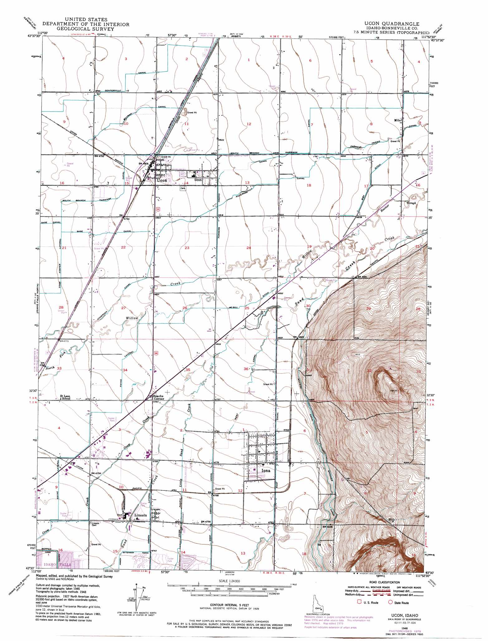
USGS Topo Quad 43111e8 - 1:24,000 scale
| Topo Map Name: | Ucon |
| USGS Topo Quad ID: | 43111e8 |
| Print Size: | ca. 21 1/4" wide x 27" high |
| Southeast Coordinates: | 43.5° N latitude / 111.875° W longitude |
| Map Center Coordinates: | 43.5625° N latitude / 111.9375° W longitude |
| U.S. State: | ID |
| Filename: | o43111e8.jpg |
| Download Map JPG Image: | Ucon topo map 1:24,000 scale |
| Map Type: | Topographic |
| Topo Series: | 7.5´ |
| Map Scale: | 1:24,000 |
| Source of Map Images: | United States Geological Survey (USGS) |
| Alternate Map Versions: |
Ucon ID 1948, updated 1973 Download PDF Buy paper map Ucon ID 1948, updated 1979 Download PDF Buy paper map Ucon ID 1948, updated 1986 Download PDF Buy paper map Ucon ID 1949 Download PDF Buy paper map Ucon ID 2011 Download PDF Buy paper map Ucon ID 2013 Download PDF Buy paper map |
1:24,000 Topo Quads surrounding Ucon
Market Lake |
Deer Parks |
Menan Buttes |
Rexburg |
Moody |
Roberts |
Lewisville |
Rigby |
Ririe |
Heise |
Shattuck Butte |
Idaho Falls North |
Ucon |
Rigby Se |
Poplar |
Woodville |
Idaho Falls South |
Ammon |
Ozone |
Lone Pine Ridge |
Firth |
Goshen |
Wolverine |
Bone |
Jumpoff Hill |
> Back to 43111e1 at 1:100,000 scale
> Back to 43110a1 at 1:250,000 scale
> Back to U.S. Topo Maps home
Ucon topo map: Gazetteer
Ucon: Canals
Ammon Extension Canal elevation 1447m 4747′Ammon Lateral elevation 1450m 4757′
Biby Ditch elevation 1482m 4862′
Billman Canal elevation 1468m 4816′
Centerville Canal elevation 1466m 4809′
East Center Canal elevation 1462m 4796′
Gardner Canal elevation 1472m 4829′
Little Sand Creek elevation 1447m 4747′
McGill Ditch elevation 1467m 4812′
Meppen Canal elevation 1443m 4734′
Norton Ditch elevation 1462m 4796′
Payne Extension elevation 1457m 4780′
Payne Lateral elevation 1455m 4773′
Ririe Outlet Canal elevation 1472m 4829′
Sand Creek elevation 1449m 4753′
South Branch Harrison Canal elevation 1476m 4842′
West Center Canal elevation 1466m 4809′
Ucon: Guts
Hodges Slough elevation 1456m 4776′Ucon: Populated Places
Beachs Corner elevation 1460m 4790′Iona elevation 1458m 4783′
Lincoln elevation 1450m 4757′
Milo elevation 1487m 4878′
Ucon elevation 1466m 4809′
Ucon: Streams
Boomer Slough elevation 1479m 4852′Willow Creek elevation 1456m 4776′
Ucon digital topo map on disk
Buy this Ucon topo map showing relief, roads, GPS coordinates and other geographical features, as a high-resolution digital map file on DVD: