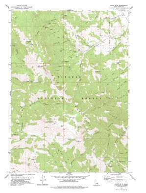
Garns Mountain Topo Map Idaho
To zoom in, hover over the map of Garns Mountain
USGS Topo Quad 43111f3 - 1:24,000 scale
| Topo Map Name: | Garns Mountain |
| USGS Topo Quad ID: | 43111f3 |
| Print Size: | ca. 21 1/4" wide x 27" high |
| Southeast Coordinates: | 43.625° N latitude / 111.25° W longitude |
| Map Center Coordinates: | 43.6875° N latitude / 111.3125° W longitude |
| U.S. State: | ID |
| Filename: | o43111f3.jpg |
| Download Map JPG Image: | Garns Mountain topo map 1:24,000 scale |
| Map Type: | Topographic |
| Topo Series: | 7.5´ |
| Map Scale: | 1:24,000 |
| Source of Map Images: | United States Geological Survey (USGS) |
| Alternate Map Versions: |
Garns Mtn. ID 1978, updated 1978 Download PDF Buy paper map Garns Mtn ID 1978, updated 1978 Download PDF Buy paper map Garns Mountain ID 2011 Download PDF Buy paper map Garns Mountain ID 2013 Download PDF Buy paper map |
| FStopo: | US Forest Service topo Garns Mountain is available: Download FStopo PDF Download FStopo TIF |
1:24,000 Topo Quads surrounding Garns Mountain
> Back to 43111e1 at 1:100,000 scale
> Back to 43110a1 at 1:250,000 scale
> Back to U.S. Topo Maps home
Garns Mountain topo map: Gazetteer
Garns Mountain: Basins
Horse Heaven elevation 2475m 8120′Packsaddle Basin elevation 2477m 8126′
Garns Mountain: Flats
Elk Flat elevation 2515m 8251′Garns Mountain: Gaps
Blacktail Pass elevation 2396m 7860′Government Trail Pass elevation 2406m 7893′
Piney Pass elevation 2401m 7877′
Garns Mountain: Lakes
Alligator Lake elevation 2097m 6879′Castle Lake elevation 2512m 8241′
Garns Mountain: Mines
Brown Bear Mine elevation 2000m 6561′Hillman Mine elevation 2159m 7083′
Idaho Mine elevation 2158m 7080′
Mikesell Mine elevation 2082m 6830′
Packsaddle Mine elevation 2221m 7286′
Pintar Mine elevation 2168m 7112′
Superior Mine elevation 2108m 6916′
Garns Mountain: Pillars
Castle Rock elevation 2463m 8080′Garns Mountain: Populated Places
Sam elevation 1979m 6492′Garns Mountain: Ranges
Big Hole Mountains elevation 2641m 8664′Garns Mountain: Ridges
Idaho Ridge elevation 2188m 7178′Long Ridge elevation 2027m 6650′
Relay Ridge elevation 2672m 8766′
Twin Creek Ridge elevation 2200m 7217′
Garns Mountain: Springs
Buck Spring elevation 2314m 7591′Packsaddle Spring elevation 2500m 8202′
Garns Mountain: Streams
Bell Creek elevation 1975m 6479′Blacktail Creek elevation 2162m 7093′
Brown Bear Creek elevation 2052m 6732′
Elk Flat Fork elevation 2069m 6788′
Hillman Creek elevation 2001m 6564′
Irene Creek elevation 2060m 6758′
North Fork Horseshoe Creek elevation 1964m 6443′
North Fork Mahogany Creek elevation 1987m 6519′
Porcupine Creek elevation 2111m 6925′
South Fork Horseshoe Creek elevation 1960m 6430′
South Fork Mahogany Creek elevation 1988m 6522′
South Fork Packsaddle Creek elevation 2162m 7093′
Superior Creek elevation 1994m 6541′
Garns Mountain: Summits
Garns Mountain elevation 2746m 9009′Henderson Peak elevation 2528m 8293′
Monument Peak elevation 2332m 7650′
Mount Manning elevation 2346m 7696′
Piney Peak elevation 2747m 9012′
Red Butte elevation 2540m 8333′
Red Mountain elevation 2651m 8697′
Ryan Peak elevation 2698m 8851′
Temple Peak elevation 2404m 7887′
Thunder Mountain elevation 2634m 8641′
Garns Mountain: Valleys
Blind Canyon elevation 2031m 6663′Buttermilk Draw elevation 1926m 6318′
Idaho Canyon elevation 1953m 6407′
Pintar Canyon elevation 2141m 7024′
Sob Canyon elevation 2059m 6755′
Woods Hollow elevation 1880m 6167′
Garns Mountain digital topo map on disk
Buy this Garns Mountain topo map showing relief, roads, GPS coordinates and other geographical features, as a high-resolution digital map file on DVD:


