Ririe Topo Map Idaho
To zoom in, hover over the map of Ririe
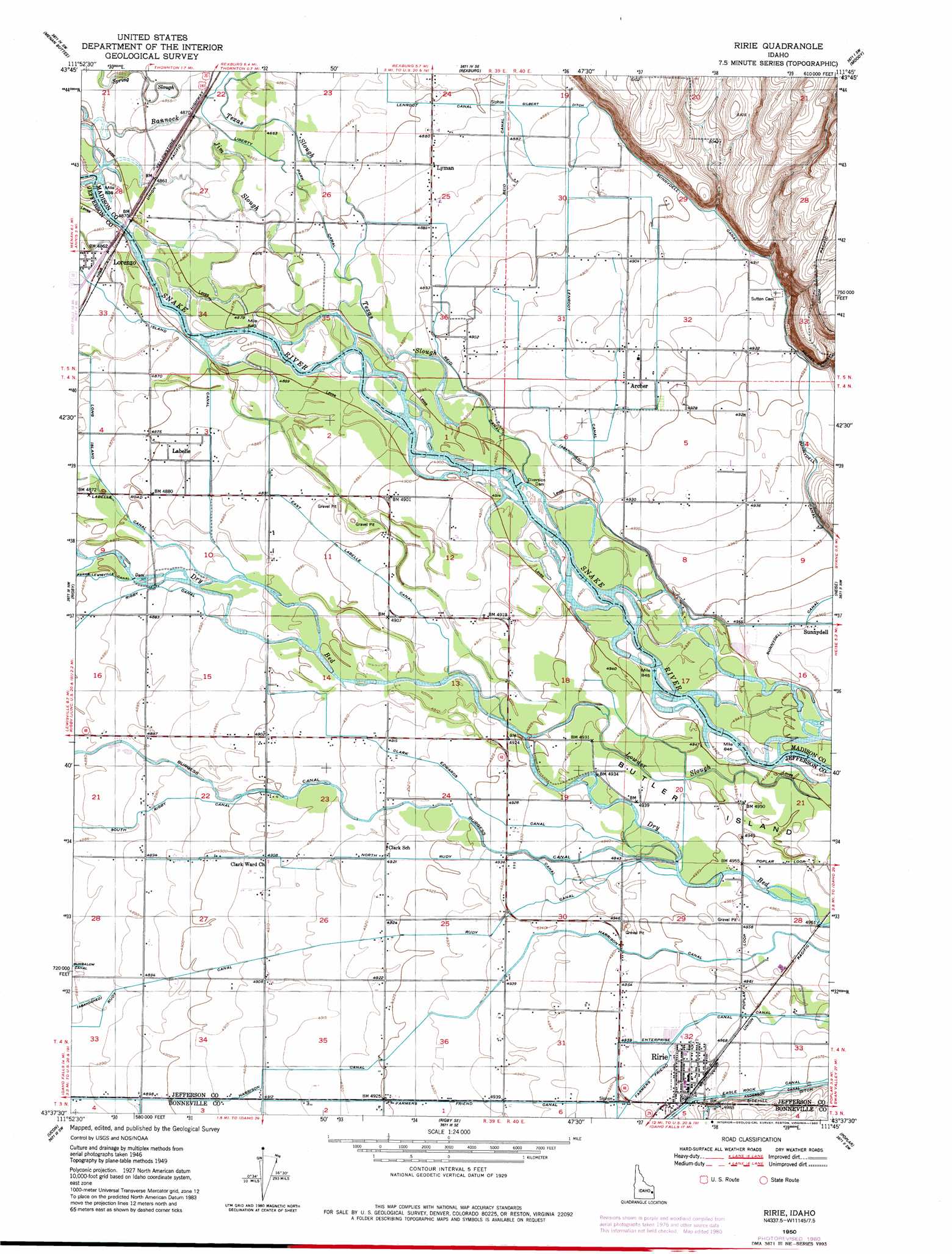
USGS Topo Quad 43111f7 - 1:24,000 scale
| Topo Map Name: | Ririe |
| USGS Topo Quad ID: | 43111f7 |
| Print Size: | ca. 21 1/4" wide x 27" high |
| Southeast Coordinates: | 43.625° N latitude / 111.75° W longitude |
| Map Center Coordinates: | 43.6875° N latitude / 111.8125° W longitude |
| U.S. State: | ID |
| Filename: | o43111f7.jpg |
| Download Map JPG Image: | Ririe topo map 1:24,000 scale |
| Map Type: | Topographic |
| Topo Series: | 7.5´ |
| Map Scale: | 1:24,000 |
| Source of Map Images: | United States Geological Survey (USGS) |
| Alternate Map Versions: |
Ririe ID 1950 Download PDF Buy paper map Ririe ID 1950, updated 1980 Download PDF Buy paper map Ririe ID 1950, updated 1980 Download PDF Buy paper map Ririe ID 2010 Download PDF Buy paper map Ririe ID 2013 Download PDF Buy paper map |
1:24,000 Topo Quads surrounding Ririe
Market Lake Ne |
Plano |
Parker |
Saint Anthony |
Newdale |
Deer Parks |
Menan Buttes |
Rexburg |
Moody |
White Owl Butte |
Lewisville |
Rigby |
Ririe |
Heise |
Hawley Gulch |
Idaho Falls North |
Ucon |
Rigby Se |
Poplar |
Heise Se |
Idaho Falls South |
Ammon |
Ozone |
Lone Pine Ridge |
Point Lookout |
> Back to 43111e1 at 1:100,000 scale
> Back to 43110a1 at 1:250,000 scale
> Back to U.S. Topo Maps home
Ririe topo map: Gazetteer
Ririe: Canals
Clark Edwards Canal elevation 1502m 4927′Eagle Rock Canal elevation 1519m 4983′
East Labelle Canal elevation 1494m 4901′
Enterprise Canal elevation 1514m 4967′
Farmers Friend Canal elevation 1500m 4921′
Gilbert Ditch elevation 1491m 4891′
Island Canal elevation 1483m 4865′
Lenroot Canal elevation 1495m 4904′
North Rudy Canal elevation 1501m 4924′
Rudy Canal elevation 1501m 4924′
Sidehill Ditch elevation 1519m 4983′
Sunnydell Canal elevation 1512m 4960′
Ririe: Populated Places
Archer elevation 1499m 4917′Labelle elevation 1488m 4881′
Lorenzo elevation 1482m 4862′
Lyman elevation 1489m 4885′
Ririe elevation 1513m 4963′
Rudy elevation 1499m 4917′
Sunnydell elevation 1513m 4963′
Ririe: Streams
Lowder Slough elevation 1501m 4924′Ririe digital topo map on disk
Buy this Ririe topo map showing relief, roads, GPS coordinates and other geographical features, as a high-resolution digital map file on DVD: