Buckskin Basin Topo Map Idaho
To zoom in, hover over the map of Buckskin Basin
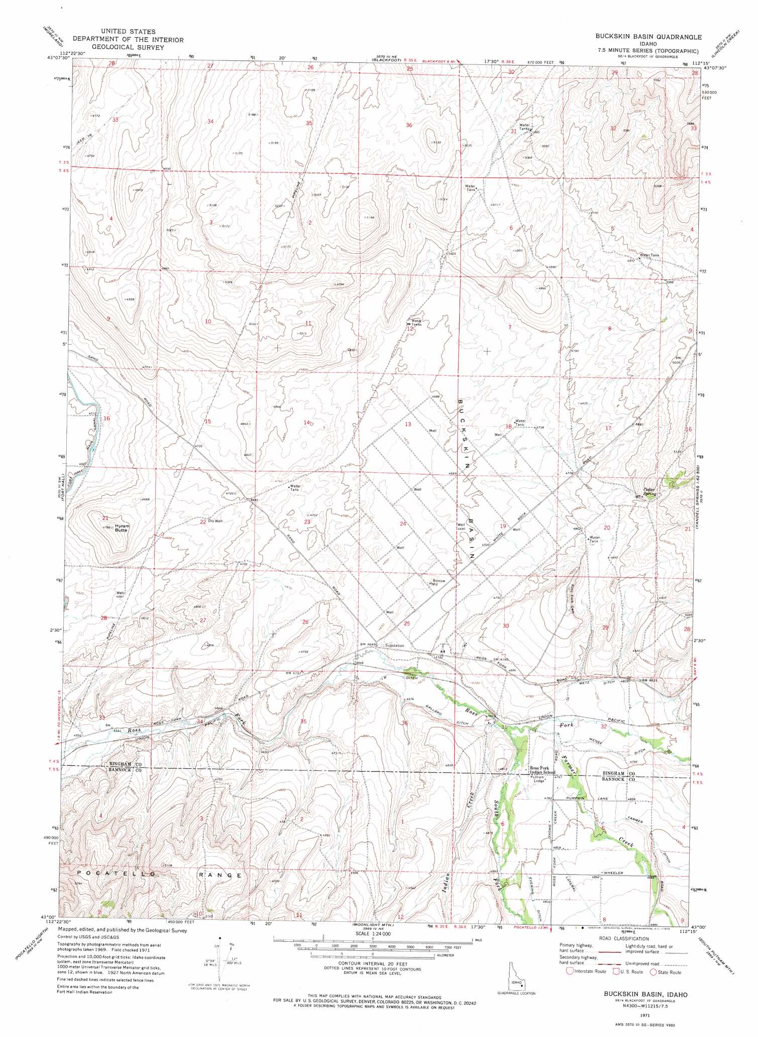
USGS Topo Quad 43112a3 - 1:24,000 scale
| Topo Map Name: | Buckskin Basin |
| USGS Topo Quad ID: | 43112a3 |
| Print Size: | ca. 21 1/4" wide x 27" high |
| Southeast Coordinates: | 43° N latitude / 112.25° W longitude |
| Map Center Coordinates: | 43.0625° N latitude / 112.3125° W longitude |
| U.S. State: | ID |
| Filename: | o43112a3.jpg |
| Download Map JPG Image: | Buckskin Basin topo map 1:24,000 scale |
| Map Type: | Topographic |
| Topo Series: | 7.5´ |
| Map Scale: | 1:24,000 |
| Source of Map Images: | United States Geological Survey (USGS) |
| Alternate Map Versions: |
Buckskin Basin ID 1971, updated 1974 Download PDF Buy paper map Buckskin Basin ID 2010 Download PDF Buy paper map Buckskin Basin ID 2013 Download PDF Buy paper map |
1:24,000 Topo Quads surrounding Buckskin Basin
Olsen |
Baldy Knoll |
Rose |
Firth |
Goshen |
Rockford |
Moreland |
Blackfoot |
Lincoln Creek |
Higham Peak |
Pingree |
Fort Hall |
Buckskin Basin |
Yandell Springs |
Lincoln Peak |
Michaud |
Pocatello North |
Moonlight Mountain |
South Putnam Mountain |
Jeff Cabin Creek |
Michaud Creek |
Pocatello South |
Inkom |
Bonneville Peak |
Bear Camp Gulch |
> Back to 43112a1 at 1:100,000 scale
> Back to 43112a1 at 1:250,000 scale
> Back to U.S. Topo Maps home
Buckskin Basin topo map: Gazetteer
Buckskin Basin: Basins
Buckskin Basin elevation 1427m 4681′Buckskin Basin: Canals
Ballard Ditch elevation 1432m 4698′Farmer Ditch elevation 1498m 4914′
IR Ditch elevation 1422m 4665′
Metz Ditch elevation 1471m 4826′
Wenee Ditch elevation 1456m 4776′
Buckskin Basin: Springs
Cedar Spring elevation 1509m 4950′Buckskin Basin: Streams
Farmer Creek elevation 1440m 4724′Indian Creek elevation 1437m 4714′
Ross Fork elevation 1482m 4862′
South Fork Ross Fork elevation 1437m 4714′
Buckskin Basin: Summits
Hyram Butte elevation 1458m 4783′Buckskin Basin: Valleys
Lone Pine Canyon elevation 1484m 4868′Buckskin Basin digital topo map on disk
Buy this Buckskin Basin topo map showing relief, roads, GPS coordinates and other geographical features, as a high-resolution digital map file on DVD: