Idaho Falls North Topo Map Idaho
To zoom in, hover over the map of Idaho Falls North
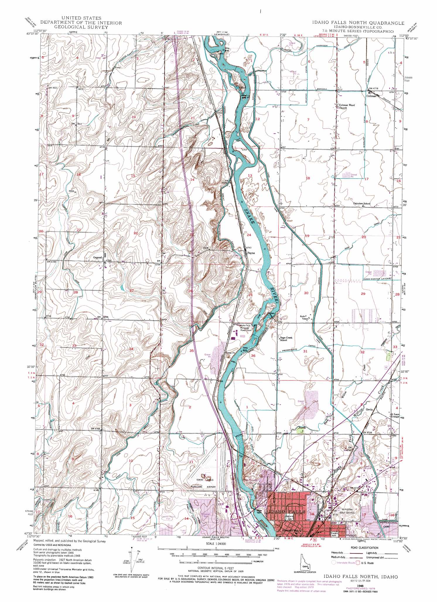
USGS Topo Quad 43112e1 - 1:24,000 scale
| Topo Map Name: | Idaho Falls North |
| USGS Topo Quad ID: | 43112e1 |
| Print Size: | ca. 21 1/4" wide x 27" high |
| Southeast Coordinates: | 43.5° N latitude / 112° W longitude |
| Map Center Coordinates: | 43.5625° N latitude / 112.0625° W longitude |
| U.S. State: | ID |
| Filename: | o43112e1.jpg |
| Download Map JPG Image: | Idaho Falls North topo map 1:24,000 scale |
| Map Type: | Topographic |
| Topo Series: | 7.5´ |
| Map Scale: | 1:24,000 |
| Source of Map Images: | United States Geological Survey (USGS) |
| Alternate Map Versions: |
Idaho Falls North ID 1948, updated 1962 Download PDF Buy paper map Idaho Falls North ID 1948, updated 1975 Download PDF Buy paper map Idaho Falls North ID 1948, updated 1980 Download PDF Buy paper map Idaho Falls North ID 1948, updated 1986 Download PDF Buy paper map Idaho Falls North ID 1949 Download PDF Buy paper map Idaho Falls North ID 2010 Download PDF Buy paper map Idaho Falls North ID 2013 Download PDF Buy paper map |
1:24,000 Topo Quads surrounding Idaho Falls North
Mud Lake Se |
Market Lake |
Deer Parks |
Menan Buttes |
Rexburg |
Kettle Butte Ne |
Roberts |
Lewisville |
Rigby |
Ririe |
Butterfly Butte |
Shattuck Butte |
Idaho Falls North |
Ucon |
Rigby Se |
Morgans Pasture Ne |
Woodville |
Idaho Falls South |
Ammon |
Ozone |
Rose |
Firth |
Goshen |
Wolverine |
Bone |
> Back to 43112e1 at 1:100,000 scale
> Back to 43112a1 at 1:250,000 scale
> Back to U.S. Topo Maps home
Idaho Falls North topo map: Gazetteer
Idaho Falls North: Airports
Fanning Field elevation 1444m 4737′Idaho Falls North: Canals
Anderson Lateral elevation 1446m 4744′Armstrong Lateral elevation 1443m 4734′
Campbell Ditch elevation 1443m 4734′
City Canal elevation 1439m 4721′
Cook-Koster Lateral elevation 1452m 4763′
Diversion Ditch elevation 1448m 4750′
East Lateral elevation 1447m 4747′
Great Western Slough elevation 1440m 4724′
Gunnerson elevation 1445m 4740′
Lateral 2 B elevation 1469m 4819′
Lateral C elevation 1470m 4822′
Lateral D elevation 1463m 4799′
Mel Fieldings Ditch elevation 1465m 4806′
Oakland Canal elevation 1446m 4744′
Osgood Canal elevation 1465m 4806′
Owners Mutual Canal elevation 1455m 4773′
Progressive Canal elevation 1448m 4750′
Sage Canal elevation 1455m 4773′
Upper Holmes Lateral elevation 1449m 4753′
Winkler Canal elevation 1456m 4776′
Idaho Falls North: Dams
Upper Idaho Falls Number One Dam elevation 1445m 4740′Upper Idaho Falls Number Two Dam elevation 1444m 4737′
Idaho Falls North: Parks
Anares Park elevation 1441m 4727′Central Park elevation 1443m 4734′
Civitan Park elevation 1439m 4721′
Esquire Acres Park elevation 1442m 4730′
Highland Park elevation 1437m 4714′
Rhinehart Park elevation 1451m 4760′
Russ Freeman Park elevation 1443m 4734′
Idaho Falls North: Populated Places
Coltman elevation 1458m 4783′Orvin elevation 1449m 4753′
Osgood elevation 1460m 4790′
Payne elevation 1447m 4747′
Idaho Falls North: Streams
North Fork Willow Creek elevation 1438m 4717′South Fork Willow Creek elevation 1430m 4691′
Idaho Falls North digital topo map on disk
Buy this Idaho Falls North topo map showing relief, roads, GPS coordinates and other geographical features, as a high-resolution digital map file on DVD: