Newman Peak Topo Map Idaho
To zoom in, hover over the map of Newman Peak
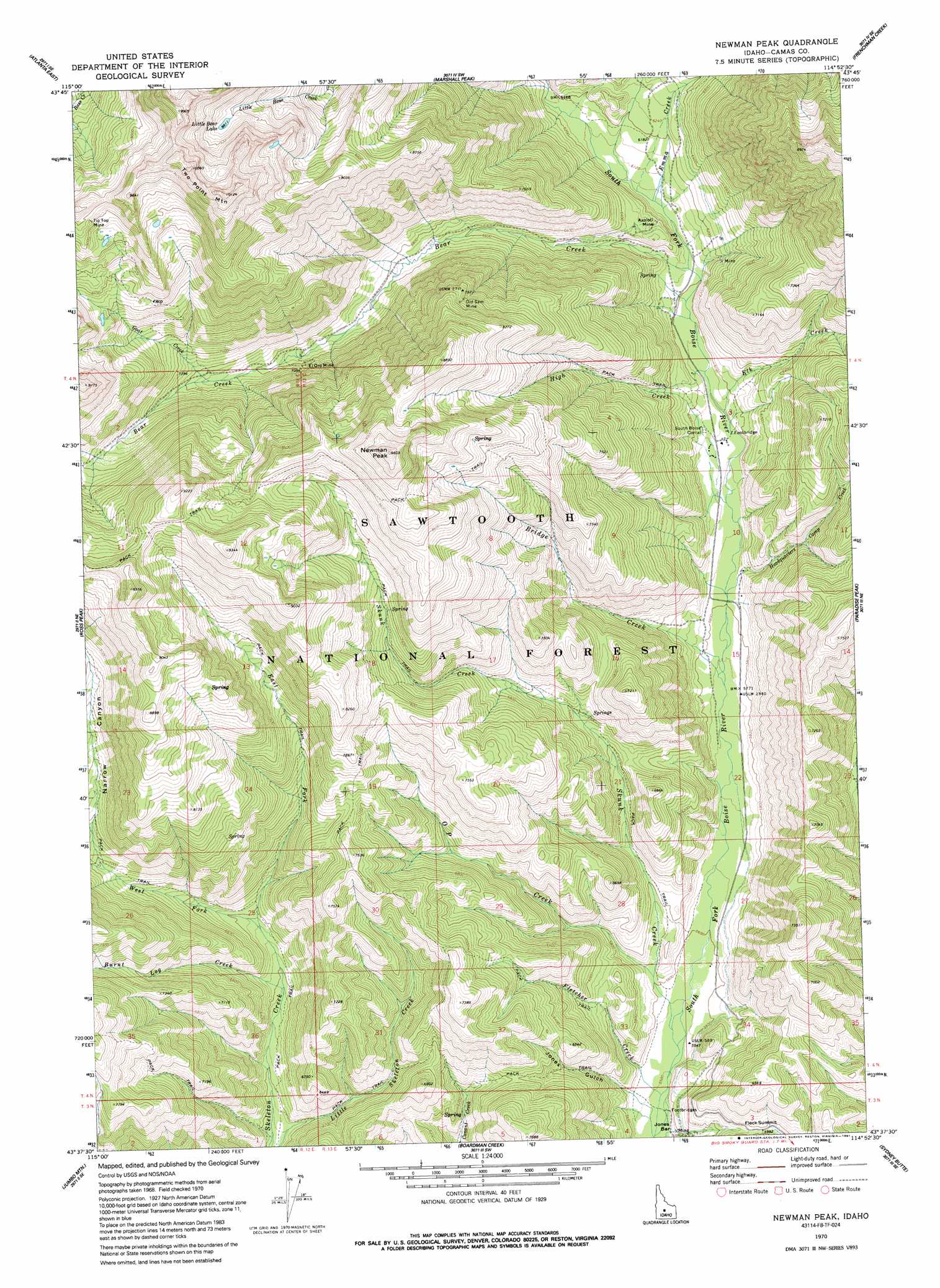
USGS Topo Quad 43114f8 - 1:24,000 scale
| Topo Map Name: | Newman Peak |
| USGS Topo Quad ID: | 43114f8 |
| Print Size: | ca. 21 1/4" wide x 27" high |
| Southeast Coordinates: | 43.625° N latitude / 114.875° W longitude |
| Map Center Coordinates: | 43.6875° N latitude / 114.9375° W longitude |
| U.S. State: | ID |
| Filename: | o43114f8.jpg |
| Download Map JPG Image: | Newman Peak topo map 1:24,000 scale |
| Map Type: | Topographic |
| Topo Series: | 7.5´ |
| Map Scale: | 1:24,000 |
| Source of Map Images: | United States Geological Survey (USGS) |
| Alternate Map Versions: |
Newman Peak ID 1970, updated 1973 Download PDF Buy paper map Newman Peak ID 1970, updated 1991 Download PDF Buy paper map Newman Peak ID 2011 Download PDF Buy paper map Newman Peak ID 2013 Download PDF Buy paper map |
| FStopo: | US Forest Service topo Newman Peak is available: Download FStopo PDF Download FStopo TIF |
1:24,000 Topo Quads surrounding Newman Peak
Nahneke Mountain |
Mount Everly |
Snowyside Peak |
Alturas Lake |
Horton Peak |
Atlanta West |
Atlanta East |
Marshall Peak |
Frenchman Creek |
Galena |
Cayuse Point |
Ross Peak |
Newman Peak |
Paradise Peak |
Baker Peak |
Grouse Butte |
Jumbo Mountain |
Boardman Creek |
Sydney Butte |
Dollarhide Mountain |
Sprout Mountain |
Deer Mountain |
Smoky Dome |
Phillips Creek |
Cannonball Mountain |
> Back to 43114e1 at 1:100,000 scale
> Back to 43114a1 at 1:250,000 scale
> Back to U.S. Topo Maps home
Newman Peak topo map: Gazetteer
Newman Peak: Lakes
Little Bear Lake elevation 2694m 8838′Newman Peak: Mines
Axolotl Mine elevation 1900m 6233′El Oro Mine elevation 2142m 7027′
Old Sam Mine elevation 2423m 7949′
Tip Top Mine elevation 2774m 9101′
Newman Peak: Streams
Bear Creek elevation 1836m 6023′Bridge Creek elevation 1754m 5754′
Burnt Log Creek elevation 1877m 6158′
East Fork Skeleton Creek elevation 1924m 6312′
Elk Creek elevation 1803m 5915′
Emma Creek elevation 1854m 6082′
Fletcher Creek elevation 1679m 5508′
Goat Creek elevation 2171m 7122′
Headquarters Camp Creek elevation 1770m 5807′
High Creek elevation 1789m 5869′
O P Creek elevation 1716m 5629′
Skunk Creek elevation 1691m 5547′
West Fork Skeleton Creek elevation 1926m 6318′
Newman Peak: Summits
Fleck Summit elevation 1831m 6007′Newman Peak elevation 2890m 9481′
Two Point Mountain elevation 3061m 10042′
Newman Peak: Valleys
Jones Gulch elevation 1699m 5574′Mill Canyon elevation 2116m 6942′
Narrow Canyon elevation 2116m 6942′
Newman Peak digital topo map on disk
Buy this Newman Peak topo map showing relief, roads, GPS coordinates and other geographical features, as a high-resolution digital map file on DVD: