Jumbo Mountain Topo Map Idaho
To zoom in, hover over the map of Jumbo Mountain
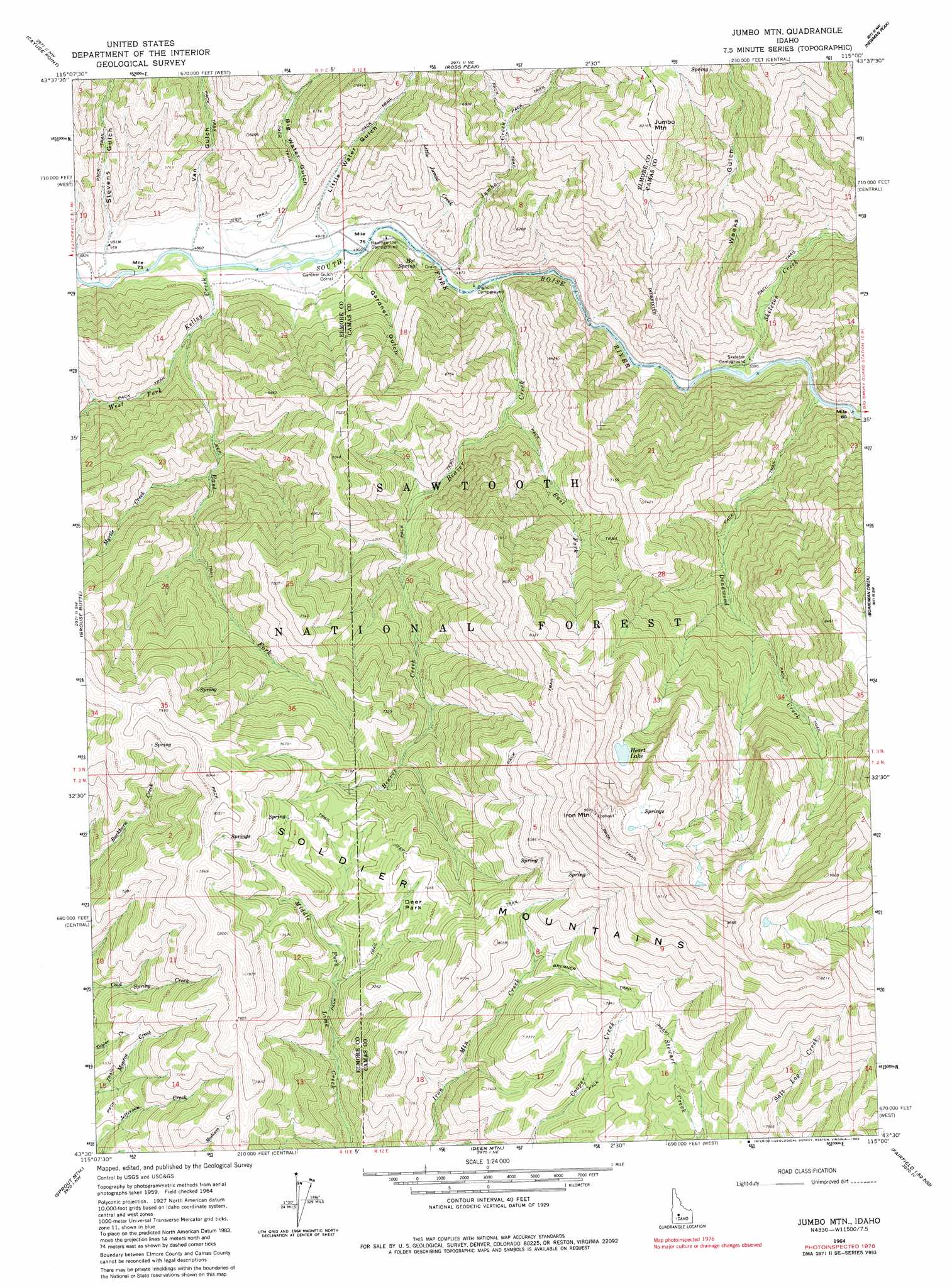
USGS Topo Quad 43115e1 - 1:24,000 scale
| Topo Map Name: | Jumbo Mountain |
| USGS Topo Quad ID: | 43115e1 |
| Print Size: | ca. 21 1/4" wide x 27" high |
| Southeast Coordinates: | 43.5° N latitude / 115° W longitude |
| Map Center Coordinates: | 43.5625° N latitude / 115.0625° W longitude |
| U.S. State: | ID |
| Filename: | o43115e1.jpg |
| Download Map JPG Image: | Jumbo Mountain topo map 1:24,000 scale |
| Map Type: | Topographic |
| Topo Series: | 7.5´ |
| Map Scale: | 1:24,000 |
| Source of Map Images: | United States Geological Survey (USGS) |
| Alternate Map Versions: |
Jumbo Mtn ID 1964, updated 1966 Download PDF Buy paper map Jumbo Mtn ID 1964, updated 1983 Download PDF Buy paper map Jumbo Mtn ID 1964, updated 1983 Download PDF Buy paper map Jumbo Mountain ID 2011 Download PDF Buy paper map Jumbo Mountain ID 2013 Download PDF Buy paper map |
| FStopo: | US Forest Service topo Jumbo Mountain is available: Download FStopo PDF Download FStopo TIF |
1:24,000 Topo Quads surrounding Jumbo Mountain
Phifer Creek |
Atlanta West |
Atlanta East |
Marshall Peak |
Frenchman Creek |
Rocky Bar |
Cayuse Point |
Ross Peak |
Newman Peak |
Paradise Peak |
Featherville |
Grouse Butte |
Jumbo Mountain |
Boardman Creek |
Sydney Butte |
Pine |
Sprout Mountain |
Deer Mountain |
Smoky Dome |
Phillips Creek |
Cat Creek Summit |
High Prairie |
Hill City |
Corral |
Fairfield |
> Back to 43115e1 at 1:100,000 scale
> Back to 43114a1 at 1:250,000 scale
> Back to U.S. Topo Maps home
Jumbo Mountain topo map: Gazetteer
Jumbo Mountain: Lakes
Heart Lake elevation 2544m 8346′Jumbo Mountain: Parks
Deer Park elevation 2204m 7230′Jumbo Mountain: Streams
Beaver Creek elevation 1512m 4960′Deadwood Creek elevation 1560m 5118′
East Fork Beaver Creek elevation 1619m 5311′
East Fork Kelley Creek elevation 1529m 5016′
Jumbo Creek elevation 1500m 4921′
Kelley Creek elevation 1476m 4842′
Little Jumbo Creek elevation 1504m 4934′
Myrtle Creek elevation 1669m 5475′
Skeleton Creek elevation 1546m 5072′
West Fork Kelley Creek elevation 1529m 5016′
Jumbo Mountain: Summits
Iron Mountain elevation 2942m 9652′Jumbo Mountain elevation 2493m 8179′
Jumbo Mountain: Valleys
Big Water Gulch elevation 1509m 4950′Gardner Gulch elevation 1524m 5000′
Little Water Gulch elevation 1510m 4954′
Stevens Gulch elevation 1477m 4845′
Van Gulch elevation 1490m 4888′
Weeks Gulch elevation 1578m 5177′
Jumbo Mountain digital topo map on disk
Buy this Jumbo Mountain topo map showing relief, roads, GPS coordinates and other geographical features, as a high-resolution digital map file on DVD: