Trinity Mountain Topo Map Idaho
To zoom in, hover over the map of Trinity Mountain
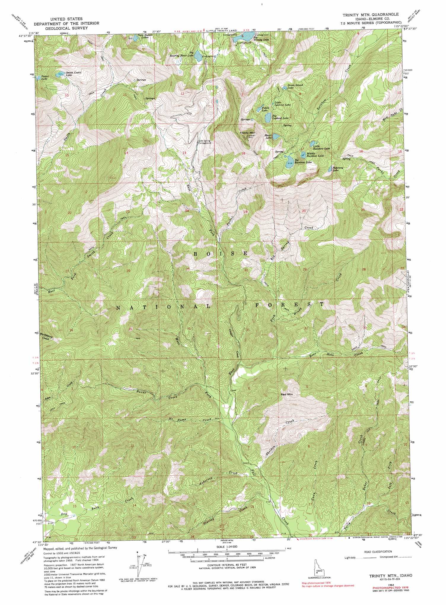
USGS Topo Quad 43115e4 - 1:24,000 scale
| Topo Map Name: | Trinity Mountain |
| USGS Topo Quad ID: | 43115e4 |
| Print Size: | ca. 21 1/4" wide x 27" high |
| Southeast Coordinates: | 43.5° N latitude / 115.375° W longitude |
| Map Center Coordinates: | 43.5625° N latitude / 115.4375° W longitude |
| U.S. State: | ID |
| Filename: | o43115e4.jpg |
| Download Map JPG Image: | Trinity Mountain topo map 1:24,000 scale |
| Map Type: | Topographic |
| Topo Series: | 7.5´ |
| Map Scale: | 1:24,000 |
| Source of Map Images: | United States Geological Survey (USGS) |
| Alternate Map Versions: |
Trinity Mtn ID 1964, updated 1966 Download PDF Buy paper map Trinity Mtn ID 1964, updated 1986 Download PDF Buy paper map Trinity Mtn ID 1964, updated 1986 Download PDF Buy paper map Trinity Mountain ID 2011 Download PDF Buy paper map Trinity Mountain ID 2013 Download PDF Buy paper map |
| FStopo: | US Forest Service topo Trinity Mountain is available: Download FStopo PDF Download FStopo TIF |
1:24,000 Topo Quads surrounding Trinity Mountain
Rabbit Creek Summit |
Barber Flat |
Grand Mountain |
Phifer Creek |
Atlanta West |
Twin Springs |
Sheep Creek |
Little Trinity Lake |
Rocky Bar |
Cayuse Point |
Long Gulch |
Prairie |
Trinity Mountain |
Featherville |
Grouse Butte |
Danskin Peak |
Cathedral Rocks |
House Mountain |
Pine |
Sprout Mountain |
Syrup Creek |
Long Tom Reservoir |
Anderson Ranch Dam |
Cat Creek Summit |
High Prairie |
> Back to 43115e1 at 1:100,000 scale
> Back to 43114a1 at 1:250,000 scale
> Back to U.S. Topo Maps home
Trinity Mountain topo map: Gazetteer
Trinity Mountain: Lakes
Big Lookout Lake elevation 2505m 8218′Big Rainbow Lake elevation 2484m 8149′
Big Roaring River Lake elevation 2457m 8061′
Big Trinity Lake elevation 2365m 7759′
Fiddle Lake elevation 2517m 8257′
Green Island Lake elevation 2437m 7995′
Heart Lake elevation 2481m 8139′
Hideway Lake elevation 2570m 8431′
Little Lookout Lake elevation 2497m 8192′
Little Rainbow Lake elevation 2376m 7795′
Middle Rainbow Lake elevation 2424m 7952′
Potter Lake elevation 2508m 8228′
Smith Creek Lake elevation 2399m 7870′
Trinity Mountain: Streams
Anderson Creek elevation 1591m 5219′Baker Creek elevation 1595m 5232′
Bear Hole Creek elevation 1735m 5692′
Big Spring Creek elevation 1852m 6076′
Burnt Creek elevation 1658m 5439′
Cougar Creek elevation 1684m 5524′
East Fork Fall Creek elevation 1625m 5331′
Left Fork Tally Creek elevation 1607m 5272′
No Name Creek elevation 1630m 5347′
Packer Creek elevation 1961m 6433′
Sheldon Creek elevation 1571m 5154′
Stavley Creek elevation 1562m 5124′
West Fork Fall Creek elevation 1625m 5331′
Windy Creek elevation 1783m 5849′
Trinity Mountain: Summits
Red Mountain elevation 2125m 6971′Trinity Mountain elevation 2880m 9448′
Trinity Mountain digital topo map on disk
Buy this Trinity Mountain topo map showing relief, roads, GPS coordinates and other geographical features, as a high-resolution digital map file on DVD: