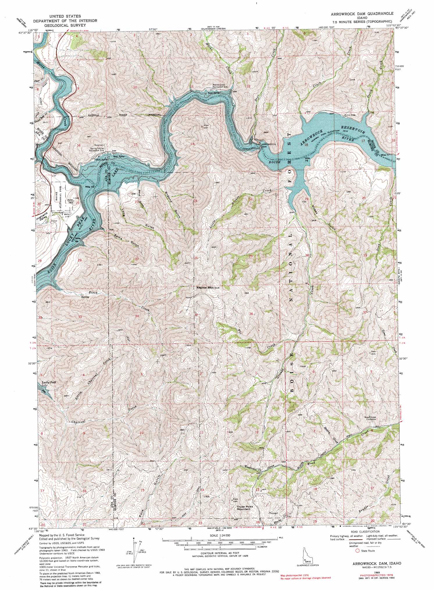
Arrowrock Dam Topo Map Idaho
To zoom in, hover over the map of Arrowrock Dam
USGS Topo Quad 43115e8 - 1:24,000 scale
| Topo Map Name: | Arrowrock Dam |
| USGS Topo Quad ID: | 43115e8 |
| Print Size: | ca. 21 1/4" wide x 27" high |
| Southeast Coordinates: | 43.5° N latitude / 115.875° W longitude |
| Map Center Coordinates: | 43.5625° N latitude / 115.9375° W longitude |
| U.S. State: | ID |
| Filename: | o43115e8.jpg |
| Download Map JPG Image: | Arrowrock Dam topo map 1:24,000 scale |
| Map Type: | Topographic |
| Topo Series: | 7.5´ |
| Map Scale: | 1:24,000 |
| Source of Map Images: | United States Geological Survey (USGS) |
| Alternate Map Versions: |
Arrowrock Dam ID 1969, updated 1972 Download PDF Buy paper map Arrowrock Dam ID 1969, updated 1982 Download PDF Buy paper map Arrowrock Dam ID 2011 Download PDF Buy paper map Arrowrock Dam ID 2013 Download PDF Buy paper map |
| FStopo: | US Forest Service topo Arrowrock Dam is available: Download FStopo PDF Download FStopo TIF |
1:24,000 Topo Quads surrounding Arrowrock Dam
Cartwright Canyon |
Shafer Butte |
Warm Springs Point |
Idaho City |
Rabbit Creek Summit |
Boise North |
Robie Creek |
Dunnigan Creek |
Arrowrock Reservoir Ne |
Twin Springs |
Boise South |
Lucky Peak |
Arrowrock Dam |
Grape Mountain |
Long Gulch |
Owyhee |
Indian Creek Reservoir |
Mayfield |
Braves Creek |
Danskin Peak |
Christmas Mountain |
Orchard |
Mayfield Sw |
Mayfield Se |
Syrup Creek |
> Back to 43115e1 at 1:100,000 scale
> Back to 43114a1 at 1:250,000 scale
> Back to U.S. Topo Maps home
Arrowrock Dam topo map: Gazetteer
Arrowrock Dam: Dams
Arrowrock Dam elevation 975m 3198′Arrowrock Dam: Reservoirs
Arrowrock Reservoir elevation 975m 3198′Arrowrock Dam: Streams
Birch Creek elevation 938m 3077′Cinch Creek elevation 981m 3218′
Dead Dog Creek elevation 936m 3070′
Deep Creek elevation 990m 3248′
Deer Creek elevation 940m 3083′
Deer Creek elevation 934m 3064′
Dutch Creek elevation 985m 3231′
Fir Creek elevation 1155m 3789′
Grouse Creek elevation 986m 3234′
Little Charcoal Creek elevation 961m 3152′
Little Grouse Creek elevation 983m 3225′
Macks Creek elevation 943m 3093′
Mores Creek elevation 934m 3064′
Station Creek elevation 1236m 4055′
Woodtick Creek elevation 1387m 4550′
Arrowrock Dam: Summits
Kepros Mountain elevation 1649m 5410′Three Point Mountain elevation 1618m 5308′
Arrowrock Dam: Valleys
Bend Gulch elevation 940m 3083′Browns Gulch elevation 936m 3070′
Guess Gulch elevation 989m 3244′
Highland Valley elevation 982m 3221′
Long Gulch elevation 939m 3080′
Sams Gulch elevation 951m 3120′
Arrowrock Dam digital topo map on disk
Buy this Arrowrock Dam topo map showing relief, roads, GPS coordinates and other geographical features, as a high-resolution digital map file on DVD: