Little Trinity Lake Topo Map Idaho
To zoom in, hover over the map of Little Trinity Lake
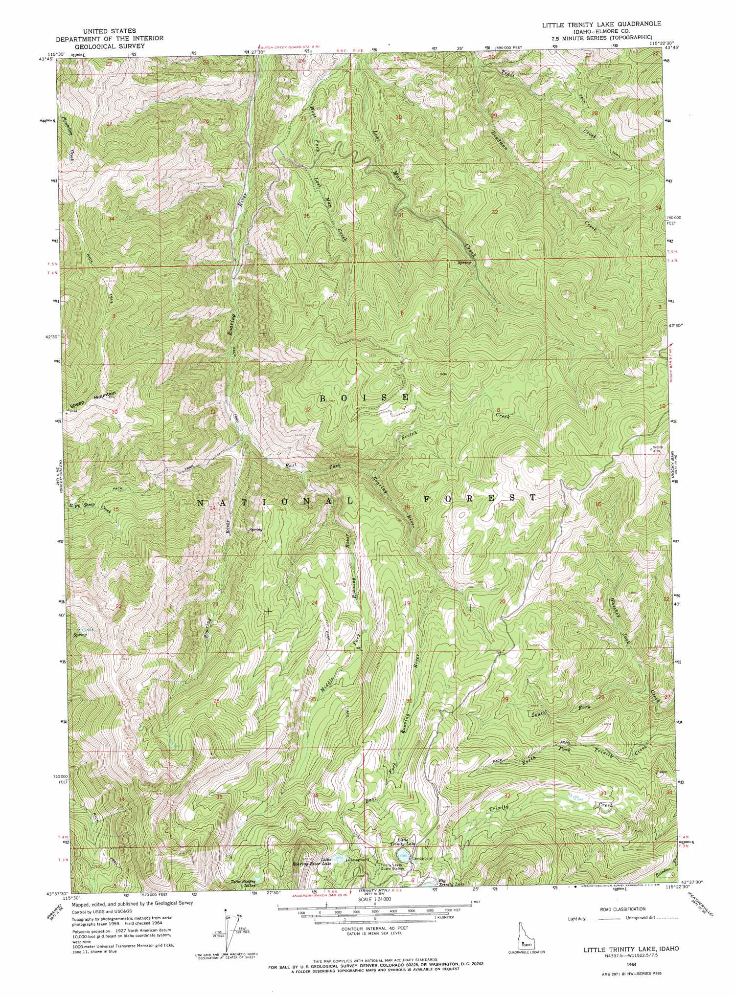
USGS Topo Quad 43115f4 - 1:24,000 scale
| Topo Map Name: | Little Trinity Lake |
| USGS Topo Quad ID: | 43115f4 |
| Print Size: | ca. 21 1/4" wide x 27" high |
| Southeast Coordinates: | 43.625° N latitude / 115.375° W longitude |
| Map Center Coordinates: | 43.6875° N latitude / 115.4375° W longitude |
| U.S. State: | ID |
| Filename: | o43115f4.jpg |
| Download Map JPG Image: | Little Trinity Lake topo map 1:24,000 scale |
| Map Type: | Topographic |
| Topo Series: | 7.5´ |
| Map Scale: | 1:24,000 |
| Source of Map Images: | United States Geological Survey (USGS) |
| Alternate Map Versions: |
Little Trinity Lake ID 1964, updated 1966 Download PDF Buy paper map Little Trinity Lake ID 1964, updated 1966 Download PDF Buy paper map Little Trinity Lake ID 2011 Download PDF Buy paper map Little Trinity Lake ID 2013 Download PDF Buy paper map |
| FStopo: | US Forest Service topo Little Trinity Lake is available: Download FStopo PDF Download FStopo TIF |
1:24,000 Topo Quads surrounding Little Trinity Lake
Sunset Mountain |
Big Owl Creek |
Bear River |
Swanholm Peak |
Nahneke Mountain |
Rabbit Creek Summit |
Barber Flat |
Grand Mountain |
Phifer Creek |
Atlanta West |
Twin Springs |
Sheep Creek |
Little Trinity Lake |
Rocky Bar |
Cayuse Point |
Long Gulch |
Prairie |
Trinity Mountain |
Featherville |
Grouse Butte |
Danskin Peak |
Cathedral Rocks |
House Mountain |
Pine |
Sprout Mountain |
> Back to 43115e1 at 1:100,000 scale
> Back to 43114a1 at 1:250,000 scale
> Back to U.S. Topo Maps home
Little Trinity Lake topo map: Gazetteer
Little Trinity Lake: Lakes
Little Roaring River Lake elevation 2387m 7831′Little Trinity Lake elevation 2376m 7795′
Twin Sisters Lakes elevation 2444m 8018′
Little Trinity Lake: Ranges
Trinity Mountains elevation 2058m 6751′Little Trinity Lake: Streams
Deadman Creek elevation 1620m 5314′East Fork Roaring River elevation 1658m 5439′
Middle Fork Roaring River elevation 1763m 5784′
Scotch Creek elevation 1881m 6171′
South Fork Whiskey Jack Creek elevation 1826m 5990′
Little Trinity Lake: Summits
Sheep Mountain elevation 2472m 8110′Little Trinity Lake: Trails
Roaring River Trail elevation 2127m 6978′Little Trinity Lake digital topo map on disk
Buy this Little Trinity Lake topo map showing relief, roads, GPS coordinates and other geographical features, as a high-resolution digital map file on DVD: