Atlanta West Topo Map Idaho
To zoom in, hover over the map of Atlanta West
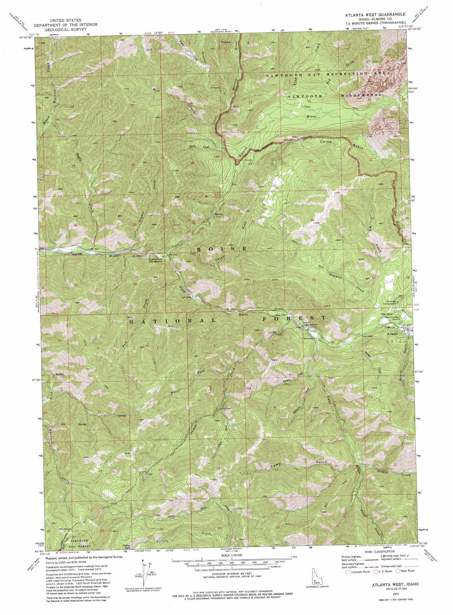
USGS Topo Quad 43115g2 - 1:24,000 scale
| Topo Map Name: | Atlanta West |
| USGS Topo Quad ID: | 43115g2 |
| Print Size: | ca. 21 1/4" wide x 27" high |
| Southeast Coordinates: | 43.75° N latitude / 115.125° W longitude |
| Map Center Coordinates: | 43.8125° N latitude / 115.1875° W longitude |
| U.S. State: | ID |
| Filename: | o43115g2.jpg |
| Download Map JPG Image: | Atlanta West topo map 1:24,000 scale |
| Map Type: | Topographic |
| Topo Series: | 7.5´ |
| Map Scale: | 1:24,000 |
| Source of Map Images: | United States Geological Survey (USGS) |
| Alternate Map Versions: |
Atlanta West ID 1972, updated 1977 Download PDF Buy paper map Atlanta West ID 1972, updated 1985 Download PDF Buy paper map Atlanta West ID 1972, updated 1985 Download PDF Buy paper map Atlanta West ID 2011 Download PDF Buy paper map Atlanta West ID 2013 Download PDF Buy paper map |
| FStopo: | US Forest Service topo Atlanta West is available: Download FStopo PDF Download FStopo TIF |
1:24,000 Topo Quads surrounding Atlanta West
Jackson Peak |
Tyee Mountain |
Edaho Mountain |
Warbonnet Peak |
Mount Cramer |
Bear River |
Swanholm Peak |
Nahneke Mountain |
Mount Everly |
Snowyside Peak |
Grand Mountain |
Phifer Creek |
Atlanta West |
Atlanta East |
Marshall Peak |
Little Trinity Lake |
Rocky Bar |
Cayuse Point |
Ross Peak |
Newman Peak |
Trinity Mountain |
Featherville |
Grouse Butte |
Jumbo Mountain |
Boardman Creek |
> Back to 43115e1 at 1:100,000 scale
> Back to 43114a1 at 1:250,000 scale
> Back to U.S. Topo Maps home
Atlanta West topo map: Gazetteer
Atlanta West: Airports
Atlanta Airport elevation 1650m 5413′Atlanta West: Basins
China Basin elevation 1862m 6108′Atlanta West: Populated Places
Alturas City (historical) elevation 1600m 5249′Atlanta elevation 1656m 5433′
Atlanta West: Streams
Basque Creek elevation 1600m 5249′Browns Creek elevation 1658m 5439′
China Fork elevation 1535m 5036′
Decker Creek elevation 1666m 5465′
Eagle Creek elevation 1479m 4852′
East Fork James Creek elevation 1950m 6397′
Fall Creek elevation 1531m 5022′
James Creek elevation 1570m 5150′
Kid Creek elevation 1682m 5518′
King Creek elevation 1672m 5485′
Little Queens River elevation 1602m 5255′
McGuire Creek elevation 1604m 5262′
Mill Creek elevation 1669m 5475′
Montezuma Creek elevation 1604m 5262′
Queens River elevation 1500m 4921′
Rabbit Creek elevation 1583m 5193′
Right Creek elevation 1831m 6007′
Sawmill Creek elevation 1599m 5246′
Snyder Creek elevation 1490m 4888′
Steep Creek elevation 1621m 5318′
Trail Creek elevation 1699m 5574′
West Fork James Creek elevation 1824m 5984′
Yuba River elevation 1572m 5157′
Atlanta West: Summits
James Creek Summit elevation 2380m 7808′Atlanta West: Trails
Black Warrior Creek Trail elevation 1746m 5728′Atlanta West: Valleys
Big Gulch elevation 1691m 5547′Camp Gulch elevation 1673m 5488′
Quartz Gulch elevation 1647m 5403′
Atlanta West digital topo map on disk
Buy this Atlanta West topo map showing relief, roads, GPS coordinates and other geographical features, as a high-resolution digital map file on DVD: