Phifer Creek Topo Map Idaho
To zoom in, hover over the map of Phifer Creek
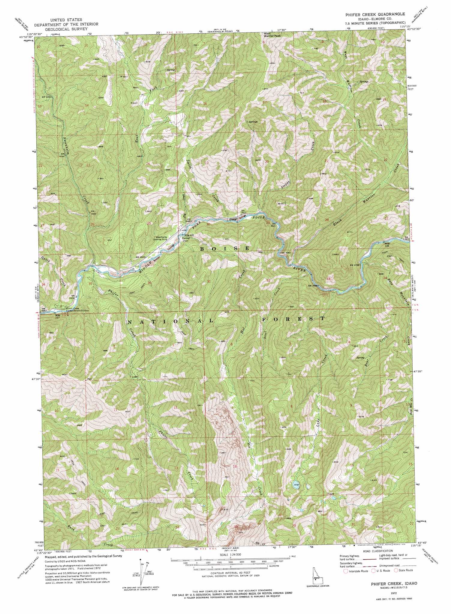
USGS Topo Quad 43115g3 - 1:24,000 scale
| Topo Map Name: | Phifer Creek |
| USGS Topo Quad ID: | 43115g3 |
| Print Size: | ca. 21 1/4" wide x 27" high |
| Southeast Coordinates: | 43.75° N latitude / 115.25° W longitude |
| Map Center Coordinates: | 43.8125° N latitude / 115.3125° W longitude |
| U.S. State: | ID |
| Filename: | o43115g3.jpg |
| Download Map JPG Image: | Phifer Creek topo map 1:24,000 scale |
| Map Type: | Topographic |
| Topo Series: | 7.5´ |
| Map Scale: | 1:24,000 |
| Source of Map Images: | United States Geological Survey (USGS) |
| Alternate Map Versions: |
Phifer Creek ID 1972, updated 1976 Download PDF Buy paper map Phifer Creek ID 2011 Download PDF Buy paper map Phifer Creek ID 2013 Download PDF Buy paper map |
| FStopo: | US Forest Service topo Phifer Creek is available: Download FStopo PDF Download FStopo TIF |
1:24,000 Topo Quads surrounding Phifer Creek
Lowman |
Jackson Peak |
Tyee Mountain |
Edaho Mountain |
Warbonnet Peak |
Big Owl Creek |
Bear River |
Swanholm Peak |
Nahneke Mountain |
Mount Everly |
Barber Flat |
Grand Mountain |
Phifer Creek |
Atlanta West |
Atlanta East |
Sheep Creek |
Little Trinity Lake |
Rocky Bar |
Cayuse Point |
Ross Peak |
Prairie |
Trinity Mountain |
Featherville |
Grouse Butte |
Jumbo Mountain |
> Back to 43115e1 at 1:100,000 scale
> Back to 43114a1 at 1:250,000 scale
> Back to U.S. Topo Maps home
Phifer Creek topo map: Gazetteer
Phifer Creek: Airports
Weatherby-US Forest Service Airport elevation 1369m 4491′Phifer Creek: Streams
Bald Mountain Creek elevation 1450m 4757′Bear Creek elevation 1439m 4721′
Black Warrior Creek elevation 1406m 4612′
Dutch Creek elevation 1311m 4301′
East Fork Swanholm Creek elevation 1373m 4504′
Fly Creek elevation 1355m 4445′
Hot Creek elevation 1352m 4435′
Lake Creek elevation 1430m 4691′
Phifer Creek elevation 1331m 4366′
Smith Creek elevation 1368m 4488′
Steel Creek elevation 1422m 4665′
Steppe Creek elevation 1377m 4517′
Swanholm Creek elevation 1332m 4370′
West Warrior Creek elevation 1544m 5065′
Phifer Creek: Trails
Hot Springs Creek Trail elevation 1829m 6000′Phifer Creek digital topo map on disk
Buy this Phifer Creek topo map showing relief, roads, GPS coordinates and other geographical features, as a high-resolution digital map file on DVD: