Mount Everly Topo Map Idaho
To zoom in, hover over the map of Mount Everly
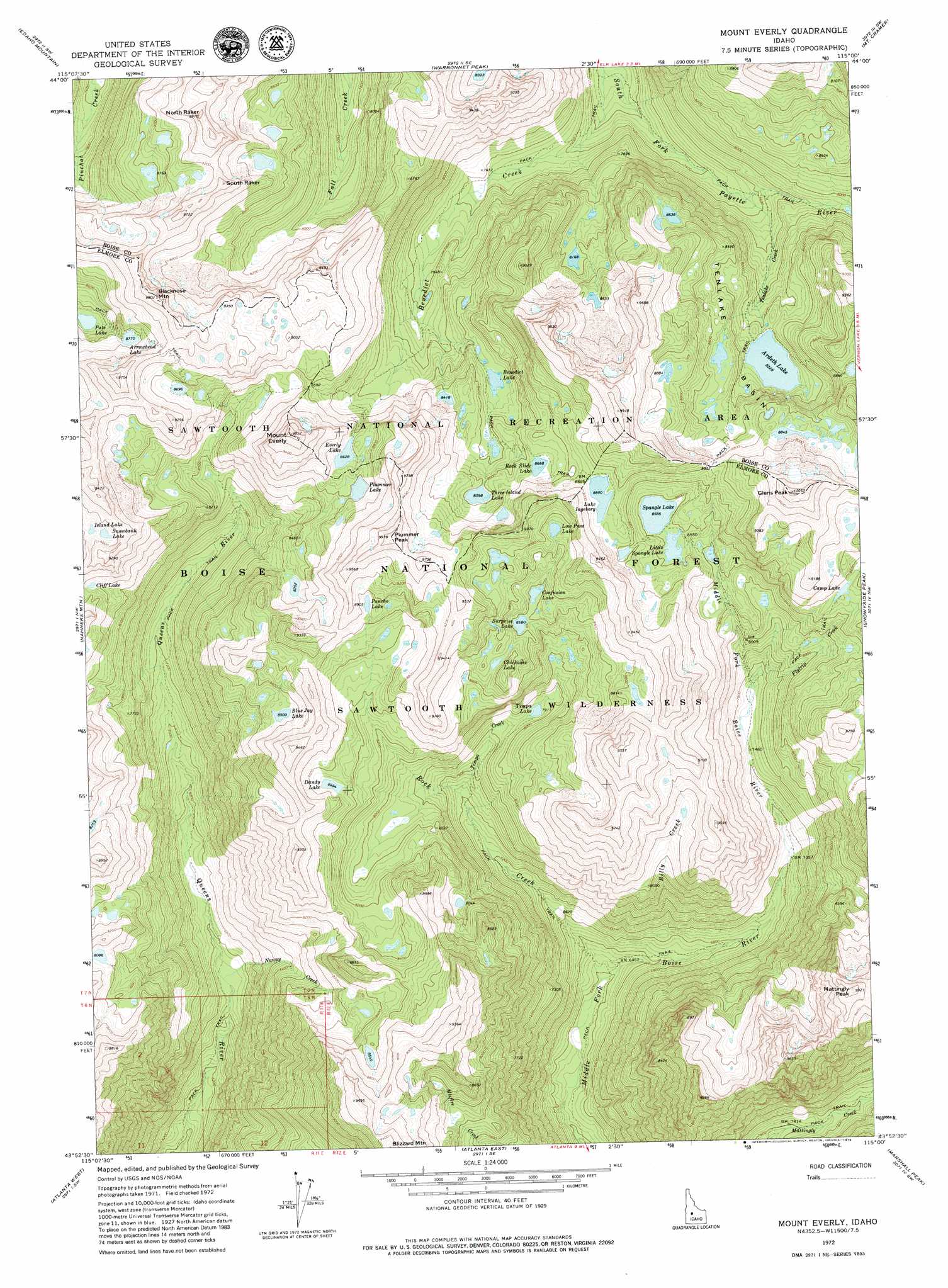
USGS Topo Quad 43115h1 - 1:24,000 scale
| Topo Map Name: | Mount Everly |
| USGS Topo Quad ID: | 43115h1 |
| Print Size: | ca. 21 1/4" wide x 27" high |
| Southeast Coordinates: | 43.875° N latitude / 115° W longitude |
| Map Center Coordinates: | 43.9375° N latitude / 115.0625° W longitude |
| U.S. State: | ID |
| Filename: | o43115h1.jpg |
| Download Map JPG Image: | Mount Everly topo map 1:24,000 scale |
| Map Type: | Topographic |
| Topo Series: | 7.5´ |
| Map Scale: | 1:24,000 |
| Source of Map Images: | United States Geological Survey (USGS) |
| Alternate Map Versions: |
Mount Everly ID 1972, updated 1976 Download PDF Buy paper map Mount Everly ID 2011 Download PDF Buy paper map Mount Everly ID 2013 Download PDF Buy paper map |
| FStopo: | US Forest Service topo Mount Everly is available: Download FStopo PDF Download FStopo TIF |
1:24,000 Topo Quads surrounding Mount Everly
Eightmile Mountain |
Grandjean |
Stanley Lake |
Stanley |
Casino Lakes |
Tyee Mountain |
Edaho Mountain |
Warbonnet Peak |
Mount Cramer |
Obsidian |
Swanholm Peak |
Nahneke Mountain |
Mount Everly |
Snowyside Peak |
Alturas Lake |
Phifer Creek |
Atlanta West |
Atlanta East |
Marshall Peak |
Frenchman Creek |
Rocky Bar |
Cayuse Point |
Ross Peak |
Newman Peak |
Paradise Peak |
> Back to 43115e1 at 1:100,000 scale
> Back to 43114a1 at 1:250,000 scale
> Back to U.S. Topo Maps home
Mount Everly topo map: Gazetteer
Mount Everly: Basins
Tenlake Basin elevation 2594m 8510′Mount Everly: Lakes
Ardeth Lake elevation 2509m 8231′Arrowhead Lake elevation 2677m 8782′
Benedict Lake elevation 2518m 8261′
Blue Jay Lake elevation 2593m 8507′
Camp Lake elevation 2596m 8517′
Chickadee Lake elevation 2655m 8710′
Cliff Lake elevation 2595m 8513′
Confusion Lake elevation 2622m 8602′
Dandy Lake elevation 2592m 8503′
Everly Lake elevation 2631m 8631′
Island Lake elevation 2691m 8828′
Lake Ingeborg elevation 2711m 8894′
Little Spangle Lake elevation 2614m 8576′
Low Pass Lake elevation 2714m 8904′
Pancho Lake elevation 2715m 8907′
Pats Lake elevation 2542m 8339′
Plummer Lake elevation 2622m 8602′
Rock Slide Lake elevation 2641m 8664′
Snowbank Lake elevation 2702m 8864′
Spangle Lake elevation 2618m 8589′
Spangle Lakes elevation 2635m 8645′
Surprise Lake elevation 2617m 8585′
Tenlake Basin elevation 2595m 8513′
Three Island Lake elevation 2622m 8602′
Timpa Lake elevation 2414m 7919′
Mount Everly: Streams
Benedict Creek elevation 2153m 7063′Billy Creek elevation 1988m 6522′
Flytrip Creek elevation 2287m 7503′
Nanny Creek elevation 1981m 6499′
Rock Creek elevation 1946m 6384′
Tenlake Creek elevation 2294m 7526′
Timpa Creek elevation 2264m 7427′
Mount Everly: Summits
Blacknose Mountain elevation 2981m 9780′Glens Peak elevation 3065m 10055′
Mattingly Peak elevation 3022m 9914′
Mount Everly elevation 2999m 9839′
North Raker elevation 3026m 9927′
Plummer Peak elevation 3039m 9970′
South Raker elevation 2903m 9524′
The Rakers elevation 2949m 9675′
Mount Everly digital topo map on disk
Buy this Mount Everly topo map showing relief, roads, GPS coordinates and other geographical features, as a high-resolution digital map file on DVD: